

Aerial Archaeology in Ireland - The Heritage Council
Aerial Archaeology in Ireland - The Heritage Council
Aerial Archaeology in Ireland - The Heritage Council

You also want an ePaper? Increase the reach of your titles
YUMPU automatically turns print PDFs into web optimized ePapers that Google loves.
86<br />
Roads<br />
<strong>The</strong> National Roads Authority’s archaeological code of practice was drawn up <strong>in</strong> recognition of the major road construction<br />
programme outl<strong>in</strong>ed <strong>in</strong> the National Development Plan for 2001-2006. It outl<strong>in</strong>es a basic framework of <strong>in</strong>tegrat<strong>in</strong>g archaeological<br />
assessment and mitigation of construction impacts for all stages of road development projects, from route selection to on-site<br />
construction. This <strong>in</strong>cludes the NRA’s commitment to ensure that a project archaeologist is appo<strong>in</strong>ted by the local authority to<br />
oversee the archaeological process. One of the stages of work with<strong>in</strong> this role is a requirement<br />
‘…to prepare the specification for the consultant archaeologist at EIA stage and ensure that all preparatory<br />
archaeological work (desk study/field walk<strong>in</strong>g, aerial photography and if necessary geophysical surveys<br />
etc.) for the EIA is of the highest standard…’<br />
While this allows for some flexibility of application, the NRA archaeologist reports that<br />
NRA undated, Appendix 1<br />
‘Currently we are request<strong>in</strong>g all potential new routes to be flown and photographed from an archaeological<br />
perspective. <strong>The</strong> time of the year that the aerial photography is carried out is crucial.’<br />
Daire O’Rourke pers. comm.<br />
<strong>The</strong> NRA itself, along with archaeological consultants and contractors, report a considerable <strong>in</strong>crease <strong>in</strong> the use of aerial<br />
archaeology <strong>in</strong> the context of road schemes, hav<strong>in</strong>g a role at several different stages from Environmental Impact Assessment to<br />
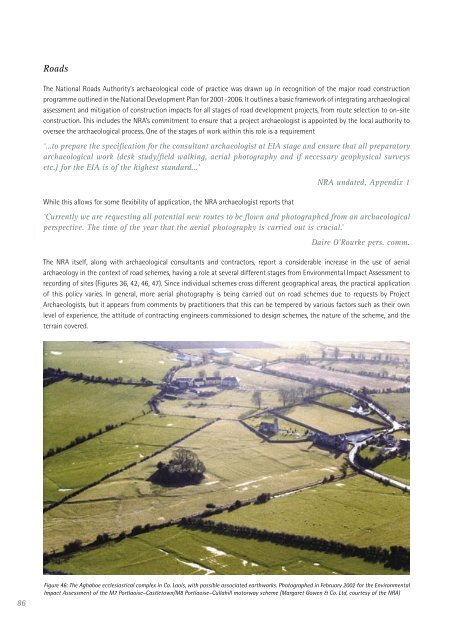
record<strong>in</strong>g of sites (Figures 36, 42, 46, 47). S<strong>in</strong>ce <strong>in</strong>dividual schemes cross different geographical areas, the practical application<br />
of this policy varies. In general, more aerial photography is be<strong>in</strong>g carried out on road schemes due to requests by Project<br />
Archaeologists, but it appears from comments by practitioners that this can be tempered by various factors such as their own<br />
level of experience, the attitude of contract<strong>in</strong>g eng<strong>in</strong>eers commissioned to design schemes, the nature of the scheme, and the<br />
terra<strong>in</strong> covered.<br />
Figure 46: <strong>The</strong> Aghaboe ecclesiastical complex <strong>in</strong> Co. Laois, with possible associated earthworks. Photographed <strong>in</strong> February 2002 for the Environmental<br />
Impact Assessment of the M7 Portlaoise–Castletown/M8 Portlaoise–Cullahill motorway scheme (Margaret Gowen & Co. Ltd, courtesy of the NRA)


