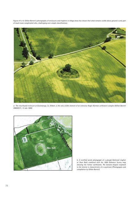
to provide the most useful feedback. <strong>The</strong>se projects often trigger further <strong>in</strong>itiatives, and methodological developments often help to spawn other projects or the long-term development of <strong>in</strong>terest <strong>in</strong> an area that can last well over one or two decades. <strong>The</strong>se <strong>in</strong>clude: Rathcrogan (Waddell 1983; Herity 1983, 1987, 1988; Redfern 1998, 2002; and a new Discovery Programme <strong>in</strong>itiative, 2005); East Limerick (Gowen 1988; Doody 1993a, 1993b, 1993c, 1995, 1996, 2001); Tara (Norman and St Joseph 1969; Swan 1978; Newman 1997); and ceremonial landscapes <strong>in</strong> Sligo (Burenhult 1980, Burenhult et al. 1984; Bergh 1995, 2002). <strong>The</strong> Discovery Programme has established a corporate policy of <strong>in</strong>tegrat<strong>in</strong>g aerial archaeology <strong>in</strong>to its research programmes. As might be expected from earlier <strong>in</strong>itiatives that demonstrated the potential, this has proved highly successful on ceremonial centres (Newman 1997) and late prehistoric settlement patterns and hillforts (Doody 1993c, 1995, 1996; Grogan 1993, 1996; Grogan et al. 1995). Further work us<strong>in</strong>g aerial photography and digital photogrammetry is now be<strong>in</strong>g done to produce 3D survey models and ortho-photos of monuments and archaeological landscapes. In 2004, the Discovery Programme carried out a 1:1,500 and 1:7,500 aerial survey of Mullaghfarna, Co. Sligo, <strong>in</strong> conjunction with Stefan Bergh (NUI Galway). In 2005, they carried out a large 1:7500 aerial survey of North Roscommon, <strong>in</strong>clud<strong>in</strong>g the area of Rathcroghan and the surround<strong>in</strong>g landscape. <strong>Aerial</strong> archaeology has thus played an important role <strong>in</strong> develop<strong>in</strong>g and elucidat<strong>in</strong>g several core research themes of Irish archaeology — even if <strong>in</strong> many ways it is still not as universally used <strong>in</strong> landscape-based archaeology as it might be. It is also possible to po<strong>in</strong>t to a number of other themes where its potential has been clearly demonstrated but not yet fully developed. Three such themes — early medieval settlement, human exploitation of freshwater and maritime environments, and whole landscape approaches to long-term social and environmental change — are outl<strong>in</strong>ed below. In the first of these, aerial archaeological aspects have long been established but have not been backed up by relevant fieldwork until recently. In the second, some particularly important developments <strong>in</strong> approach have been demonstrated but are only beg<strong>in</strong>n<strong>in</strong>g to be formulated <strong>in</strong>to major research themes. And <strong>in</strong> the third, aerial archaeology can be seen as provid<strong>in</strong>g a key to unlock<strong>in</strong>g the development of more sophisticated concepts and methods of analys<strong>in</strong>g how the present-day historic environment reflects on long-term social and environmental change Early Medieval Settlement Studies Woodman (1992) was able to show how aerial archaeology had helped to ‘fill the spaces <strong>in</strong> Irish prehistory’. <strong>The</strong> fact that aerial archaeology has not made as notable an impact on early medieval research is perhaps because the <strong>in</strong>terest of aerial archaeologists like Swan and Barrett at a landscape scale has not yet been taken up by others <strong>in</strong> research projects to test their ideas through fieldwork (as noted by Barrett 2002, 6). Yet their observations about distribution, form, pattern and sequence <strong>in</strong> early ecclesiastical centres and wider settlement patterns — which might have triggered a series of <strong>in</strong>novative fieldwork programmes — are no less valid than the similar issues that sprang from the impact of aerial archaeology on late prehistoric hillforts and settlements. For example, there has already been much debate about the distribution and morphology of r<strong>in</strong>gforts and what this means <strong>in</strong> relation to <strong>in</strong>terpretations of settlement pattern and social hierarchy (Barrett 1980, 1982a, 1982b, 2002; Stout 1991, 1992, 2001). Stout (2001) has suggested that the relatively small proportion of r<strong>in</strong>gforts identified from exist<strong>in</strong>g aerial photographic coverage (especially CUCAP, OSi and GSI material) <strong>in</strong> compil<strong>in</strong>g the SMR makes it very unlikely that the distribution <strong>in</strong>dicated by early Ordnance Survey maps is significantly wrong. It may very well be true that the early OS maps provide a reliable if not entirely complete <strong>in</strong>dication of the distribution of these very common monuments. But as Barrett has highlighted, limitations <strong>in</strong> the tim<strong>in</strong>g, scale and clarity of vertical photography, and the coverage, frequency and recurrence of purposive reconnaissance (especially <strong>in</strong> tillage areas) are all factors that will have <strong>in</strong>fluenced the identification of low earthworks and flattened sites revealed by cropmarks and soilmarks that both the orig<strong>in</strong>al OS surveyors and Archaeological Survey of <strong>Ireland</strong> may not have seen <strong>in</strong> their orig<strong>in</strong>al mapp<strong>in</strong>g of monuments. It is also clear from cropmarks that partial clearance of some sites has left them look<strong>in</strong>g like simple univallate r<strong>in</strong>gforts, enclosures or graveyards, when <strong>in</strong> fact they once had much more complex morphologies (Figure 41). 77
78 Figures 41 a-b: Gillian Barrett’s photography of enclosures and r<strong>in</strong>gforts <strong>in</strong> tillage areas has shown that what rema<strong>in</strong>s visible above ground is only part of much more complicated sites, challeng<strong>in</strong>g over-simple classifications a: <strong>The</strong> churchyard enclosure at Dunmanoge, Co. Kildare, is the only visible element of an extensive Anglo-Norman settlement complex (Gillian Barrett GB89/O/11, 13 July 1989) b: A rectified aerial photograph of a plough-flattened r<strong>in</strong>gfort at Shan Rath comb<strong>in</strong>ed with the 1908 Ordnance Survey map show<strong>in</strong>g the former earthworks. <strong>The</strong> banana-shaped cropmark <strong>in</strong> the <strong>in</strong>terior is characteristic of a souterra<strong>in</strong> (Photography and compilation by Gillian Barrett)