

Aerial Archaeology in Ireland - The Heritage Council
Aerial Archaeology in Ireland - The Heritage Council
Aerial Archaeology in Ireland - The Heritage Council

Create successful ePaper yourself
Turn your PDF publications into a flip-book with our unique Google optimized e-Paper software.
30<br />
Other material held by the GSI <strong>in</strong>cludes a set of non-stereoscopic Air Corps photos taken <strong>in</strong> the 1950s, although this is not a<br />
complete national coverage. A set of 1995 vertical photography flown at a scale of 1:5,000 was recently purchased from the OSi<br />
as the basis for 1:50,000 ortho-photography creat<strong>in</strong>g a digital mosaic map. <strong>The</strong>re is a small amount of satellite imagery for Co.<br />
Mayo. <strong>The</strong> GSI does not hold a significant set of oblique photography.<br />
<strong>The</strong> GSI collection is available for view<strong>in</strong>g purposes only; copies of photographs are available from the OSi which is currently<br />
scann<strong>in</strong>g the images for GSI. <strong>The</strong> collection can be accessed dur<strong>in</strong>g normal office hours, and there is a view<strong>in</strong>g charge of €13<br />
(Student €4). An <strong>in</strong>dex for the photographs based on the National Grid is also available. A search service is provided, with simple<br />
stereoscopes available to assist view<strong>in</strong>g. <strong>The</strong> majority of users are archaeologists. Although there are no records of actual figures,<br />
this pattern of use is reported to be very marked, and is borne out by comments from archaeologists themselves. Several have<br />
noted the relative ease of access to the GSI collection, compared with the OSi. Many archaeologists also ask to use the Air Corps<br />
photos taken <strong>in</strong> the 1950s, although that set is not complete national coverage.<br />
<strong>The</strong> GSI is responsible for the Irish National Seabed Survey data, <strong>in</strong>clud<strong>in</strong>g airborne lidar surveys (Section 3.4) off the west coast<br />
of <strong>Ireland</strong>. Three areas have been surveyed: Mulroy Bay, Northern Donegal; Clew Bay, Co. Mayo; and Killalla Bay, Co. Mayo. While<br />
the data has been used primarily for bathymetric purposes, field boundaries and disused jetties are clearly visible <strong>in</strong> the imagery.<br />
For Phase 2 of the Survey, key bays and priority areas around <strong>Ireland</strong> have been targeted for <strong>in</strong>tegrated survey work. <strong>The</strong> areas<br />
have been selected after <strong>in</strong>tensive consultation among the various stakeholders, <strong>in</strong>clud<strong>in</strong>g the Underwater <strong>Archaeology</strong> Unit of<br />
DoEHLG.<br />
Air Corps, Baldonnell<br />
<strong>The</strong> Air Corps holds a significant collection of historic aerial photography, virtually all dat<strong>in</strong>g from before the early 1970s when<br />
responsibility for civil air photography was passed to the OSi. Reconnaissance for these purposes ceased <strong>in</strong> about 1978, though<br />
reconnaissance and tra<strong>in</strong><strong>in</strong>g for military purposes cont<strong>in</strong>ue.<br />
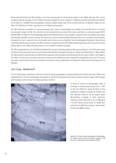
In terms of vertical air photography, there is<br />
coverage of various areas dat<strong>in</strong>g from c. 1951<br />
to the mid 1970s (e.g. Figure 8). None of this<br />
represents complete coverage of <strong>Ireland</strong>, and<br />
the emphasis tends to be on coastal areas.<br />
Nevertheless, coverage is fairly extensive,<br />
totall<strong>in</strong>g around 200 rolls of up to 200 @ 9<br />
x 9 <strong>in</strong>ch frames, mostly taken at 10,500 feet<br />
and some at 5,400 feet, mostly <strong>in</strong> stereoscopic<br />
format with 60% overlap.<br />
Figure 8: Air Corps vertical photograph of Newgrange,<br />
Co. Meath, taken dur<strong>in</strong>g low-angled sunlight on 20<br />
December 1972 (Government Stationery Office)


