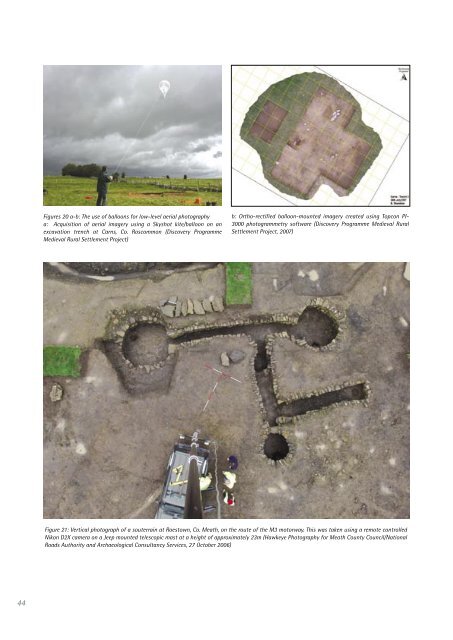
Satellites <strong>The</strong> potential for us<strong>in</strong>g satellite imagery <strong>in</strong> archaeology has been recognised for over ten years (Fowler 1996), though it is only <strong>in</strong> the last five years that the availability and cost of high-resolution imagery has made it an obvious alternative to aircraft-based vertical photography. As discussed below, and as with conventional aircraft, satellites can be used to provide imagery based on optical (visible light, near <strong>in</strong>frared, shortwave <strong>in</strong>frared), thermal and radio wavelengths. A range of satellites is used to provide such imagery. <strong>The</strong>y are generally positioned at altitudes of 400km to 700km <strong>in</strong> polar, sun synchronous orbit, with a typical repeat overpass of one to 16 days. Depend<strong>in</strong>g on the particular satellite and the services offered, they can provide imagery at low resolution (c. 1km or more), medium resolution (c. 100m to 1km), high resolution (c. 5m to 100m) and very high resolution (c. 5m or less). Although medium resolution can provide valuable general vegetational mapp<strong>in</strong>g, it is the high (and more particularly very high) resolution systems that are of most value for archaeological applications, as outl<strong>in</strong>ed below. Available High Resolution Satellite Imagery (Source: M. Critchley, ERA-Maptec Ltd) Satellite Resolution (m) Bands Type QuickBird colour <strong>in</strong>frared (pan merge) 0.60m NIR, R, G Colour QuickBird multispectral 2.44m NIR, R, G, B Colour IKONOS colour <strong>in</strong>frared (pan merge) 1m NIR, R, G Colour IKONOS multispectral 4m NIR, R, G, B Colour Spot 5 (pan merge) 2.5m NIR, R, G Colour Spot 5 (pan merge) 5m NIR, R, G Colour Spot 5 (multispectral) 10m SWIR, NIR, R, G Colour Landsat ETM 15m SWIR, NIR, R, G Colour Radarsat 10m C-Band Radar ASTER 18m/30m SWIR, NIR, TIR Colour, <strong>The</strong>rmal Abbreviations for wavebands: SWIR = shortwave band <strong>in</strong>frared, NIR = near <strong>in</strong>frared, TIR = thermal <strong>in</strong>frared; R = red; G = green; B = blue; C-Band = C-band radar As noted earlier, the Google Earth <strong>in</strong>ternet site now offers basic cover of most of the world, but with blocks of much higher quality resolution of about 1-2m which can be of some use archaeologically. For <strong>Ireland</strong>, this imagery now covers major population centres and various other areas and swathes of landscape <strong>in</strong>clud<strong>in</strong>g, for example, a significant part of Kerry. It compares well with relatively high-level vertical photography. Very Low-level <strong>Aerial</strong> Imagery At the most detailed, low-level end of the scale, the use of remote-controlled cameras (less often other scanners) mounted on small, unmanned aircraft (i.e. balloons, kites and radio controlled model aircraft) or on top of manoeuverable poles and masts has been an established, though not ma<strong>in</strong>stream, form of aerial archaeological photography s<strong>in</strong>ce the 1970s. This cont<strong>in</strong>ues to be developed by some practitioners, and is becom<strong>in</strong>g <strong>in</strong>creas<strong>in</strong>gly ref<strong>in</strong>ed as the technology of remote controlled photography and control of m<strong>in</strong>iature fly<strong>in</strong>g platforms improves (e.g. Knisely-Marpole 2001 on kites; Schönherr 2001 on model aircraft). For example, <strong>in</strong> recent years, the Discovery Programme has been mak<strong>in</strong>g good use of both balloons and telescopic masts (Figures 19, 20), though others said they had experimented with kites for site photography without much success. 43
44 Figures 20 a-b: <strong>The</strong> use of balloons for low-level aerial photography a: Acquisition of aerial imagery us<strong>in</strong>g a Skyshot kite/balloon on an excavation trench at Carns, Co. Roscommon (Discovery Programme Medieval Rural Settlement Project) b: Ortho-rectified balloon-mounted imagery created us<strong>in</strong>g Topcon PI- 3000 photogrammetry software (Discovery Programme Medieval Rural Settlement Project, 2007) Figure 21: Vertical photograph of a souterra<strong>in</strong> at Roestown, Co. Meath, on the route of the M3 motorway. This was taken us<strong>in</strong>g a remote controlled Nikon D2X camera on a Jeep mounted telescopic mast at a height of approximately 23m (Hawkeye Photography for Meath County <strong>Council</strong>/National Roads Authority and Archaeological Consultancy Services, 27 October 2006)