

Aerial Archaeology in Ireland - The Heritage Council
Aerial Archaeology in Ireland - The Heritage Council
Aerial Archaeology in Ireland - The Heritage Council

You also want an ePaper? Increase the reach of your titles
YUMPU automatically turns print PDFs into web optimized ePapers that Google loves.
50<br />
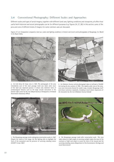
3.4 Conventional Photography: Different Scales and Approaches<br />
Different scales and types of aerial imagery, together with different land uses, light<strong>in</strong>g conditions and viewpo<strong>in</strong>ts, all affect how<br />
useful both historical and recent photography can be for different purposes (e.g. Figures 24, 27, 28). In this section, some of the<br />
pros and cons of different k<strong>in</strong>ds of imagery for some common uses are discussed.<br />
Figures 27 a-d: Comparative viewpo<strong>in</strong>ts, land use, scales and light<strong>in</strong>g conditions <strong>in</strong> historic and recent aerial photography at Newgrange, Co. Meath<br />
<strong>in</strong> the Boyne Valley<br />
a: An Irish Army Air Corps view <strong>in</strong> 1924. This photograph of the area<br />
immediately west of the ma<strong>in</strong> passage tomb was taken when most<br />
of the land was improved pasture. It shows only <strong>in</strong>dist<strong>in</strong>ct h<strong>in</strong>ts of<br />
archaeological features such as the large circular monument <strong>in</strong> the<br />
bottom right corner by the river (Royal Society of Antiquaries of <strong>Ireland</strong>/<br />
Government Stationery Office)<br />
c: <strong>The</strong> Newgrange passage tomb undergo<strong>in</strong>g conservation works <strong>in</strong> 1967.<br />
Despite the clarity of the image, the flat light<strong>in</strong>g fails to highlight the<br />
form of the monument and the presence of surviv<strong>in</strong>g stand<strong>in</strong>g stones<br />
(CUCAP 15 July 1967)<br />
b: An Ordnance Survey vertical photograph taken at altitude of 20,000<br />
feet dur<strong>in</strong>g the dry summer of 1995. This slightly wider view of the area,<br />
now more <strong>in</strong>tensively farmed for arable crops, <strong>in</strong>cludes Newgrange itself<br />
and shows numerous cropmarks, <strong>in</strong>clud<strong>in</strong>g a much clearer impression of<br />
the monument by the river (Ordnance Survey <strong>Ireland</strong>)<br />
d: <strong>The</strong> Newgrange passage tomb after conservation work. This view<br />
taken almost at right-angles to morn<strong>in</strong>g sunlight makes the most of the<br />
contrasts of light and shade to reveal the form of the mound and the<br />
surviv<strong>in</strong>g stand<strong>in</strong>g stones (Department of the Environment, <strong>Heritage</strong> and<br />
Local Government)


