

Aerial Archaeology in Ireland - The Heritage Council
Aerial Archaeology in Ireland - The Heritage Council
Aerial Archaeology in Ireland - The Heritage Council

You also want an ePaper? Increase the reach of your titles
YUMPU automatically turns print PDFs into web optimized ePapers that Google loves.
46<br />
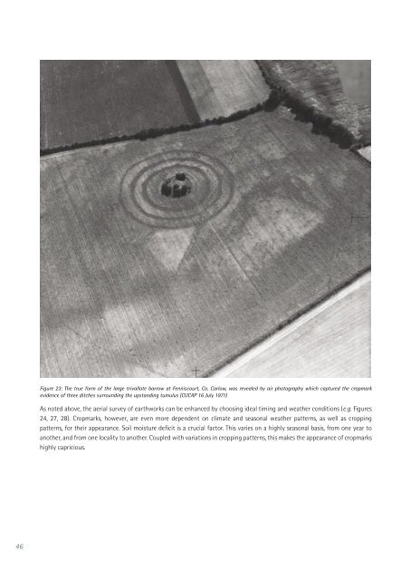
Figure 23: <strong>The</strong> true form of the large trivallate barrow at Fenniscourt, Co. Carlow, was revealed by air photography which captured the cropmark<br />
evidence of three ditches surround<strong>in</strong>g the upstand<strong>in</strong>g tumulus (CUCAP 16 July 1971)<br />
As noted above, the aerial survey of earthworks can be enhanced by choos<strong>in</strong>g ideal tim<strong>in</strong>g and weather conditions (e.g. Figures<br />
24, 27, 28). Cropmarks, however, are even more dependent on climate and seasonal weather patterns, as well as cropp<strong>in</strong>g<br />
patterns, for their appearance. Soil moisture deficit is a crucial factor. This varies on a highly seasonal basis, from one year to<br />
another, and from one locality to another. Coupled with variations <strong>in</strong> cropp<strong>in</strong>g patterns, this makes the appearance of cropmarks<br />
highly capricious.


