

Aerial Archaeology in Ireland - The Heritage Council
Aerial Archaeology in Ireland - The Heritage Council
Aerial Archaeology in Ireland - The Heritage Council

Create successful ePaper yourself
Turn your PDF publications into a flip-book with our unique Google optimized e-Paper software.
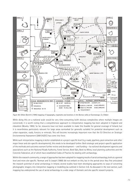
Figure 40: Gillian Barrett’s (1995) mapp<strong>in</strong>g of topography, cropmarks and locations <strong>in</strong> the Barrow valley at Dunmanoge, Co. Kildare<br />
While do<strong>in</strong>g this on a national scale would be very time-consum<strong>in</strong>g (with obvious complexities where multiple images are<br />
concerned), it is worth not<strong>in</strong>g that a comprehensive approach to <strong>in</strong>terpretative mapp<strong>in</strong>g has been adopted <strong>in</strong> England and<br />
elsewhere (Bewley 1995). So far, resources have not been available to make this feasible for general coverage of <strong>Ireland</strong>, but<br />
it is nevertheless particularly relevant for large areas earmarked (or generally suitable) for potential development such as<br />
urban expansion, roads, forestry or m<strong>in</strong>erals. This will become <strong>in</strong>creas<strong>in</strong>gly important now that the EU Directive on Strategic<br />
Environmental Assessment (2001/42/EC) has come <strong>in</strong>to force.<br />
While such <strong>in</strong>terpretative mapp<strong>in</strong>g is better established at a project-specific level (e.g. roads, pipel<strong>in</strong>es, peat extraction and other<br />
major l<strong>in</strong>ear and site-specific developments), this needs to be developed further. Both strategic and project-specific application<br />
of the methods and outcomes warrant further review and development — and fund<strong>in</strong>g — by national development agencies and<br />
associations such as the National Roads Authority, Forest Service, Bord Gáis, Bord na Móna, local plann<strong>in</strong>g authorities and the<br />
Concrete Federation, all of which have established Codes of Practice for deal<strong>in</strong>g with archaeology.<br />
With<strong>in</strong> the research community, a range of approaches has been adopted for mapp<strong>in</strong>g results of aerial archaeology, both at a general<br />
level and more site-specific. Norman and St Joseph (1969) did not embark on this, but <strong>in</strong> the period s<strong>in</strong>ce they first articulated<br />
the research potential of aerial archaeology <strong>in</strong> <strong>Ireland</strong>, several studies have been develop<strong>in</strong>g approaches to ways of convert<strong>in</strong>g<br />
photographic imagery <strong>in</strong>to <strong>in</strong>terpretive mapp<strong>in</strong>g or modell<strong>in</strong>g (as outl<strong>in</strong>ed <strong>in</strong> Section 3.4). As discussed <strong>in</strong> the next section, such<br />
mapp<strong>in</strong>g has underp<strong>in</strong>ned the use of aerial archaeology <strong>in</strong> a wide range of thematic and site-specific research projects.<br />
75


