

Aerial Archaeology in Ireland - The Heritage Council
Aerial Archaeology in Ireland - The Heritage Council
Aerial Archaeology in Ireland - The Heritage Council

You also want an ePaper? Increase the reach of your titles
YUMPU automatically turns print PDFs into web optimized ePapers that Google loves.
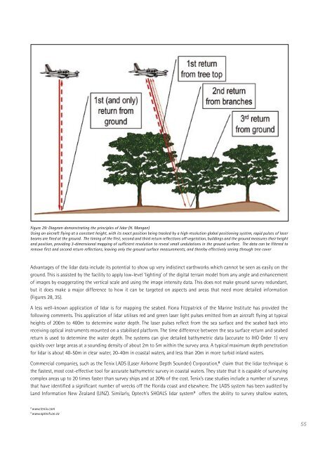
Figure 29: Diagram demonstrat<strong>in</strong>g the pr<strong>in</strong>ciples of lidar (H. Mangan)<br />
Us<strong>in</strong>g an aircraft fly<strong>in</strong>g at a constant height, with its exact position be<strong>in</strong>g tracked by a high resolution global position<strong>in</strong>g system, rapid pulses of laser<br />
beams are fired at the ground. <strong>The</strong> tim<strong>in</strong>g of the first, second and third return reflections off vegetation, build<strong>in</strong>gs and the ground measures their height<br />
and position, provid<strong>in</strong>g 3-dimensional mapp<strong>in</strong>g of sufficient resolution to reveal small undulations <strong>in</strong> the ground surface. <strong>The</strong> data can be filtered to<br />
remove first and second return reflections, leav<strong>in</strong>g only the ground surface measurements, and thereby effectively see<strong>in</strong>g through tree cover<br />
Advantages of the lidar data <strong>in</strong>clude its potential to show up very <strong>in</strong>dist<strong>in</strong>ct earthworks which cannot be seen as easily on the<br />
ground. This is assisted by the facility to apply low-level ‘light<strong>in</strong>g’ of the digital terra<strong>in</strong> model from any angle and enhancement<br />
of images by exaggerat<strong>in</strong>g the vertical scale and us<strong>in</strong>g the image <strong>in</strong>tensity data. This does not make ground survey redundant,<br />
but it does make a major difference to how it can be targeted on aspects and areas that need more detailed <strong>in</strong>formation<br />
(Figures 28, 35).<br />
A less well-known application of lidar is for mapp<strong>in</strong>g the seabed. Fiona Fitzpatrick of the Mar<strong>in</strong>e Institute has provided the<br />
follow<strong>in</strong>g comments. This application of lidar utilises red and green laser light pulses emitted from an aircraft fly<strong>in</strong>g at typical<br />
heights of 200m to 400m to determ<strong>in</strong>e water depth. <strong>The</strong> laser pulses reflect from the sea surface and the seabed back <strong>in</strong>to<br />
receiv<strong>in</strong>g optical <strong>in</strong>struments mounted on a stabilised platform. <strong>The</strong> time difference between the sea surface return and seabed<br />
return is used to determ<strong>in</strong>e the water depth. <strong>The</strong> systems can give detailed bathymetric data (accurate to IHO Order 1) very<br />
quickly over large areas at a sound<strong>in</strong>g density of about 2m to 5m with<strong>in</strong> the survey area. A typical maximum depth penetration<br />
for lidar is about 40-50m <strong>in</strong> clear water, 20-40m <strong>in</strong> coastal waters, and less than 20m <strong>in</strong> more turbid <strong>in</strong>land waters.<br />
Commercial companies, such as the Tenix LADS (Laser Airborne Depth Sounder) Corporation, 8 claim that the lidar technique is<br />
the fastest, most cost-effective tool for accurate bathymetric survey <strong>in</strong> coastal waters. <strong>The</strong>y state that it is capable of survey<strong>in</strong>g<br />
complex areas up to 20 times faster than survey ships and at 20% of the cost. Tenix’s case studies <strong>in</strong>clude a number of surveys<br />
that have identified a significant number of wrecks off the Florida coast and elsewhere. <strong>The</strong> LADS system has been audited by<br />
Land Information New Zealand (LINZ). Similarly, Optech’s SHOALS lidar system 9 offers the ability to survey shallow waters,<br />
8 www.tenix.com<br />
9 www.optech.on.ca<br />
55


