

Aerial Archaeology in Ireland - The Heritage Council
Aerial Archaeology in Ireland - The Heritage Council
Aerial Archaeology in Ireland - The Heritage Council

Create successful ePaper yourself
Turn your PDF publications into a flip-book with our unique Google optimized e-Paper software.
22<br />
As a means of discover<strong>in</strong>g archaeological rema<strong>in</strong>s, especially those which are unlikely to be revealed by other methods, aerial<br />
archaeology has a fundamental role to play. While much can be achieved through aerial archaeology as a method of work<strong>in</strong>g <strong>in</strong> its<br />
own right, it is often seen as complementary to other archaeological and historical techniques of exam<strong>in</strong><strong>in</strong>g the past. It is arguably<br />
most powerful as a tool to be comb<strong>in</strong>ed with other forms of archaeological work, and <strong>in</strong>deed with other discipl<strong>in</strong>es of history,<br />
geography and environmental studies. Much aerial archaeology can be seen not as a specifically archaeological science, but as part<br />
of a wider process of multi-discipl<strong>in</strong>ary <strong>in</strong>terpretation of landscape which comb<strong>in</strong>es geology, topography, ecology and archaeology<br />
to understand natural and anthropogenic forces of change (Mitchell and Ryan 1990; Aalen, Whelan and Stout 1997).<br />
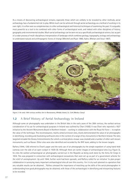
Figure 2: An early 19th-century artillery fort <strong>in</strong> Reenavanny, Whiddy Island, Co. Cork (Markus Casey)<br />
1.2 A Brief History of <strong>Aerial</strong> <strong>Archaeology</strong> <strong>in</strong> <strong>Ireland</strong><br />
Although some air photography was undertaken <strong>in</strong> the British Isles <strong>in</strong> the early years of the 20th century, the earliest serious<br />
consideration of its use for archaeological purposes <strong>in</strong> <strong>Ireland</strong> was outl<strong>in</strong>ed by Chart (1930). It was Chart who reported a 1927<br />
<strong>in</strong>itiative by the Ancient Monuments Board <strong>in</strong> Northern <strong>Ireland</strong> — work<strong>in</strong>g <strong>in</strong> collaboration with the Royal Air Force — to explore<br />
the value of the technique. This reconnaissance, ma<strong>in</strong>ly aimed at known sites, clearly demonstrated the value of air photography<br />
<strong>in</strong> identify<strong>in</strong>g, record<strong>in</strong>g and illustrat<strong>in</strong>g earthwork sites <strong>in</strong> the context of a range of key monuments <strong>in</strong> Northern <strong>Ireland</strong>. <strong>The</strong> sites<br />
targeted <strong>in</strong>cluded the Dorsey Entrenchments (for which a vertical photo-mosaic was created) and a number of other well-known<br />
monuments, such as Navan. Other sites were also identified and recorded by the RAF team, add<strong>in</strong>g to the known targets.<br />
Raftery (1944, 120) referred to Chart’s paper and the early use of air photography by the simple expedient of us<strong>in</strong>g hand-held<br />
cameras over the side of an open cockpit <strong>in</strong> 1929-30. Although there are earlier images of archaeological sites (e.g. Figure 3),<br />
he cites the earliest archaeological air photography carried out <strong>in</strong> the Republic as be<strong>in</strong>g work done by the Army Air Corps <strong>in</strong><br />
1934. This was prepared <strong>in</strong> connection with archaeological excavations that were set up as part of a government scheme for<br />
the relief of unemployment. Up until 1944, further work had been sporadic, and Raftery called for an <strong>in</strong>itiative ‘to plan proper<br />
collaboration <strong>in</strong> survey<strong>in</strong>g many important archaeological sites all over this country. For it is by such planned co-operation that<br />
any valuable results can be obta<strong>in</strong>ed…’. Raftery stressed the importance of match<strong>in</strong>g up the skills of the aerial photographer <strong>in</strong><br />
understand<strong>in</strong>g how good photographs may be obta<strong>in</strong>ed, with those of the archaeologist <strong>in</strong> identify<strong>in</strong>g and <strong>in</strong>terpret<strong>in</strong>g features<br />
to be recorded.


