

Aerial Archaeology in Ireland - The Heritage Council
Aerial Archaeology in Ireland - The Heritage Council
Aerial Archaeology in Ireland - The Heritage Council

Create successful ePaper yourself
Turn your PDF publications into a flip-book with our unique Google optimized e-Paper software.
96<br />
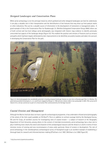
Designed Landscapes and Conservation Plans<br />
While aerial archaeology is not the pr<strong>in</strong>cipal means by which parkland and other designed landscapes can best be understood,<br />
it can play a valuable role <strong>in</strong> their <strong>in</strong>terpretation and the identification of lost features that may show up from pasture marks<br />
or other <strong>in</strong>dications. This can be a valuable source of <strong>in</strong>formation <strong>in</strong> the development of restoration or management plans. A<br />
good example of this is the Conservation Plan for Russborough, Co. Wicklow (Integrated Conservation Group 2005) where use<br />
of both vertical and low-level oblique aerial photography was <strong>in</strong>tegrated with historic map evidence to identify previously<br />
unrecorded lost aspects of the landscape design (Figure 53). This enabled the position and rema<strong>in</strong>s of features such as terraces<br />
and paths which had been largely obliterated by later improvements to be identified, accurately located, and taken <strong>in</strong>to account<br />
<strong>in</strong> develop<strong>in</strong>g the Conservation Plan for the park.<br />
Figure 53: <strong>Aerial</strong> photography has considerable potential <strong>in</strong> locat<strong>in</strong>g designed landscape features as seen here at Russborough Park, Co. Wicklow. <strong>The</strong><br />
pond and associated terrac<strong>in</strong>g (a, b, c, d, e and f) were mapped by Rocque <strong>in</strong> 1760 and were clearly visible <strong>in</strong> low spr<strong>in</strong>g light <strong>in</strong> 2001. (<strong>The</strong> survey by M.<br />
Gowen & Co. Ltd was carried out as part of a Conservation Plan commissioned by the <strong>Heritage</strong> <strong>Council</strong>)<br />
Coastal Erosion and Management<br />
Although the Mar<strong>in</strong>e Institute does not have a specific archaeological programme, it has undertaken <strong>in</strong>frared aerial photography<br />
of the whole of the Irish coast( available on CD-Rom 21 ). This is <strong>in</strong> addition to vertical coverage held by the Geological Survey,<br />
OSi and Air Corps, all excellent sources for <strong>in</strong>vestigat<strong>in</strong>g rates of coastal erosion — a subject of research at the Geography<br />
Department of Cork University, among others. In the context of <strong>in</strong>tertidal environments, aerial archaeology has a clear role to<br />
play <strong>in</strong> def<strong>in</strong><strong>in</strong>g more clearly the extent and character of the archaeological resource and the threat to it, both <strong>in</strong> terms of more<br />
<strong>in</strong>tensive review of exist<strong>in</strong>g and new reconnaissance of areas under particular threat of erosion or development. <strong>The</strong> role of<br />
aerial archaeology <strong>in</strong> the <strong>in</strong>terdiscipl<strong>in</strong>ary archaeological survey of Strangford Lough is an excellent example of establish<strong>in</strong>g a<br />
thorough basis for research and <strong>in</strong>formed decision-mak<strong>in</strong>g (O’Sullivan et al. 1997; McErlean et al. 2002 Figure 81)<br />
21 http://www.mar<strong>in</strong>e.ie/publicationsandlibrary


