

Aerial Archaeology in Ireland - The Heritage Council
Aerial Archaeology in Ireland - The Heritage Council
Aerial Archaeology in Ireland - The Heritage Council

Create successful ePaper yourself
Turn your PDF publications into a flip-book with our unique Google optimized e-Paper software.
84<br />
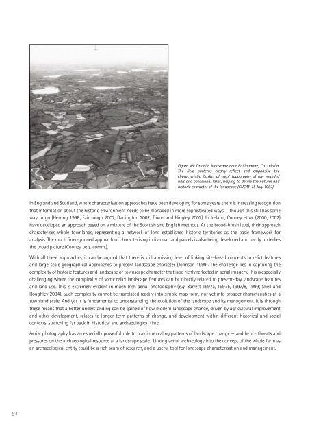
Figure 45: Druml<strong>in</strong> landscape near Ball<strong>in</strong>amore, Co. Leitrim.<br />
<strong>The</strong> field patterns clearly reflect and emphasise the<br />
characteristic ‘basket of eggs’ topography of low rounded<br />
hills and occasional lakes, help<strong>in</strong>g to def<strong>in</strong>e the natural and<br />
historic character of the landscape (CUCAP 15 July 1967)<br />
In England and Scotland, where characterisation approaches have been develop<strong>in</strong>g for some years, there is <strong>in</strong>creas<strong>in</strong>g recognition<br />
that <strong>in</strong>formation about the historic environment needs to be managed <strong>in</strong> more sophisticated ways — though this still has some<br />
way to go (Herr<strong>in</strong>g 1998; Fairclough 2002, Darl<strong>in</strong>gton 2002; Dixon and H<strong>in</strong>gley 2002). In <strong>Ireland</strong>, Cooney et al. (2000, 2002)<br />
have developed an approach based on a mixture of the Scottish and English methods. At the broad-brush level, their approach<br />
characterises whole townlands, represent<strong>in</strong>g a network of long-established historic territories as the basic framework for<br />
analysis. <strong>The</strong> much f<strong>in</strong>er-gra<strong>in</strong>ed approach of characteris<strong>in</strong>g <strong>in</strong>dividual land parcels is also be<strong>in</strong>g developed and partly underlies<br />
the broad picture (Cooney pers. comm.).<br />
With all these approaches, it can be argued that there is still a miss<strong>in</strong>g level of l<strong>in</strong>k<strong>in</strong>g site-based concepts to relict features<br />
and large-scale geographical approaches to present landscape character (Johnson 1999). <strong>The</strong> challenge lies <strong>in</strong> captur<strong>in</strong>g the<br />
complexity of historic features and landscape or townscape character that is so richly reflected <strong>in</strong> aerial imagery. This is especially<br />
challeng<strong>in</strong>g where the complexity of some relict landscape features can be directly related to present-day landscape features<br />
and land use. This is extremely evident <strong>in</strong> much Irish aerial photography (e.g. Barrett 1997a, 1997b, 1997/8, 1999; Shell and<br />
Roughley 2004). Such complexity cannot be translated readily <strong>in</strong>to simple map form, nor yet <strong>in</strong>to broader characteristics at a<br />
townland scale. And yet it is fundamental to understand<strong>in</strong>g the evolution of the landscape and its management. It is through<br />
these means that a better understand<strong>in</strong>g can be ga<strong>in</strong>ed of how modern landscape change, driven by agricultural improvement<br />
and other development, relates to longer term patterns of change, and development with<strong>in</strong> different historical and social<br />
contexts, stretch<strong>in</strong>g far back <strong>in</strong> historical and archaeological time.<br />
<strong>Aerial</strong> photography has an especially powerful role to play <strong>in</strong> reveal<strong>in</strong>g patterns of landscape change — and hence threats and<br />
pressures on the archaeological resource at a landscape scale. L<strong>in</strong>k<strong>in</strong>g aerial archaeology <strong>in</strong>to the concept of the whole farm as<br />
an archaeological entity could be a rich seam of research, and a useful tool for landscape characterisation and management.


