

Aerial Archaeology in Ireland - The Heritage Council
Aerial Archaeology in Ireland - The Heritage Council
Aerial Archaeology in Ireland - The Heritage Council

You also want an ePaper? Increase the reach of your titles
YUMPU automatically turns print PDFs into web optimized ePapers that Google loves.
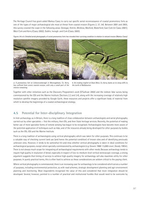
<strong>The</strong> <strong>Heritage</strong> <strong>Council</strong> has grant-aided Markus Casey to carry out specific aerial reconnaissance of coastal promontory forts as<br />
one of the types of major archaeological site most at threat from coastal erosion (Figures 2, 37, 54). Between 2001 and 2003,<br />
this survey covered the coast <strong>in</strong> the follow<strong>in</strong>g areas: Donegal, Antrim, Wicklow, Wexford, Waterford; East Cork (<strong>in</strong> Casey 2001);<br />
West Cork and Kerry (Casey 2002); Dubl<strong>in</strong>, Iveragh. and Cork (Casey 2003).<br />
Figures 54 a-b: Detailed aerial photography of costal promontory forts has recorded their surviv<strong>in</strong>g condition <strong>in</strong> relation to natural erosion (Markus Casey)<br />
a: A promontory fort at Lisheencankeragh <strong>in</strong> Meenogahane, Co. Kerry,<br />
has suffered from severe coastal erosion, with only a small part of the<br />
<strong>in</strong>terior rema<strong>in</strong><strong>in</strong>g<br />
b: An erod<strong>in</strong>g r<strong>in</strong>gfort at Doon West, Co. Kerry, backs on to steep cliffs to<br />
the north of Ballybunion<br />
Together with other <strong>in</strong>itiatives such as the Discovery Programme’s work (O’Sullivan 2002) and the <strong>in</strong>shore lidar survey be<strong>in</strong>g<br />
commissioned by the GSI and the Mar<strong>in</strong>e Institute (Sections 2.2 and 3.4), along with the <strong>in</strong>creas<strong>in</strong>g coverage of relatively high<br />
resolution satellite imagery provided by Google Earth, these resources and projects offer a significant body of material from<br />
which to develop the beg<strong>in</strong>n<strong>in</strong>gs of a coastal archaeological strategy.<br />
4.5 Potential for Inter-discipl<strong>in</strong>ary Integration<br />
In Irish archaeology as <strong>in</strong> Brita<strong>in</strong>, there is a long tradition of close collaboration between archaeologists and aerial photography<br />
carried out by other specialists — first the military, then OSi, and then State heritage services. Recently, the potential of mak<strong>in</strong>g<br />
better use of more specialist forms of remote sens<strong>in</strong>g has begun to be recognised. Archaeologists have become more aware of<br />
the potential application of techniques such as lidar, and of the resources already be<strong>in</strong>g developed for other purposes by bodies<br />
such as the OSi, GSI and the Mar<strong>in</strong>e Institute.<br />
<strong>The</strong>re is a long tradition of archaeologists us<strong>in</strong>g vertical photography which was taken for other purposes. This cont<strong>in</strong>ues to be<br />
a valuable way of check<strong>in</strong>g current land use (and hence the potential condition) of known sites and of identify<strong>in</strong>g previously<br />
unknown ones. However, it tends to be somewhat hit-and-miss whether vertical photography is taken <strong>in</strong> ideal conditions for<br />
archaeological purposes, except where specially commissioned by archaeologists (e.g. Gowen 1988 1:5,000 cover; Doody 1993c).<br />
<strong>The</strong>re is not always much scope for <strong>in</strong>tegrat<strong>in</strong>g all archaeological requirements with other needs. Because archaeology tends to<br />
require high quality <strong>in</strong> resolution of detail, especially <strong>in</strong> respect of low-to-medium-level vertical stereoscopic coverage, a strong<br />
argument suggests that tim<strong>in</strong>g of surveys to achieve high-quality imagery for archaeology will also maximise utility for other<br />
purposes. In purely practical terms, this is often hard to achieve as these considerations are seldom critical to the pay<strong>in</strong>g client.<br />
Where vertical photography is commissioned, there is an <strong>in</strong>creas<strong>in</strong>g case for archaeology to be considered which serves a number<br />
of purposes, <strong>in</strong>clud<strong>in</strong>g environmental protection, as with road schemes, strategic development plann<strong>in</strong>g and agri-environment<br />
plann<strong>in</strong>g and monitor<strong>in</strong>g. Most respondents recognised the value of this and considered that more <strong>in</strong>tegration should be<br />
developed. Several, however, po<strong>in</strong>ted to a number of practical and <strong>in</strong>stitutional hurdles that would need to be overcome by<br />
97


