

Aerial Archaeology in Ireland - The Heritage Council
Aerial Archaeology in Ireland - The Heritage Council
Aerial Archaeology in Ireland - The Heritage Council

You also want an ePaper? Increase the reach of your titles
YUMPU automatically turns print PDFs into web optimized ePapers that Google loves.
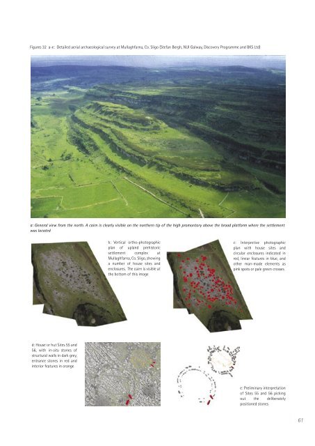
Figures 32 a-e: Detailed aerial archaeological survey at Mullaghfarna, Co. Sligo (Stefan Bergh, NUI Galway, Discovery Programme and BKS Ltd)<br />
a: General view from the north. A cairn is clearly visible on the northern tip of the high promontory above the broad platform where the settlement<br />
was located<br />
d: House or hut Sites 55 and<br />
56, with <strong>in</strong>-situ stones of<br />
structural walls <strong>in</strong> dark grey,<br />
entrance stones <strong>in</strong> red and<br />
<strong>in</strong>terior features <strong>in</strong> orange<br />
b: Vertical ortho-photographic<br />
plan of upland prehistoric<br />
settlement complex at<br />
Mullaghfarna, Co. Sligo, show<strong>in</strong>g<br />
a number of house sites and<br />
enclosures. <strong>The</strong> cairn is visible at<br />
the bottom of this image<br />
c: Interpretive photographic<br />
plan with house sites and<br />
circular enclosures <strong>in</strong>dicated <strong>in</strong><br />
red, l<strong>in</strong>ear features <strong>in</strong> blue, and<br />
other man-made elements as<br />
p<strong>in</strong>k spots or pale green crosses<br />
e: Prelim<strong>in</strong>ary <strong>in</strong>terpretation<br />
of Sites 55 and 56 pick<strong>in</strong>g<br />
out the deliberately<br />
positioned stones<br />
61


