

Geologic Studies in Alaska by the U.S. Geological Survey, 1992
Geologic Studies in Alaska by the U.S. Geological Survey, 1992
Geologic Studies in Alaska by the U.S. Geological Survey, 1992

You also want an ePaper? Increase the reach of your titles
YUMPU automatically turns print PDFs into web optimized ePapers that Google loves.
4 GEOLOGIC STUDIES IN ALASKA BY THE U.S. GEOLOGICAL SURVEY, <strong>1992</strong><br />
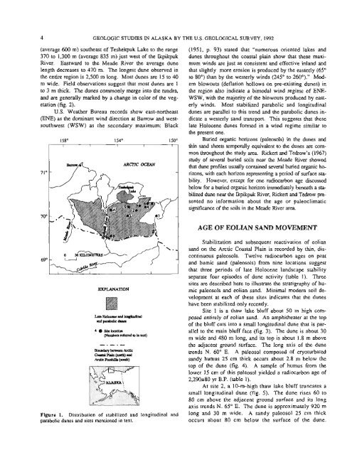
(average 600 m) sou<strong>the</strong>ast of Teshekpuk Lake to <strong>the</strong> range<br />
370 to 1,300 m (average 835 m) just west of <strong>the</strong> Ikpikpuk<br />
River. Eastward to <strong>the</strong> Meade River <strong>the</strong> average dune<br />
length decreases to 470 m. The longest dune observed <strong>in</strong><br />
<strong>the</strong> entire region is 2,500 m long. Most dunes are 15 to 40<br />
m wide. Field observations suggest that most dunes are 1<br />
to 3 m thick. The dunes commonly merge <strong>in</strong>to <strong>the</strong> tundra,<br />
and are generally marked <strong>by</strong> a change <strong>in</strong> color of <strong>the</strong> veg-<br />
etation (fig. 2).<br />
U.S. Wea<strong>the</strong>r Bureau records show east-nor<strong>the</strong>ast<br />
(ENE) as <strong>the</strong> dom<strong>in</strong>ant w<strong>in</strong>d direction at Barrow and west-<br />
southwest (WSW) as <strong>the</strong> secondary maximum: Black<br />
- 7 ARCTIC OCEAN<br />
EXPLANATION<br />
4 Site location<br />
~ ~ r to <strong>in</strong> text) c M<br />
Boundary between Ardic<br />
coostrlp1.<strong>in</strong>(north)uNl<br />
Atcric Foothillr (d)<br />
Figure 1. Distribution of stabilized and longitud<strong>in</strong>al and<br />
parabolic dunes and sites mentioned <strong>in</strong> text.<br />
(1951, p. 93) stated that "numerous oriented lakes and<br />
dunes throughout <strong>the</strong> coastal pla<strong>in</strong> show that <strong>the</strong>se maxi-<br />
mum w<strong>in</strong>ds are just as consistent and effective <strong>in</strong>land and<br />
that slightly more erosion is produced <strong>by</strong> <strong>the</strong> easterly (65"<br />
to 80") than <strong>by</strong> <strong>the</strong> westerly w<strong>in</strong>ds (245" to 260°)." Mod-<br />
em blowouts (deflation hollows on pre-exist<strong>in</strong>g dunes) <strong>in</strong><br />
<strong>the</strong> region also <strong>in</strong>dicate a bimodal w<strong>in</strong>d regime of ENE-<br />
WSW, with <strong>the</strong> majority of <strong>the</strong> blowouts produced <strong>by</strong> east-<br />
erly w<strong>in</strong>ds. Most stabilized parabolic and longitud<strong>in</strong>al<br />
dunes are parallel to this trend and <strong>the</strong> parabolic dunes <strong>in</strong>-<br />
dicate a westerly sand transport. This suggests that <strong>the</strong>se<br />
late Holocene dunes formed <strong>in</strong> a w<strong>in</strong>d regime similar to<br />
<strong>the</strong> present one.<br />
Buried organic horizons (paleosols) <strong>in</strong> <strong>the</strong> dunes and<br />
th<strong>in</strong> sand sheets temporally equivalent to <strong>the</strong> dunes are com-<br />
mon throughout <strong>the</strong> study area. Rickert and Tedrow's (1967)<br />
study of several buried soils near <strong>the</strong> Meade River showed<br />
that dune profiles usually conta<strong>in</strong>ed several buried organic ho-<br />
rizons, with each horizon represent<strong>in</strong>g a period of surface sta-<br />
bility. However, except for one radiocarbon age discussed<br />
below for a buried organic horizon immediately beneath a sta-<br />
bilized dune near <strong>the</strong> lkpikpuk River, Rickert and Tedrow pre-<br />
sented no <strong>in</strong>formation about <strong>the</strong> age or paleoclimatic<br />
significance of <strong>the</strong> soils <strong>in</strong> <strong>the</strong> Meade River area.<br />
AGE OF EOLIAN SAND MOVEMENT<br />
Stabilization and subsequent reactivation of eolian<br />
sand on <strong>the</strong> Arctic Coastal Pla<strong>in</strong> is recorded <strong>by</strong> th<strong>in</strong>, discont<strong>in</strong>uous<br />
paleosols. Twelve radiocarbon ages on peat<br />
and humic sand (paleosols) from n<strong>in</strong>e locations suggest<br />
that three periods of late Holocene landscape stability<br />
separate four episodes of dune activity (table 1). Three<br />
sites are described here to illustrate <strong>the</strong> stratigraphy of hurnic<br />
paleosols and eolian sand. M<strong>in</strong>imal modern soil development<br />
at each of <strong>the</strong>se sites <strong>in</strong>dicates that <strong>the</strong> dunes<br />
have been stabilized only recently.<br />
Site 1 is a thaw lake bluff about 50 m high composed<br />
entirely of eolian sand. An amphi<strong>the</strong>ater at <strong>the</strong> top<br />
of <strong>the</strong> bluff cuts <strong>in</strong>to a small longitud<strong>in</strong>al dune that is parallel<br />
to <strong>the</strong> ma<strong>in</strong> bluff face (fig. 3). The dune is about 30<br />
m wide and 480 m long, and its top is about 1.8 m above<br />
<strong>the</strong> adjacent ground surface. The long axis of <strong>the</strong> dune<br />
trends N. 60" E. A paleosol composed of cryoturbated<br />
sandy humus 25 cm thick occurs about 2.8 m below <strong>the</strong><br />
top of <strong>the</strong> dune (fig. 4). A sample of humus from <strong>the</strong><br />
lower 15 cm of this paleosol yielded a radiocarbon age of<br />
2,290~80 yr B.P. (table 1).<br />
At site 2, a 10-m-high thaw lake bluff truncates a<br />
small longitud<strong>in</strong>al dune (fig. 5). The dune rises 60 to<br />
80 cm above <strong>the</strong> adjacent ground surface and its long<br />
axis trends N. 65" E. The dune is approximately 920 m<br />
long and 30 m wide. A sandy paleosol 25 cm thick<br />
occurs about 80 cm below <strong>the</strong> surface of <strong>the</strong> dune.


