

Geologic Studies in Alaska by the U.S. Geological Survey, 1992
Geologic Studies in Alaska by the U.S. Geological Survey, 1992
Geologic Studies in Alaska by the U.S. Geological Survey, 1992

You also want an ePaper? Increase the reach of your titles
YUMPU automatically turns print PDFs into web optimized ePapers that Google loves.
RESERVOIR FRAMEWORK ARCHITECTURE, CLAMGULCHIAN TYPE SECTION, STERLING FORMATION 123<br />
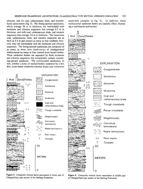
siltstone, and (3) coal, carbonaceous shale, and tonste<strong>in</strong>-<br />
facies associations (fig. 5). The f<strong>in</strong><strong>in</strong>g-upward sandstones,<br />
which average 20 m <strong>in</strong> thickness, are <strong>in</strong>terbedded with<br />
mudstone and siltstone sequences that average 9.5 m <strong>in</strong><br />
thickness, and with coal, carbonaceous shale, and tonste<strong>in</strong><br />
sequences that average 2.8 m <strong>in</strong> thickness. The lowermost<br />
coal, carbonaceous shale, and tonste<strong>in</strong> sequences are as<br />
thick as 5.2 m and conta<strong>in</strong> as many as four coalbeds; how-<br />
ever, <strong>the</strong>y are <strong>in</strong>terbedded with <strong>the</strong> mudstone and siltstone<br />
sequences. The f<strong>in</strong><strong>in</strong>g-upward sandstones are composed of<br />
as many as three tiers (multistory) of amalgamated<br />
multiscoured (as many as four <strong>in</strong>ternal scour bases) bodies.<br />
These sandstone bodies are separated <strong>by</strong> thick mudstone<br />
and siltstone sequences that occasionally conta<strong>in</strong> coarsen-<br />
<strong>in</strong>g-upward sandstone. The multiscoured sandstones, <strong>in</strong><br />
turn, exhibit a series of stacked bodies separated <strong>by</strong> a few<br />
th<strong>in</strong>, scour-based mudstone-siltstone lenses (see lowermost<br />
- .-<br />
+<br />
EXPLANATION<br />
V)<br />
I Mud I l~andl~ebble Conglomerate<br />
Sandstone<br />
Siltstone<br />
Mudstone<br />
Coal and<br />
carbonaceous shale<br />
- ---a - Trough crossbeds<br />
d<br />
& Megaforesets<br />
4 l<br />
Convolute<br />
lam<strong>in</strong>ations<br />
-& - Ripple lam<strong>in</strong>ations<br />
--<br />
' 30<br />
AA Root marks<br />
T Tonste<strong>in</strong><br />
METERS<br />
sandstone complex <strong>in</strong> fig. 5). In addition, <strong>the</strong>se<br />
multiscoured sandstone bodies are laterally offset, display-<br />
<strong>in</strong>g a multilateral architecture.<br />
.-<br />
I Mud /Sand~ Pebble<br />
-<br />
- 4<br />
EXPLANATION<br />
Conglomerate<br />
Sandstone<br />
Siltstone<br />
Mudstone<br />
Coal and<br />
carbonaceous shale<br />
v'- -<br />
- b- Trough crossbeds<br />
@ Planar crossbeds<br />
Megaforesets<br />
Convolute<br />
W<br />
-<br />
lam<strong>in</strong>ations<br />
- Ripple lam<strong>in</strong>ations<br />
- /-.,<br />
Ah Root marks<br />
T<br />
- 30<br />
Tonste<strong>in</strong><br />
METERS<br />
Figure 5. Composite vertical facies association <strong>in</strong> lower part of Figure 6. Composite vertical facies association <strong>in</strong> middle part<br />
Clamgulchian type section of <strong>the</strong> Sterl<strong>in</strong>g Formation. of Clarngulchian type section of <strong>the</strong> Sterl<strong>in</strong>g Formation.


