

Geologic Studies in Alaska by the U.S. Geological Survey, 1992
Geologic Studies in Alaska by the U.S. Geological Survey, 1992
Geologic Studies in Alaska by the U.S. Geological Survey, 1992

You also want an ePaper? Increase the reach of your titles
YUMPU automatically turns print PDFs into web optimized ePapers that Google loves.
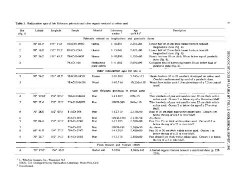
Table 1. Radiocarbon ages of late Holocene paleosols and o<strong>the</strong>r organic material <strong>in</strong> eolian sand<br />
Site Latitude Longitude Sample Material Laboratory Age<br />
(fig. 1) number ' (yr B.P.)~<br />
Paleosols related to longitud<strong>in</strong>al and parabolic dunes<br />
-<br />
1 70" 03.9' 153" 31.6' 78ACrlI-099D Humus I-10,891 2,290280<br />
2 70" 16.8' 152" 55.2' 82ACr-224A Humus I-13,041 2,420280<br />
3 70" 26.2' 151" 45.5' 78ACrII-045F Humus I-10,890 1,100+80<br />
3 79ACr- 106 Herbaceous I- 1 1,602 3,690290<br />
plant debris<br />
Older radiocarbon ages for site 3<br />
Description<br />
- - -<br />
Lower half of 25 cm thick humic horizon beneath<br />
longitud<strong>in</strong>al dune (fig. 4).<br />
Lower half of 25 cm thick humic horizon beneath<br />
longitud<strong>in</strong>al dune (fig. 6).<br />
Humic horizon 10 cm thick 50 cm below top of parabolic<br />
dune (fig. 8).<br />
Collapsed nest of burrow<strong>in</strong>g rodent 30 cm below base of<br />
parabolic dune (fig. 8).<br />
3 70" 26.2' 151" 45.5' 78ACrII-045D Humus I- 10,889 5,7452115 Humic horizon 10 to 20 cm thick developed on eolian sand.<br />
Overla<strong>in</strong> and truncated <strong>by</strong> sand of a parabolic dune.<br />
3 78ACrII-045B 1 Wood I-10,716 10,2202 150 Wood from eolian sand 1.5 m above base of a 7.5 m coastal<br />
bluff.<br />
Late Holocene paleosols <strong>in</strong> eolian sand<br />
- - - - -- - --<br />
4 70" 22.65' 152" 09.2' 78ACrII-046D Peat 1-1 1,489 890275 Th<strong>in</strong> <strong>in</strong>terbeds of peat and sand <strong>in</strong> zone 20 cm thick with<strong>in</strong><br />
eolian sand. Occurs 3 m below top of a 16 m river bluff.<br />
5 70" 22.4' 153" 12.2' 77ACrII-002D Peat USGS-380 9402 110 Th<strong>in</strong> <strong>in</strong>terbeds of peat and sand <strong>in</strong> zone 25 cm thick with<strong>in</strong><br />
eolian sand. Occurs 2 m below <strong>the</strong> top of a 27 m river<br />
bluff.<br />
6 70" 26.8' 152" 09.0' 81ACr-006 Peat I-12,179 2,130290 Base of 30 cm thick peat with<strong>in</strong> eolian sand. Occurs 1 m<br />
below <strong>the</strong> top of a 6.4 m river bluff.<br />
6 8 1ACr-006 Peat USGS-1381 2,210250 As above.<br />
7 70" 04.4' 15 1" 22.9' 82ACr-074G Peat I-13,075 2,200280 Peat 7 to 15 cm thick with<strong>in</strong> eolian sand. Occurs 0.5 m<br />
below <strong>the</strong> top of a 25 m river bluff.<br />
7 75ACr-022 Peat USGS-I 85 2,280250 As above.<br />
8 69" 41.8' 154" 27.2' 79ACr-074T Peat I- 1 1,920 2,480280 Peat 20 to 30 cm thick with<strong>in</strong> eolian sand. Occurs 1 m<br />
below <strong>the</strong> top of a 23 m river bluff.<br />
9 70" 25.7' 152" 34.2' 81ACr-005B Peat I-12,178 2,500280 Peat about 5 cm thick with<strong>in</strong> eolian sand. Occurs 1 m below<br />
<strong>the</strong> top of a 3 m lake bluff.<br />
From Rickert and Tedrow (1967)<br />
A 70" 17.0' 154" 43.0' Buried soil I- 1004 3,8402 140 A buried organic horizon beneath a stabilized dune (p. 258-<br />
I-, Teledyne Isotopes, Inc., Westwood, N.J.<br />
USGS-, U.S. <strong>Geologic</strong>al <strong>Survey</strong> Radiocarbon Laboratory, Menlo Park, Calif.<br />
Uncalibrated.


