

Geologic Studies in Alaska by the U.S. Geological Survey, 1992
Geologic Studies in Alaska by the U.S. Geological Survey, 1992
Geologic Studies in Alaska by the U.S. Geological Survey, 1992

Create successful ePaper yourself
Turn your PDF publications into a flip-book with our unique Google optimized e-Paper software.
LITHOFACIES AND CONODONTS OF CARBONIFEROUS STRATA IN THE IVOTUK HILLS, BROOKS RANGE<br />
LITHOFACIES<br />
KAYAK SHALE<br />
About 45 m of shale, mudstone, silty shale, and<br />
dolostone assigned <strong>by</strong> Mart<strong>in</strong> (1970) to <strong>the</strong> Kayak Shale is<br />
exposed beneath <strong>the</strong> Lisburne Group along Otuk Creek.<br />
The base of <strong>the</strong> section is concealed and is probably a<br />
thrust fault (C.G. Mull, written commun., <strong>1992</strong>). The sec-<br />
tion consists chiefly of fissile, black shale and blocky<br />
mudstone, locally yellow- to red-wea<strong>the</strong>r<strong>in</strong>g. Some<br />
samples, ma<strong>in</strong>ly <strong>in</strong> <strong>the</strong> lower third of <strong>the</strong> exposure, conta<strong>in</strong><br />
m<strong>in</strong>or amounts of detrital quartz silt. Dark-gray, reddish-<br />
brown-wea<strong>the</strong>r<strong>in</strong>g concretions, lenses, and layers of dolo-<br />
mitic mudstone to dolostone make up 10 to 20 percent of<br />
<strong>the</strong> lower half of <strong>the</strong> section (fig. 4A). Concretions reach<br />
20 cm <strong>in</strong> diameter; lenses and layers range from 2 to 30<br />
cm thick and display discont<strong>in</strong>uous, wispy lam<strong>in</strong>ae. In<br />
th<strong>in</strong> section, concretions consist of 25 to nearly 100 per-<br />
cent dolomite crystals, 6 to 60 pn (rarely, to 200 pn) <strong>in</strong><br />
diameter, <strong>in</strong> a noncalcareous mudstone matrix (fig. 4B).<br />
Lam<strong>in</strong>ae reflect variations <strong>in</strong> <strong>the</strong> concentration of dolomite<br />
versus mud.<br />
Spiculitic layers a few centimeters thick make up<br />
about 10 percent of <strong>the</strong> section. Some samples consist of<br />
calcareous spicules (fig. 4C), or a mixture of calcareous<br />
and siliceous spicules, <strong>in</strong> a mudstone matrix; o<strong>the</strong>r samples<br />
conta<strong>in</strong> only siliceous spicules <strong>in</strong> a matrix of microcrystal-<br />
l<strong>in</strong>e chert. Spicules are typically well aligned and may be<br />
concentrated <strong>in</strong>to parallel or cross lam<strong>in</strong>ae; some spicules<br />
have been partly or completely replaced <strong>by</strong> pyrite.<br />
Medium- to dark-gray, orange- to reddish-brown-<br />
wea<strong>the</strong>r<strong>in</strong>g, dolomitic bioclastic packstone occurs near <strong>the</strong><br />
base and middle of <strong>the</strong> section <strong>in</strong> beds and lenses 10 cm to<br />
1.7 m thick (fig. 40). Bedd<strong>in</strong>g surfaces are densely<br />
bioturbated; some beds are graded and display wispy<br />
parallel lam<strong>in</strong>ae. Clasts range from less than 1 mm to sev-<br />
eral centimeters <strong>in</strong> diameter; matrix consists of calcareous<br />
and noncalcareous mud. Most clasts are bioclasts, chiefly<br />
cr<strong>in</strong>oid ossicles, brachiopods, and rare solitary corals (fig. 40-<br />
F). Many bioclasts are broken and abraded, and some have<br />
bored and micritized rims. Five to 25 percent phosphatic<br />
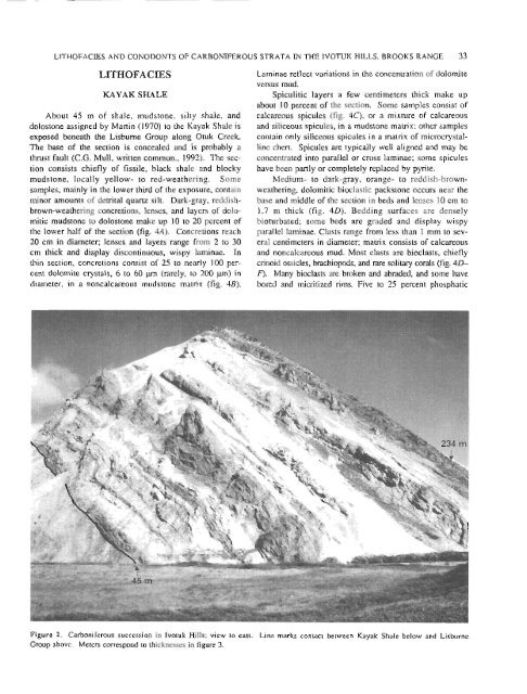
Figure 2. Carboniferous succession <strong>in</strong> Ivotuk Hills; view to east. L<strong>in</strong>e marks contact between Kayak Shale below and Lisbume<br />
Group above. Meters correspond to thicknesses <strong>in</strong> figure 3.<br />
33


