

Geologic Studies in Alaska by the U.S. Geological Survey, 1992
Geologic Studies in Alaska by the U.S. Geological Survey, 1992
Geologic Studies in Alaska by the U.S. Geological Survey, 1992

Create successful ePaper yourself
Turn your PDF publications into a flip-book with our unique Google optimized e-Paper software.
DEEP-WATER LITHOFACIES AND CONODONT FAUNAS OF THE LISBURNE GROUP, BROOKS RANGE 13<br />
13) established <strong>by</strong> Mull and o<strong>the</strong>rs (1982). In <strong>the</strong> study<br />
area, <strong>the</strong> Kuna is at most 70 m thick; it depositionally<br />
overlies <strong>the</strong> Kayak Shale and generally underlies f<strong>in</strong>e-<br />
gra<strong>in</strong>ed sedimentary rocks of <strong>the</strong> Etivluk Group. Locally,<br />
particularly <strong>in</strong> <strong>the</strong> eastern part of <strong>the</strong> study area, <strong>the</strong> upper<br />
contact of <strong>the</strong> Kuna is a fault.<br />
As orig<strong>in</strong>ally def<strong>in</strong>ed <strong>by</strong> Mull and o<strong>the</strong>rs (1982), <strong>the</strong><br />
Kuna Formation consists of black carbonaceous shale,<br />
black chert, f<strong>in</strong>e-gra<strong>in</strong>ed limestone, and dolostone. In <strong>the</strong><br />
study area, some Kuna sections consist chiefly of black,<br />
carbonaceous, noncalcareous shale; such sections are gen-<br />
erally poorly exposed and <strong>in</strong>clude only m<strong>in</strong>or amounts of<br />
carbonate rocks and (or) chert (fig. 3A). These shale-rich<br />
outcrops are commonest <strong>in</strong> <strong>the</strong> western half of <strong>the</strong> Howard<br />
Pass quadrangle (fig. 2).<br />
Most sections of <strong>the</strong> Kuna Formation exam<strong>in</strong>ed <strong>in</strong> this<br />
study, however, consist primarily of siliceous mudstone<br />
with subord<strong>in</strong>ate (5-20 percent) shaly beds or part<strong>in</strong>gs<br />
(fig. 3B). Mudstone beds are even to irregular and 2-20<br />
cm thick; shale <strong>in</strong>tervals are generally a few centimeters or<br />
less, but may be as much as 10 cm thick. The thicker<br />
beds, called chert <strong>by</strong> some previous workers (for example,<br />
Mull and o<strong>the</strong>rs, 1982), are siliceous mudstone, not true<br />
chert; <strong>the</strong>y have an earthy ra<strong>the</strong>r than vitreous luster and<br />
do not fracture conchoidally. In th<strong>in</strong> section, <strong>the</strong>y conta<strong>in</strong><br />
abundant biosiliceous material, chiefly sponge spicules but<br />
also subord<strong>in</strong>ate radiolarians, <strong>in</strong> a matrix of organic-rich<br />
mud (fig. 30. Some mudstone layers have been locally<br />
STUDY<br />
gOw AREA<br />
-- ---<br />
silicified; silica for this process may have come, at least <strong>in</strong><br />
part, from dissolution and remobilization of <strong>the</strong> bio-<br />
siliceous component of <strong>the</strong>se rocks.<br />
F<strong>in</strong>e lam<strong>in</strong>ation is <strong>the</strong> only sedimentary structure vis-<br />
ible <strong>in</strong> most outcrops of <strong>the</strong> Kuna Formation (fig. 30).<br />
Lam<strong>in</strong>ae consist of local concentrations of sand- to silt-<br />
sized clasts, mostly of mudstone, or alternat<strong>in</strong>g concentra-<br />
tions of sponge spicules and mud (fig. 3E). Most<br />
lam<strong>in</strong>ated <strong>in</strong>tervals probably represent distal turbidites, or<br />
lags left <strong>by</strong> bottom currents. But cyclic changes <strong>in</strong> pro-<br />
ductivity and (or) detrital <strong>in</strong>flux <strong>in</strong>to <strong>the</strong> Kuna bas<strong>in</strong>(s)<br />
could also have played a role <strong>in</strong> form<strong>in</strong>g some lam<strong>in</strong>ae.<br />
Preservation of <strong>the</strong>se lam<strong>in</strong>ae, as well as <strong>the</strong> appar-<br />
ently high organic content of much of <strong>the</strong> Kuna Formation,<br />
suggest that anoxic or dysaerobic bottom-water conditions<br />
prevailed dur<strong>in</strong>g its deposition. Some <strong>in</strong>tervals with<strong>in</strong> <strong>the</strong><br />
Kuna are burrowed, however, so oxygen levels at <strong>the</strong> sedi-<br />
ment-water <strong>in</strong>terface were locally or periodically high<br />
enough to support a bottom fauna. Bioturbated <strong>in</strong>tervals<br />
(fig. 3F) are most common <strong>in</strong> <strong>the</strong> easternmost exposures of<br />
<strong>the</strong> Kuna <strong>in</strong> <strong>the</strong> study area. Burrows are round to ovoid <strong>in</strong><br />
cross section, about 0.5-1 cm <strong>in</strong> diameter, and generally<br />
richer <strong>in</strong> siliceous bioclasts than <strong>the</strong> surround<strong>in</strong>g mudstone.<br />
Carbonate forms 30 percent or less of most outcrops<br />
of <strong>the</strong> Kuna Formation that we studied. Carbonate occurs<br />
as concretions, 4-85 cm <strong>in</strong> diameter (fig. 4A), or more<br />
cont<strong>in</strong>uous layers a few millimeters to 30 cm thick (fig.<br />
4B). Primary calcareous material, such as obvious<br />
f ALASKA 1<br />
0 100 200 KILOMETERS<br />
I I<br />
/ I I I<br />
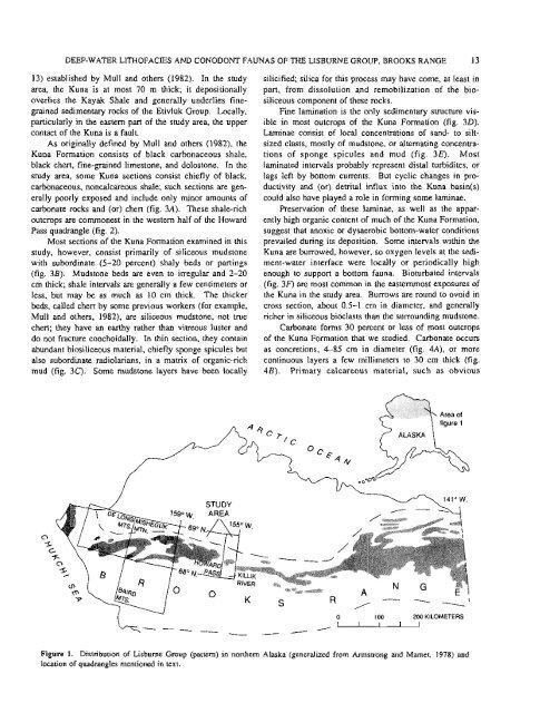
Figure 1. Distribution of Lisburne Group (pattern) <strong>in</strong> nor<strong>the</strong>rn <strong>Alaska</strong> (generalized from Armstrong and Mamet, 1978) and<br />
location of quadrangles mentioned <strong>in</strong> text.


