

Geologic Studies in Alaska by the U.S. Geological Survey, 1992
Geologic Studies in Alaska by the U.S. Geological Survey, 1992
Geologic Studies in Alaska by the U.S. Geological Survey, 1992

Create successful ePaper yourself
Turn your PDF publications into a flip-book with our unique Google optimized e-Paper software.
152 GEOLOGIC STUDIES IN ALASKA BY THE U.S. GEOLOGICAL SURVEY, <strong>1992</strong><br />
crystallization, <strong>the</strong> release of magmatic fluids affected <strong>the</strong><br />
wall rocks around <strong>the</strong> pluton.<br />
The felsite dikes <strong>in</strong> <strong>the</strong> study area are subvertical and<br />
generally strike northwest-sou<strong>the</strong>ast, but <strong>the</strong> strikes range<br />
from east-west to north-south (fig. 11). The dikes near<br />
Unakwik Inlet with K-feldspar and quartz phenocrysts<br />
strike east-west (fig. 1 I). Pegmatite and autobrecciated<br />
granitic dikes associated with <strong>the</strong> Granite Cove pluton<br />
strike northwest-sou<strong>the</strong>ast (fig. 11). As mentioned earlier,<br />
a dike <strong>in</strong> doma<strong>in</strong> F is slightly boud<strong>in</strong>aged with subvertical<br />
boud<strong>in</strong> axes. This is <strong>the</strong> only <strong>in</strong>dication of ductile defor-<br />
mation of any of <strong>the</strong> dikes.<br />
FAULTS<br />
Steeply dipp<strong>in</strong>g brittle faults with quartz ve<strong>in</strong>s, brecci-<br />
ated wall rock, and clayey gouge less than several centi-<br />
meters thick are found throughout <strong>the</strong> study area. The<br />
orientation of <strong>the</strong>se faults is roughly <strong>the</strong> same <strong>in</strong> all do-<br />
ma<strong>in</strong>s, and thus we consider <strong>the</strong>m toge<strong>the</strong>r. A plot of all<br />
known fault orientations and <strong>the</strong>ir sense of offset (fig. 12),<br />
where it was determ<strong>in</strong>ed, demonstrates that (1) <strong>the</strong> most<br />
common fault orientation is north-south- or NNW-SSE-<br />
strik<strong>in</strong>g and subvertically dipp<strong>in</strong>g, and (2) most of <strong>the</strong>se<br />
faults (18 of 24 with known offset) are strike-slip faults.<br />
North-south-strik<strong>in</strong>g s<strong>in</strong>istral-slip faults cut <strong>the</strong> Cedar Bay<br />
pluton, and north-south-strik<strong>in</strong>g dextral- and s<strong>in</strong>istral-slip<br />
faults cut <strong>the</strong> Granite Cove pluton. It is puzzl<strong>in</strong>g that both<br />
dextral and s<strong>in</strong>istral faults have approximately <strong>the</strong> same<br />
orientation but <strong>the</strong> opposite sense of slip.<br />
Abundant geomorphic l<strong>in</strong>eaments cross <strong>the</strong> study area,<br />
and many of <strong>the</strong>se have a north-south or NNW-SSE trend.<br />
L<strong>in</strong>eaments with <strong>the</strong> same orientation cut <strong>the</strong> M<strong>in</strong>ers Bay,<br />
Cedar Bay, and Terentiev Lake plutons. The Cedar Bay<br />
pluton, <strong>in</strong> particular, has a strong NNW-SSE-strik<strong>in</strong>g set.<br />
The fractures are subvertical, as <strong>in</strong>dicated <strong>by</strong> <strong>the</strong>ir l<strong>in</strong>ear<br />
trace across topography. The strikes of fractures <strong>in</strong> <strong>the</strong><br />
sou<strong>the</strong>rn half of <strong>the</strong> study area were measured from<br />
Condon and Cass" (1958) compilation of l<strong>in</strong>ear geologic<br />
features <strong>in</strong> western Pr<strong>in</strong>ce William Sound (fig. 13). The<br />
l<strong>in</strong>eaments strike north-south to NNW-SSE, similar to <strong>the</strong><br />
Figure 7. Eight localities with<strong>in</strong> study area show quasi-fold<br />
geometry, which at 1:63,360-map scale show apparent fann<strong>in</strong>g<br />
of bedd<strong>in</strong>g planes, although fac<strong>in</strong>g direction rema<strong>in</strong>s <strong>the</strong> same.<br />
This figure shows <strong>in</strong> cross-sectional view our use of <strong>the</strong> term<br />
"quasi-fold" and <strong>the</strong> two types of geometry observed <strong>in</strong> <strong>the</strong><br />
field. Arrows show upward-fac<strong>in</strong>g direction of rocks.<br />
most common orientation of faults, and thus we <strong>in</strong>terpret<br />
<strong>the</strong> l<strong>in</strong>eaments as fractures that are probably strike-slip<br />
faults with m<strong>in</strong>or offset.<br />
The amount of offset on <strong>the</strong>se north-south to NNW-<br />
SSE-strik<strong>in</strong>g brittle faults probably is not significant be-<br />
cause no pluton contact or stratigraphic horizon is offset<br />
along <strong>the</strong>m. However, <strong>the</strong>re may be approximately 11 km<br />
of dextral map separation along a (ENE-WSW-strik<strong>in</strong>g)<br />
splay of <strong>the</strong> Contact fault (W<strong>in</strong>kler, <strong>1992</strong>) that runs be-<br />
tween M<strong>in</strong>ers Bay and Kad<strong>in</strong> Lake (fig. 2). Conglomerate<br />
south of M<strong>in</strong>ers Lake (fig. 2) strikes <strong>in</strong>to <strong>the</strong> M<strong>in</strong>ers Bay-<br />
Kad<strong>in</strong> Lake splay, and <strong>the</strong> closest conglomerate on <strong>the</strong><br />
north side of <strong>the</strong> splay is located near <strong>the</strong> Columbia Red<br />
Metals prospect (CRM, fig. 2) between Kad<strong>in</strong> Lake and<br />
<strong>the</strong> Columbia Glacier. This fault also truncates <strong>the</strong> -35-Ma<br />
M<strong>in</strong>ers Bay pluton. Traverses across <strong>the</strong> M<strong>in</strong>ers Bay-<br />
Kad<strong>in</strong> Lake splay of <strong>the</strong> Contact fault did not reveal areas<br />
of high ductile stra<strong>in</strong>. In conglomerate adjacent to <strong>the</strong><br />
fault, clasts were not noticeably flattened. No brittle faults<br />
were observed <strong>in</strong> <strong>the</strong> vic<strong>in</strong>ity of <strong>the</strong> fault at ei<strong>the</strong>r <strong>the</strong> east<br />
or west end of Kad<strong>in</strong> Lake, but numerous subvertical l<strong>in</strong>-<br />
eaments along <strong>the</strong> splay <strong>in</strong>dicate that <strong>the</strong>re has been some<br />
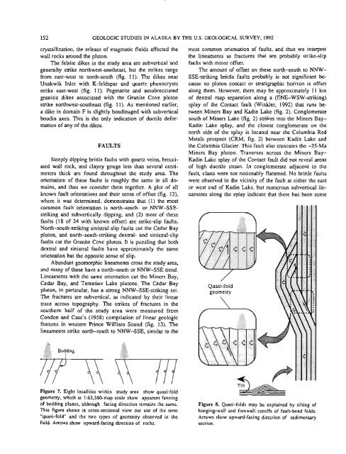
Figure 8. Quasi-folds may be expla<strong>in</strong>ed <strong>by</strong> tilt<strong>in</strong>g of<br />
hang<strong>in</strong>g-wall and footwall cutoffs of fault-bend folds.<br />
Arrows show upward-fac<strong>in</strong>g direction of sedimentary<br />
section.


