Geologic Studies in Alaska by the U.S. Geological Survey, 1992
Geologic Studies in Alaska by the U.S. Geological Survey, 1992
Geologic Studies in Alaska by the U.S. Geological Survey, 1992
You also want an ePaper? Increase the reach of your titles
YUMPU automatically turns print PDFs into web optimized ePapers that Google loves.
LATE HOLOCENE LONGITUDINAL AND PARABOLIC DUNES IN NORTHERN ALASKA 9<br />
Ages <strong>in</strong> radiocarbon years (table 1) were converted to calen-<br />
dar yr B.P. (table 2) us<strong>in</strong>g <strong>the</strong> calibration curve of Stuiver and<br />
Reimer (1986). From one to several calibrated ages are pos-<br />
sible for each radiocarbon age, because <strong>the</strong> measured radiocar-<br />
bon activity of <strong>the</strong> sample may <strong>in</strong>tersect <strong>the</strong> calibration curve<br />
<strong>in</strong> one or more places. Values shown <strong>in</strong> paren<strong>the</strong>ses <strong>in</strong> table 2<br />
are <strong>the</strong> calibration curve <strong>in</strong>tersections, and <strong>the</strong> limit<strong>in</strong>g values<br />
shown without paren<strong>the</strong>ses represent <strong>in</strong>tersections of <strong>the</strong> ra-<br />
diocarbon analytical error with <strong>the</strong> calibration curve and its<br />
analytical error.<br />
PALEOCLIMATIC SIGNIFICANCE<br />
Eolian sand on <strong>the</strong> Arctic Coastal Pla<strong>in</strong> is highly<br />
susceptible to w<strong>in</strong>d erosion if <strong>the</strong> stabiliz<strong>in</strong>g tundra vegeta-<br />
tion is absent or disturbed <strong>by</strong> natural or anthropogenic pro-<br />
cesses. Over <strong>the</strong> past 20,000 years, climatic change has<br />
caused repeated stabilization of <strong>the</strong> dunes and sand sheets<br />
(Carter and o<strong>the</strong>rs, 1984; Carter, <strong>in</strong> press). Stabilization of<br />
<strong>the</strong> eolian surfaces occurred when climatic conditions were<br />
relatively moist and allowed <strong>the</strong> growth of stabiliz<strong>in</strong>g veg-<br />
etation, whereas reactivation of eolian activity occurred<br />
when surface conditions were relatively dry. Alternat<strong>in</strong>g<br />
periods of eolian sand transport and soil formation thus<br />
record changes <strong>in</strong> surface-moisture conditions, and dat<strong>in</strong>g<br />
<strong>the</strong>se periods provides <strong>in</strong>formation that can be <strong>in</strong>tegrated<br />
with o<strong>the</strong>r proxy climatic <strong>in</strong>formation to produce a more<br />
complete record of climatic change.<br />
The time of late Holocene dune reactivation follow-<br />
<strong>in</strong>g middle Holocene development of organic soils is not<br />
precisely known. Two radiocarbon ages for <strong>the</strong> uppermost<br />
parts of <strong>the</strong> middle Holocene paleosols are calibrated to<br />
5.9 and 5.1 ka ( Carter, <strong>in</strong> press). The th<strong>in</strong>, discont<strong>in</strong>uous<br />
paleosols associated with <strong>the</strong> late Holocene eolian sand <strong>in</strong>-<br />
dicate that dur<strong>in</strong>g most of <strong>the</strong> late Holocene, dry surface<br />
METERS<br />
8 -<br />
conditions promoted eolian sand transport and dune forma-<br />
tion. The calibrated radiocarbon ages reported here for<br />
<strong>the</strong>se paleosols (fig. 9) suggest that <strong>the</strong>se generally dry<br />
surface conditions were <strong>in</strong>terrupted <strong>by</strong> at least three rela-<br />
tively moist <strong>in</strong>tervals of soil formation and relative land-<br />
scape stability.<br />
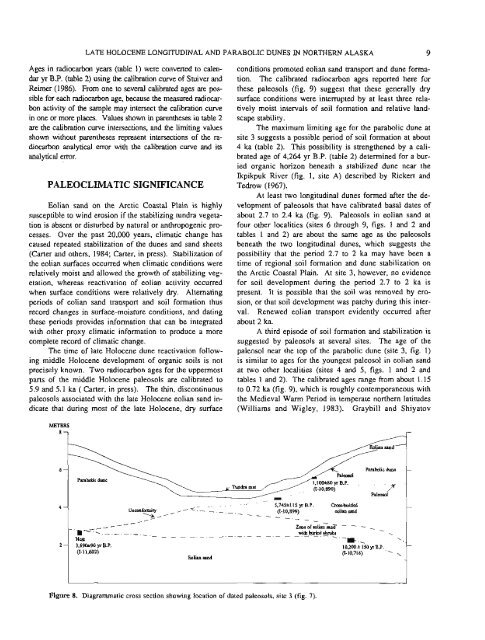
The maximum limit<strong>in</strong>g age for <strong>the</strong> parabolic dune at<br />
site 3 suggests a possible period of soil formation at about<br />
4 ka (table 2). This possibility is streng<strong>the</strong>ned <strong>by</strong> a cali-<br />
brated age of 4,264 yr B.P. (table 2) determ<strong>in</strong>ed for a bur-<br />
ied organic horizon beneath a stabilized dune near <strong>the</strong><br />
Ikpikpuk River (fig. 1, site A) described <strong>by</strong> Rickert and<br />
Tedrow (1 967).<br />
At least two longitud<strong>in</strong>al dunes formed after <strong>the</strong> de-<br />
velopment of paleosols that have calibrated basal dates of<br />
about 2.7 to 2.4 ka (fig. 9). Paleosols <strong>in</strong> eolian sand at<br />
four o<strong>the</strong>r localities (sites 6 through 9, figs. 1 and 2 and<br />
tables 1 and 2) are about <strong>the</strong> same age as <strong>the</strong> paleosols<br />
beneath <strong>the</strong> two longitud<strong>in</strong>al dunes, which suggests <strong>the</strong><br />
possibility that <strong>the</strong> period 2.7 to 2 ka may have been a<br />
time of regional soil formation and dune stabilization on<br />
<strong>the</strong> Arctic Coastal Pla<strong>in</strong>. At site 3, however, no evidence<br />
for soil development dur<strong>in</strong>g <strong>the</strong> period 2.7 to 2 ka is<br />
present. It is possible that <strong>the</strong> soil was removed <strong>by</strong> ero-<br />
sion, or that soil development was patchy dur<strong>in</strong>g this <strong>in</strong>ter-<br />
val. Renewed eolian transport evidently occurred after<br />
about 2 ka.<br />
A third episode of soil formation and stabilization is<br />
suggested <strong>by</strong> paleosols at several sites. The age of <strong>the</strong><br />
paleosol near <strong>the</strong> top of <strong>the</strong> parabolic dune (site 3, fig. 1)<br />
is similar to ages for <strong>the</strong> youngest paleosol <strong>in</strong> eolian sand<br />
at two o<strong>the</strong>r localities (sites 4 and 5, figs. 1 and 2 and<br />
tables 1 and 2). The calibrated ages range from about 1.15<br />
to 0.72 ka (fig. 9), which is roughly contemporaneous with<br />
<strong>the</strong> Medieval Warm Period <strong>in</strong> temperate nor<strong>the</strong>rn latitudes<br />
(Williams and Wigley, 1983). Graybill and Shiyatov<br />
6 - Parabolic dune<br />
I<br />
/-<br />
li Tundm mat (I-10.890)<br />
/ , -<br />
5,745+115 yr B P. ~ ~ d e d<br />
\<br />
Unccmfam~ty , - - -<br />
\,<br />
- (I-10,899) m h sand<br />
, --_ -<br />
,<br />
- -<br />
/<br />
/<br />
~one ofm~m-m~ - - . wth_tunnd &rub:<br />
- ----------------<br />
Eolian nand<br />
Figure 8. Diagrammatic cross section show<strong>in</strong>g location of dated paleosols, site 3 (fig. 7).<br />
.<br />
\<br />
-= . \<br />
10,200-t 15OyrBP<br />
(I-10,716)<br />
\


