

Geologic Studies in Alaska by the U.S. Geological Survey, 1992
Geologic Studies in Alaska by the U.S. Geological Survey, 1992
Geologic Studies in Alaska by the U.S. Geological Survey, 1992

You also want an ePaper? Increase the reach of your titles
YUMPU automatically turns print PDFs into web optimized ePapers that Google loves.
LITHOFACIES AND CONODONTS OF CARBONIFEROUS STRATA IN THE IVOTUK HILLS, BROOKS RANGE<br />
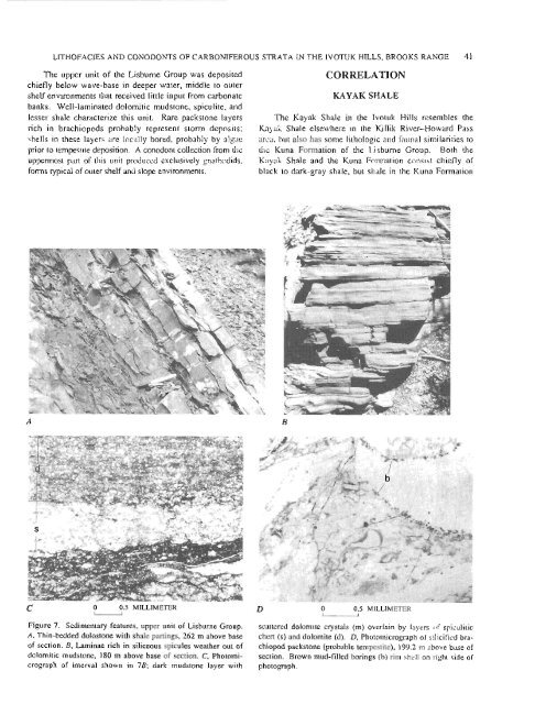
The upper unit of <strong>the</strong> Lisburne Group was deposited<br />
chiefly below wave-base <strong>in</strong> deeper water, middle to outer<br />
shelf environments that received little <strong>in</strong>put from carbonate<br />
banks. Well-lam<strong>in</strong>ated dolomitic mudstone, spiculite, and<br />
lesser shale characterize this unit. Rare packstone layers<br />
rich <strong>in</strong> brachiopods probably represent storm deposits;<br />
shells <strong>in</strong> <strong>the</strong>se layers are locally bored, probably <strong>by</strong> algae<br />
prior to tempestite deposition. A conodont collection from <strong>the</strong><br />
uppermost part of this unit produced exclusively gnathodids,<br />
forms typical of outer shelf and slope environments.<br />
- C 0 0.5 MILLIMETER<br />
0<br />
CORRELATION<br />
KAYAK SHALE<br />
The Kayak Shale <strong>in</strong> <strong>the</strong> Ivotuk Hills resembles <strong>the</strong><br />
Kayak Shale elsewhere <strong>in</strong> <strong>the</strong> Killik River-Howard Pass<br />
area, but also has some lithologic and faunal similarities to<br />
<strong>the</strong> Kuna Formation of <strong>the</strong> Lisburne Group. Both <strong>the</strong><br />
Kayak Shale and <strong>the</strong> Kuna Formation consist chiefly of<br />
black to dark-gray shale, but shale <strong>in</strong> <strong>the</strong> Kuna Formation<br />
0.5 MILLIMETER<br />
u<br />
Figure 7. Sedimentary features, upper unit of Lisburne Group. scattered dolomite crystals (m) overla<strong>in</strong> <strong>by</strong> layers of spiculitic<br />
A, Th<strong>in</strong>-bedded dolostone with shale part<strong>in</strong>gs, 262 m above base chert (s) and dolomite (d). D, Photomicrograph of silicified bra-<br />
of section. B, Lam<strong>in</strong>ae rich <strong>in</strong> siliceous spicules wea<strong>the</strong>r out of chiopod packstone (probable tempestite), 199.2 m above base of<br />
dolomitic mudstone, 180 m above base of section. C, Photomi- section. Brown mud-filled bor<strong>in</strong>gs (b) rim shell on right side of<br />
crograph of <strong>in</strong>terval shown <strong>in</strong> 7B; dark mudstone layer with photograph.<br />
41


