

Geologic Studies in Alaska by the U.S. Geological Survey, 1992
Geologic Studies in Alaska by the U.S. Geological Survey, 1992
Geologic Studies in Alaska by the U.S. Geological Survey, 1992

You also want an ePaper? Increase the reach of your titles
YUMPU automatically turns print PDFs into web optimized ePapers that Google loves.
EARLY CENOZOIC DEPOSITIONAL SYSTEMS, MATANUSKA COAL FIELD 1 03<br />
with<strong>in</strong> <strong>the</strong> Chickaloon Formation, based on radiometric<br />
age dat<strong>in</strong>g, was identified <strong>by</strong> Triplehorn and o<strong>the</strong>rs (1984).<br />
The <strong>in</strong>vestigation of megafloras <strong>by</strong> Wolfe and o<strong>the</strong>rs<br />
(1966) <strong>in</strong>dicates that <strong>the</strong>se Paleocene and Eocene deposits<br />
accumulated <strong>in</strong> a subtropical, wann-temperate climate.<br />
Economic coalbeds are concentrated <strong>in</strong> <strong>the</strong> upper 425<br />
m of <strong>the</strong> Chickaloon Formation. A few th<strong>in</strong>, scattered<br />
coalbeds occur <strong>in</strong> <strong>the</strong> lower part. The upper part of <strong>the</strong><br />
Chickaloon Formation was subdivided <strong>by</strong> Barnes and<br />
Payne (1956) <strong>in</strong>to four major coal-bear<strong>in</strong>g groups gener-<br />
ally separated <strong>by</strong> noncoaly <strong>in</strong>tervals. The upper three of<br />
<strong>the</strong>se coal groups, identified <strong>in</strong> this study as coal zones,<br />
from bottom to top <strong>in</strong>clude <strong>the</strong> Eska, Premier, and<br />
Jonesville coal zones (fig. 4). The Midway coalbed, be-<br />
tween <strong>the</strong> Eska and Premier coal zones, occurs 25 to 23 m<br />
below <strong>the</strong> base of <strong>the</strong> Premier zone. The study <strong>in</strong>terval<br />
<strong>in</strong>cludes <strong>the</strong>se four coal zones of <strong>the</strong> uppermost part of <strong>the</strong><br />
Chickaloon Formation (about 160 m) and <strong>the</strong> overly<strong>in</strong>g<br />
lowermost part of <strong>the</strong> Wishbone Formation (15-23 m).<br />
The coal zones, which range from 18 to 80 m <strong>in</strong> thickness,<br />
are separated <strong>by</strong> coal-free sequences that are as thick as 84<br />
m <strong>in</strong> <strong>the</strong> Wishbone Hill district.<br />
Although <strong>the</strong> Premier and Jonesville coal zones were<br />
strip m<strong>in</strong>ed <strong>in</strong> <strong>the</strong> study area, reserves of about 102 million<br />
metric tons are estimated to rema<strong>in</strong> <strong>in</strong> <strong>the</strong> Wishbone Hill<br />
syncl<strong>in</strong>e (Barnes, 1967, p. 11). These coal zones consist<br />
of s<strong>in</strong>gle and dull- to bright-banded coalbeds <strong>in</strong>terbedded<br />
with carbonaceous shale, bony coal, mudstone, tonste<strong>in</strong><br />
beds, and ironstone concretions. In <strong>the</strong> Evan Jones coal<br />
m<strong>in</strong>e, <strong>the</strong> coal quality on an as-received basis varies between<br />
<strong>the</strong> Premier and Jonesville coal zones (Barnes and<br />
Payne, 1956). The as-received heat-of-combustion of <strong>the</strong><br />
coals range from 10,290 to 11,650 Btu~lb for <strong>the</strong> Jonesville<br />
coal zone and from 10,450 to 11,890 Btullb for <strong>the</strong><br />
Premier coal zone. Apparent rank of coals is high-volatile<br />
B bitum<strong>in</strong>ous. Ash contents range from 14 to 20 percent<br />
for <strong>the</strong> Jonesville coal zone and from 12 to 22 percent for<br />
<strong>the</strong> Premier coal zone. Sulfur contents range from 0.3 to<br />
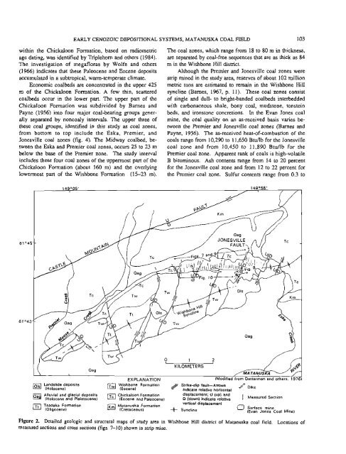
(Ols( Landslide deposits (Twl Wishbone Formation Strike-slip fault-Arrows ++ + Dike<br />
(Holocene) (Eocene) @ <strong>in</strong>dicate relative horizontal<br />
laa$ Alluvial and glacial deposits Chickaloon Formation displacement; U (up) and<br />
(Holocene and Pleistocene) ((Eocene and Paleocene) D (down) <strong>in</strong>dicate relative I Measured Section<br />
ITtJ Tsadaka Formation<br />
(Oligocene)<br />
Matanuska Formation vertical displacement<br />
(Cretaceous) -$i- Syncl<strong>in</strong>e 0 Surface m<strong>in</strong>e<br />
(Evan Jones Coal M<strong>in</strong>e)<br />
Figure 2. Detailed geologic and structural maps of study area <strong>in</strong> Wishbone Hill district of Matanuska coal field. Locations of<br />
measured sections and cross sections (figs. 7-10) shown <strong>in</strong> strip m<strong>in</strong>e.


