

Geologic Studies in Alaska by the U.S. Geological Survey, 1992
Geologic Studies in Alaska by the U.S. Geological Survey, 1992
Geologic Studies in Alaska by the U.S. Geological Survey, 1992

Create successful ePaper yourself
Turn your PDF publications into a flip-book with our unique Google optimized e-Paper software.
EARLY CENOZOIC DEPOSITIONAL SYSTEMS, MATANUSKA COAL FIELD<br />
METERS<br />
O KILOMETERS<br />
109<br />
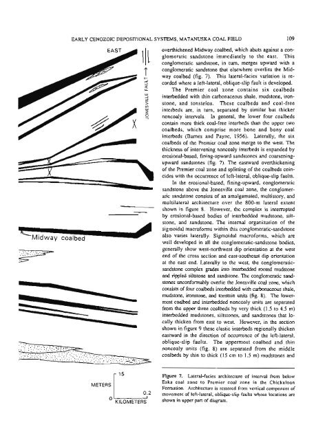
overthickened Midway coalbed, which abuts aga<strong>in</strong>st a con-<br />
glomeratic sandstone immediately to <strong>the</strong> east. This<br />
conglomeratic sandstone, <strong>in</strong> turn, merges upward with a<br />
conglomeratic sandstone that elsewhere overlies <strong>the</strong> Mid-<br />
way coalbed (fig. 7). This lateral-facies variation is re-<br />
corded where a left-lateral, oblique-slip fault is developed.<br />
The Premier coal zone conta<strong>in</strong>s six coalbeds<br />
<strong>in</strong>terbedded with th<strong>in</strong> carbonaceous shale, mudstone, iron-<br />
stone, and tonste<strong>in</strong>s. These coalbeds and coal-free<br />
<strong>in</strong>terbeds are, <strong>in</strong> turn, separated <strong>by</strong> similar but thicker<br />
noncoaly <strong>in</strong>tervals. In general, <strong>the</strong> lower four coalbeds<br />
conta<strong>in</strong> more thick coal-free <strong>in</strong>terbeds than <strong>the</strong> upper two<br />
coalbeds, which comprise more bone and bony coal<br />
<strong>in</strong>terbeds (Barnes and Payne, 1956). Laterally, <strong>the</strong> six<br />
coalbeds of <strong>the</strong> Premier coal zone merge to <strong>the</strong> west. The<br />
thickness of <strong>in</strong>terven<strong>in</strong>g noncoaly <strong>in</strong>terbeds is expanded <strong>by</strong><br />
erosional-based, f<strong>in</strong><strong>in</strong>g-upward sandstones and coarsen<strong>in</strong>g-<br />
upward sandstones (fig. 7). The eastward overthicken<strong>in</strong>g<br />
of <strong>the</strong> Premier coal zone and splitt<strong>in</strong>g of <strong>the</strong> coalbeds co<strong>in</strong>-<br />
cides with <strong>the</strong> occurrence of left-lateral, oblique-slip faults.<br />
In <strong>the</strong> erosional-based, f<strong>in</strong><strong>in</strong>g-upward, conglomeratic<br />
sandstone above <strong>the</strong> Jonesville coal zone, <strong>the</strong> conglomer-<br />
atic sandstone consists of an amalgamated, multistory, and<br />
multilateral architecture over <strong>the</strong> 800-m lateral extent<br />
shown <strong>in</strong> figure 8. However, <strong>the</strong> complex is <strong>in</strong>terrupted<br />
<strong>by</strong> erosional-based bodies of <strong>in</strong>terbedded mudstone, silt-<br />
stone, and sandstone. The <strong>in</strong>ternal organization of <strong>the</strong><br />
sigmoidal macroforms with<strong>in</strong> this conglomeratic-sandstone<br />
also varies laterally. Sigmoidal macroforms, which are<br />
well developed <strong>in</strong> all <strong>the</strong> conglomeratic-sandstone bodies,<br />
generally show west-northwest dip orientation at <strong>the</strong> west<br />
end of <strong>the</strong> cross section and east-sou<strong>the</strong>ast dip orientation<br />
at <strong>the</strong> east end. Laterally to <strong>the</strong> west, <strong>the</strong> conglomeratic-<br />
sandstone complex grades <strong>in</strong>to <strong>in</strong>terbedded rooted mudstone<br />
and rippled siltstone and sandstone. The conglomeratic sand-<br />
stone; kconformably overlie <strong>the</strong> Jonesville coal zone, which<br />
consists of four coalbeds <strong>in</strong>terbedded with carbonaceous shale,<br />
mudstone, ironstone, and tonste<strong>in</strong> units (fig. 8). The lower-<br />
most coalbed and <strong>in</strong>terbedded noncoaly units are separated<br />
from <strong>the</strong> upper three coalbeds <strong>by</strong> very thick (1.5 to 4.5 m)<br />
<strong>in</strong>terbedded mudstones, siltstones, and sandstones that lo-<br />
cally thicken from east to west. However, <strong>in</strong> <strong>the</strong> section<br />
shown <strong>in</strong> figure 9 <strong>the</strong>se clastic <strong>in</strong>terbeds regionally thicken<br />
eastward <strong>in</strong> <strong>the</strong> direction of occurrence of <strong>the</strong> left-lateral,<br />
oblique-slip faults. The uppermost coalbed and th<strong>in</strong><br />
noncoaly units (fig. 8) are separated from <strong>the</strong> middle<br />
coalbeds <strong>by</strong> th<strong>in</strong> to thick (15 cm to 1.5 m) mudstones and<br />
Figure 7. Lateral-facies architecture of <strong>in</strong>terval from below<br />
Eska coal zone to Premier coal zone <strong>in</strong> <strong>the</strong> Chickaloon<br />
Formation. Architecture is restored from vertical component of<br />
movement of left-lateral, oblique-slip faults whose locations are<br />
shown <strong>in</strong> upper part of diagram.


