

Geologic Studies in Alaska by the U.S. Geological Survey, 1992
Geologic Studies in Alaska by the U.S. Geological Survey, 1992
Geologic Studies in Alaska by the U.S. Geological Survey, 1992

Create successful ePaper yourself
Turn your PDF publications into a flip-book with our unique Google optimized e-Paper software.
RESERVOIR FRAMEWORK ARCHITECTURE, CLAMGULCHIAN TYPE SECTION, STERLING FORMATION 121<br />
cally <strong>the</strong>se sequences comprise as much as 75 percent<br />
sandstone, about 24 percent siltstone and mudstone, and 1<br />
percent coal, carbonaceous shale, and tonste<strong>in</strong>s.<br />
SANDSTONE SEQUENCES<br />
Sandstone occurs <strong>in</strong> f<strong>in</strong><strong>in</strong>g-upward sequences rang<strong>in</strong>g<br />
from coarse to f<strong>in</strong>e gra<strong>in</strong>ed, light gray to buff, and locally<br />
<strong>in</strong>clude lag conglomerates of coal spars and pebble- to<br />
boulder-size mudstones. These sandstones are, <strong>in</strong> turn,<br />
amalgamated <strong>in</strong>to multiscoured bodies with <strong>the</strong> <strong>in</strong>ternal<br />
scour bases locally marked <strong>by</strong> lag conglomerates. These<br />
multiscoured sandstones are up to 65 m <strong>in</strong> thickness and<br />
more than 3 km long. The sandstone bodies display<br />
I<br />
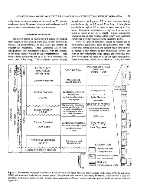
FORMATION<br />
THICKNESS<br />
(IN METERS)<br />
Unnamed deposits<br />
megaforesets as high as 3.5 m and common trough<br />
crossbeds as high as 1.2 m and 23 m long. A few planar<br />
crossbeds as high as 1.5 m occur <strong>in</strong> cross sets up to 3 m<br />
high. Convolute lam<strong>in</strong>ations as high as 3 m occur <strong>in</strong><br />
zones as much as 6.7 m <strong>in</strong> height. Ripple lam<strong>in</strong>ations<br />
(climb<strong>in</strong>g and current ripples) ei<strong>the</strong>r locally cap sandstone<br />
complexes or occur with<strong>in</strong> scoured sandstone bodies.<br />
Very f<strong>in</strong>e gra<strong>in</strong>ed sandstone occurs as tabular bodies<br />
with sharp to gradational bases and gradational tops. They<br />
commonly exhibit climb<strong>in</strong>g and current ripple lam<strong>in</strong>ations.<br />
In places, a few narrow (a few millimeters across) and<br />
short (a few centimeters long) vertical and horizontal bur-<br />
rows have destroyed some or all of <strong>the</strong> ripple lam<strong>in</strong>ations.<br />
These sandstones, which are as thick as 2.5 m, are ei<strong>the</strong>r<br />
DESCRIPTION<br />
Alluvium and<br />
glacial deposits<br />
PROPOSED STAGE<br />
(Wolf and<br />
o<strong>the</strong>rs, 1966)<br />
Sterl<strong>in</strong>g Formation Sandstone, siltstone,<br />
mudstone,<br />
Clamgulchian<br />
--?---?--<br />
0-2.100 carbonaceous shale,<br />
and lignite<br />
Early Pliocene<br />
Homerian<br />
'sandstone, conglom-\-<br />
Upper half of Miocene<br />
-? - - - -?- -<br />
eratic sandstone, silt-<br />
Beluga Formation<br />
stone, mudstone, Late early Miocene<br />
> 1,500 carbonaceous shale, 0' middle Miocene<br />
-, and subbitum<strong>in</strong>ous<br />
coal // Seldovian<br />
Tyonek Formation Sandstone, mudstone, Early Miocene<br />
- ?- - - ?- -<br />
siltstone <strong>in</strong>terbeds, and-<br />
1,200-2,350<br />
subbitum<strong>in</strong>ous Late Oligocene<br />
coal<br />
Hemlock Conglomerate<br />
Sandstone and<br />
90-270 conglomerate<br />
OLDER TERTIARY ROCI


