

Geologic Studies in Alaska by the U.S. Geological Survey, 1992
Geologic Studies in Alaska by the U.S. Geological Survey, 1992
Geologic Studies in Alaska by the U.S. Geological Survey, 1992

Create successful ePaper yourself
Turn your PDF publications into a flip-book with our unique Google optimized e-Paper software.
110<br />
GEOLOGIC STUDIES IN ALASKA BY THE U.S. GEOLOGICAL SURVEY, <strong>1992</strong><br />
siltstones. The middle coalbeds commonly conta<strong>in</strong> bone<br />
<strong>in</strong> contrast to <strong>the</strong> uppermost coalbed, which commonly<br />
conta<strong>in</strong>s bony coal. The conglomeratic sandstones (see<br />
fig. 8) grade upward <strong>in</strong>to a thick (as much as 10 m) mud-<br />
stone with some siltstone <strong>in</strong>terbeds, which <strong>in</strong> turn, is<br />
unconformably overla<strong>in</strong> <strong>by</strong> conglomerates of <strong>the</strong> Wishbone<br />
Formation.<br />
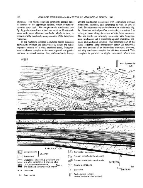
In <strong>the</strong> mudstone-siltstone dom<strong>in</strong>ated facies sequence<br />
between <strong>the</strong> Premier and Jonesville coal zones, <strong>the</strong> facies<br />
sequence consists of a wide, erosional-based, f<strong>in</strong><strong>in</strong>g-up-<br />
ward sandstone complex at <strong>the</strong> west highwall and grades<br />
eastward to coeval narrow, th<strong>in</strong>, multierosional, f<strong>in</strong><strong>in</strong>g-<br />
WEST<br />
upward sandstones associated with coarsen<strong>in</strong>g-upward<br />
mudstones, siltstones, and sandstones as well as th<strong>in</strong> to<br />
thick, discont<strong>in</strong>uous coal and carbonaceous shale beds (fig.<br />
9). Abundant vertical petrified tree trunks, as much as 6 m<br />
<strong>in</strong> height, occur along <strong>the</strong> extent of this facies sequence.<br />
The tree trunks are primarily associated with f<strong>in</strong><strong>in</strong>g-up-<br />
ward sandstones and a coarsen<strong>in</strong>g-upward mudstone, silt-<br />
stone, and sandstone complex. The uppermost part of <strong>the</strong><br />
facies sequence ly<strong>in</strong>g immediately below <strong>the</strong> Jonesville<br />
coal zone consists of an <strong>in</strong>terbedded mudstone, siltstone,<br />
and silty sandstone complex that thickens eastward. This<br />
complex is parallel to ripple lam<strong>in</strong>ated where not<br />
5, Trough crossbeds (large-scale)<br />
1 /<br />
(11 t Jonesvilla<br />
- -<br />
. -.<br />
. .<br />
Mudstone, siltstone, Overbank and<br />
- -. Ed and silty sandstone 1 channel plug<br />
Coal, carbonaceous shale, }Mire<br />
and coal and carbonaceous shale<br />
& Trough crossbeds (small-scale)<br />
"-- - - Ripple lam<strong>in</strong>ations<br />
METERS<br />
8 8 Ironstone B Bentonite O METERS<br />
AA Root marks 111 Fault-Arrows <strong>in</strong>dicate<br />
relative horizontal displacement


