

Geologic Studies in Alaska by the U.S. Geological Survey, 1992
Geologic Studies in Alaska by the U.S. Geological Survey, 1992
Geologic Studies in Alaska by the U.S. Geological Survey, 1992

You also want an ePaper? Increase the reach of your titles
YUMPU automatically turns print PDFs into web optimized ePapers that Google loves.
DEPOSITIONAL SEQUENCES IN ATIGUN SYNCLINE AND SLOPE MOUNTAIN AREA<br />
predom<strong>in</strong>ated dur<strong>in</strong>g thi overall transgression. Several<br />
sandstone units were deposited on <strong>the</strong> LCU, <strong>in</strong>clud<strong>in</strong>g <strong>the</strong><br />
Put River sand, <strong>the</strong> Thomson sand, and <strong>the</strong> Walakpa sand-<br />
stone (all of local usage), as well as <strong>the</strong> Kemik Sandstone<br />
(Melv<strong>in</strong>, 1986; Mull, 1987) and <strong>the</strong> upper part of <strong>the</strong><br />
Kuparuk Formation (fig. 4). Additional unnamed sand-<br />
stones at this stratigraphic position are penetrated <strong>by</strong> nu-<br />
merous wells, but <strong>the</strong>ir areal extent is unknown (Bird,<br />
1986, fig. 7).<br />
The Put River sand (Jamison and o<strong>the</strong>rs, 1980; Bird,<br />
1988), located just west of Prudhoe Bay (fig. 4), has an<br />
areal extent of about 25 square kilometers, a maximum<br />
thickness of about 21 m, and an elongated north-south<br />
s<strong>in</strong>uous outl<strong>in</strong>e consistent with ei<strong>the</strong>r a channel or bar de-<br />
posit (see isopach map <strong>in</strong> McIntosh, 1977, or <strong>the</strong> outl<strong>in</strong>e<br />
map <strong>in</strong> Bird, 1986, fig. 8). The Thomson sand (Gautier,<br />
1987; Bird and o<strong>the</strong>rs, 1987; Bird, 1988) consists of as<br />
much as 90 m of sandstone composed of more than 50<br />
percent detrital dolomite gra<strong>in</strong>s, and locally <strong>in</strong>cludes<br />
pebble, cobble, and boulder conglomerate with boulders as<br />
large as 1.4 m (Gautier, 1987). These deposits are cer-<br />
ta<strong>in</strong>ly of local derivation and may represent a nonmar<strong>in</strong>e<br />
channel sandstone deposited <strong>in</strong> an <strong>in</strong>cised valley as part of<br />
sequence<br />
<strong>the</strong> lowstand wedge. Just south of Barrow (fig. I), <strong>the</strong><br />
Walakpa sandstone (Sch<strong>in</strong>dler, 1988) is poorly known, al-<br />
though recent drill<strong>in</strong>g <strong>in</strong> <strong>the</strong> area suggests that <strong>the</strong><br />
Walakpa sandstone is more sheetlike than <strong>the</strong> Put River<br />
sand (R. Glenn, personal communication, <strong>1992</strong>). The<br />
Kemik Sandstone (Mull, 1987) is one of <strong>the</strong> thickest and<br />
most widespread of <strong>the</strong>se sandstones (Bird and o<strong>the</strong>rs,<br />
1987, fig. 7.11). The upper member of <strong>the</strong> Kuparuk For-<br />
mation (Carman and Hardwick, 1983) (equivalent to <strong>the</strong><br />
Kuparuk River Formation of Masterson and Paris, 1987)<br />
overlies <strong>the</strong> LCU and was deposited <strong>in</strong> a mar<strong>in</strong>e shelf set-<br />
t<strong>in</strong>g dur<strong>in</strong>g a period of extensional fault<strong>in</strong>g. This part of<br />
<strong>the</strong> Kuparuk displays considerable stratigraphic complexity<br />
<strong>in</strong>clud<strong>in</strong>g two transgressive episodes and two regressive<br />
episodes plus <strong>the</strong> cutt<strong>in</strong>g of an <strong>in</strong>tra-unit unconformity.<br />
The <strong>in</strong>terplay of eustatic sea-level change and tectonism<br />
has yet to be resolved for <strong>the</strong>se rocks.<br />
The lowstand systems tract depositional model pre-<br />
dicts <strong>the</strong> occurrence of sets of sandstone-filled channels at<br />
<strong>the</strong> LCU. Their thickness and preservation depends on a<br />
number of factors, <strong>in</strong>clud<strong>in</strong>g competency of <strong>the</strong> fluvial<br />
system, a source of sediment, and preservation of <strong>the</strong> val-<br />
ley fill dur<strong>in</strong>g transgression with limited rework<strong>in</strong>g and<br />
NE<br />
A'<br />
Gilead Creek area<br />
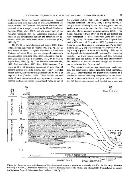
Figure 3. Summary schematic diagram of five depositional sequence boundaries tentatively identified <strong>in</strong> this study. Sequence<br />
boundary 6 is early(?) Cenomanian depositional sequence boundary described <strong>by</strong> Phillips and o<strong>the</strong>rs (1990). Nomenclature for units <strong>in</strong><br />
<strong>the</strong> Nanushuk Group slightly revised from Huffman (1989, fig. 227).<br />
51


