

Geologic Studies in Alaska by the U.S. Geological Survey, 1992
Geologic Studies in Alaska by the U.S. Geological Survey, 1992
Geologic Studies in Alaska by the U.S. Geological Survey, 1992

You also want an ePaper? Increase the reach of your titles
YUMPU automatically turns print PDFs into web optimized ePapers that Google loves.
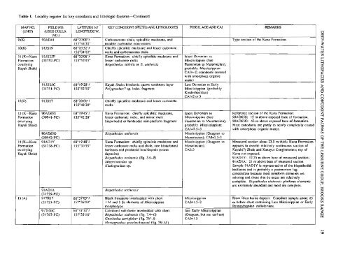
Table 1. Locality register for key conodonts and lithologic features-Cont<strong>in</strong>ued<br />
MAP NO.<br />
(m<br />
9 (K)<br />
10(K)<br />
1 I (K-Kuna<br />
Formation<br />
overly<strong>in</strong>g<br />
Kayak Shale)<br />
12(K)<br />
13 (K-Kuna<br />
Formation<br />
overly<strong>in</strong>g<br />
Kayak Shale)<br />
14 (K-Kuna<br />
Formation<br />
overly<strong>in</strong>g<br />
Kayak Shale)<br />
15 (A)<br />
FIELD NO.<br />
(USGS COLLN.<br />
NO.)<br />
90AD41<br />
91JS19<br />
9 1 JS25F<br />
(3 1752-PC)<br />
91JS25C<br />
(31751-PC)<br />
91JS27<br />
90AD65S<br />
(30941-PC)<br />
90AD650<br />
(30942-PC)<br />
91 ADIY<br />
(3 1738-PC)<br />
91ADIA<br />
(3 1739-PC)<br />
91TR17<br />
(3 172 1 -PC)<br />
91Tr30C<br />
(3 1767-PC)<br />
LATlTLTDE NJ<br />
LONGITUDE W.<br />
68"20'00"/<br />
1 57"44'3OU<br />
68"20'52"/<br />
156"04'20"<br />
68"20'08"1<br />
155"52'4SU<br />
68" 19'28"l<br />
155O52'55"<br />
68"20'00"/<br />
155"48'20"<br />
68" 19'4S"/<br />
155"42'20"<br />
68"19'48"/<br />
15S030'55"<br />
68"37'05"/<br />
157"36'00"<br />
68"37'30"1<br />
157"33'10"<br />
KEY CONODONT SPECTES AND LITHOLOGTES<br />
Carbonaceous shale, spiculitic mudstone, and<br />
notable carbonate concretions.<br />
Chiefly spiculitic mudstone and lesser carbonate<br />
rocks and carbonaceous shale<br />
Kuna Formation: chiefly spiculitic mudstone and<br />
lesser carbonate rocks<br />
Bispathodus srabilis or B. utahensis<br />
Kayak Shale: bioclastic quartz sandstone layer<br />
Polygnarhus? sp. <strong>in</strong>det. fragment<br />
Chiefly spiculitic mudstone and lesser carbonate<br />
rocks<br />
Kuna Formation: chiefly spiculitic mudstone,<br />
lesser carbonate rocks, and m<strong>in</strong>or shale<br />
bispathodid or h<strong>in</strong>deodid mid-platform fragment<br />
Bispathodus urahensis<br />
Kuna Formation: chiefly spiculitic mudstone and<br />
lesser carbonate rocks and shale; rare bioturbated<br />
horizons and productid brachiopods (storm<br />
deposits)<br />
Bispathodus utahensis (fig. 5A-0<br />
Idioprioniodus sp.<br />
Kladognarhus sp.<br />
Bispathodus utahensis<br />
Black limestone <strong>in</strong>terbedded with chert<br />
1 M and 1 Sc elements of Mississippian<br />
morphotype<br />
Calcitized radiolarite <strong>in</strong>terbedded with chert<br />
Bispathodus urahensis (fig. 7A-0<br />
Gnathodus semiglaber (fig. 7H-J)<br />
Mestognathus pmebeckmanni (fig. 7K-M)<br />
FOSSIL AGE AND CAI<br />
latest Devonian to<br />
Mississippian (late<br />
Famennian to Meramecian),<br />
probably Mississippian<br />
CAI=-2; conodonts covered<br />
with amorphous organic<br />
matter<br />
Late Devonian to Early<br />
Mississippian (probably<br />
K<strong>in</strong>derhookian)<br />
CAI=2 or 3<br />
latest Devonian to<br />
Mississippian (late<br />
Famennian to Meramecian),<br />
probably Mississippian;<br />
CAI=2.5-3<br />
Mississippian (Osagean to<br />
Meramecian); CAI=2.5-3<br />
Mississippian (Osagean to<br />
Meramecian);<br />
CAI=3<br />
Mississippian<br />
CAIz1.5-2<br />
late Early Mississippian<br />
(Osagean, but not earliest)<br />
CAI=1.5<br />
REMARKS<br />
Type section of <strong>the</strong> Kuna Formation<br />
Reference section of <strong>the</strong> Kuna Formation:<br />
90AD65S: 15 m above exposed base of formation.<br />
90AD650: 45 m above exposed base of formation.<br />
Most conodonts are partly to nearly completely coated<br />
with amorphous organic matter.<br />
Measured section about 23.5 m thick; Kuna Formation<br />
appears to overlie relatively cont<strong>in</strong>uous section of<br />
Kayak(?) Shale and Kanayut Conglomerate; top of<br />
Kuna not exposed.<br />
91 AD1 Y: 12.25 m above base of measured section;<br />
9 1 AD I A; 2 1 m above base of measured section.<br />
Sample 91ADIY is representative of <strong>the</strong> bispathodid<br />
biofacies and is probably a postmortem lag<br />
concentrate because most ramiform elements are<br />
miss<strong>in</strong>g and those that do occur are relatively<br />
complete. Bispathodus utahensis platform elements<br />
are extremely abundant and most are complete.<br />
From Bion barite deposit. Conodont sample about 25<br />
m below chert conta<strong>in</strong><strong>in</strong>g Late Mississippian or Early<br />
Pennsylvanian radiolarians.


