

Geologic Studies in Alaska by the U.S. Geological Survey, 1992
Geologic Studies in Alaska by the U.S. Geological Survey, 1992
Geologic Studies in Alaska by the U.S. Geological Survey, 1992

Create successful ePaper yourself
Turn your PDF publications into a flip-book with our unique Google optimized e-Paper software.
114 GEOLOGIC STUDIES IN ALASKA BY THE U.S. GEOLOGICAL SURVEY. <strong>1992</strong><br />
range from 1:4 to 1:30, are with<strong>in</strong> <strong>the</strong> range for anasto-<br />
mosed streams suggested <strong>by</strong> Smith (1983). The common<br />
occurrence of mud drapes between steeply dipp<strong>in</strong>g silty<br />
sandstone foresets and <strong>the</strong> vertical stack<strong>in</strong>g of <strong>the</strong>se chan-<br />
nel-fill units with low thickness-to-width ratios (1:4 to 1:6)<br />
are also characteristic of anastomosed streams (Galloway<br />
and Hobday, 1983). Widespread bioturbated mudstone,<br />
siltstone, and silty sandstone deposited <strong>in</strong> lacustr<strong>in</strong>e set-<br />
t<strong>in</strong>gs suggest a close association of <strong>the</strong> anastornosed chan-<br />
nels with flood-bas<strong>in</strong> lakes.<br />
Coal zones immediately below and above deposits of<br />
<strong>the</strong>se fluvial systems represent organic accumulation <strong>in</strong><br />
mires which developed on abandoned meander (Premier<br />
coal zone) and anastomosed (Jonesville coal zone) belts.<br />
The high ash content (as much as 25 percent) and abun-<br />
dant carbonaceous shale and mudstone <strong>in</strong>terbeds associated<br />
with <strong>the</strong> coalbeds <strong>in</strong>dicate that <strong>the</strong>se mires were low ly<strong>in</strong>g<br />
or topogenous. Although mires formed on topographically<br />
high meander belts such as that below <strong>the</strong> Premier coal<br />
zone, base level must have been lowered periodically to<br />
permit drown<strong>in</strong>g <strong>by</strong> detrital <strong>in</strong>fluxes. However, detrital <strong>in</strong>-<br />
WEST<br />
- L<br />
fluxes were probably short lived, allow<strong>in</strong>g for <strong>the</strong> reestab-<br />
lishment of <strong>the</strong> mires, until a f<strong>in</strong>al susta<strong>in</strong>ed <strong>in</strong>flux termi-<br />
nated peat accumulation. S<strong>in</strong>ce <strong>the</strong> meander-belt deposits<br />
represent deposition <strong>in</strong> relatively stable, laterally aggrad<strong>in</strong>g<br />
channels probably controlled <strong>by</strong> stable tectonic condition,<br />
we suggest that <strong>the</strong> lower<strong>in</strong>g of base level was caused <strong>by</strong><br />
local subsidence due to sediment compaction. Fur<strong>the</strong>r-<br />
more, splitt<strong>in</strong>g of <strong>the</strong> Premier coal zone <strong>by</strong> meander-belt-<br />
overbank deposits and <strong>the</strong> correspond<strong>in</strong>g th<strong>in</strong>n<strong>in</strong>g of <strong>the</strong><br />
underly<strong>in</strong>g meander-belt deposits <strong>in</strong>dicates that shifts or<br />
avulsion of stream courses promoted differential compac-<br />
tion of laterally offset channel sandstones and f<strong>in</strong>e-gra<strong>in</strong>ed<br />
flood-pla<strong>in</strong> sediments. In addition, channel avulsion and<br />
diversion of crevasse splays may have been enhanced <strong>by</strong><br />
vertical components of movement along contemporaneous<br />
left-lateral, oblique-slip faults. In contrast, <strong>the</strong> lower<strong>in</strong>g of<br />
base level <strong>in</strong> association with <strong>the</strong> mires <strong>in</strong> which <strong>the</strong><br />
Jonesville coal zone accumulated may have been con-<br />
trolled <strong>by</strong> regional tectonic subsidence. Regional lower<strong>in</strong>g<br />
of base level probably started dur<strong>in</strong>g sedimentation of <strong>the</strong><br />
anastornosed streams, whose vertical aggradation is related<br />
.- +<br />
z<br />
t L<br />
o<br />
LL<br />
-<br />
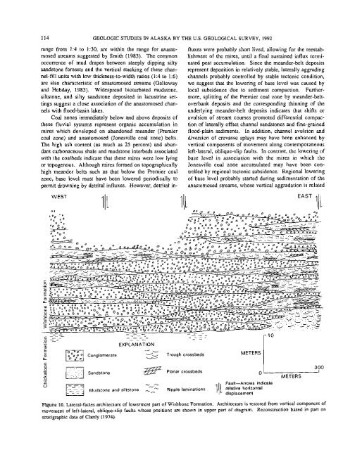
EXPLANATION<br />
-<br />
Conglomerate -'- Trough crossbeds<br />
I<br />
METERS I<br />
Sandstone<br />
Planar crossbeds<br />
0<br />
. -<br />
Ei Mudslone and siltstone -- -- Ripple lam<strong>in</strong>ations relative horizontal<br />
L<br />
- A<br />
0<br />
Fault-Arrows <strong>in</strong>dicate<br />
displacement<br />
METERS<br />
Figure 10. Lateral-facies architecture of lowermost part of Wishbone Formation. Architecture is restored from vertical component of<br />
movement of left-lateral, oblique-slip faults whose positions are shown <strong>in</strong> upper part of diagram. Reconstruction based <strong>in</strong> part on<br />
stratigraphic data of Clardy (1974).<br />
300


