

Geologic Studies in Alaska by the U.S. Geological Survey, 1992
Geologic Studies in Alaska by the U.S. Geological Survey, 1992
Geologic Studies in Alaska by the U.S. Geological Survey, 1992

Create successful ePaper yourself
Turn your PDF publications into a flip-book with our unique Google optimized e-Paper software.
DEPOSITIONAL SEQUENCES IN ATIGUN SYNCLINE AND SLOPE MOUNTAIN AREA<br />
SEQUENCE BOUNDARY 2<br />
The exposure of <strong>the</strong> Fortress Mounta<strong>in</strong> Formation<br />
along <strong>the</strong> north wall of Atigun Gorge is one of <strong>the</strong> few<br />
places where <strong>the</strong> lower contact of <strong>the</strong> Fortress Mounta<strong>in</strong><br />
may be exam<strong>in</strong>ed. At this locality <strong>the</strong> Fortress Mounta<strong>in</strong><br />
Formation overlies at least 600 m of gray concretion-bear-<br />
<strong>in</strong>g mudstone and th<strong>in</strong>-bedded sandstone that has been<br />
mapped as <strong>the</strong> Neocomian Okpikruak Formation <strong>by</strong><br />
BrosgC and o<strong>the</strong>rs (1979) or <strong>the</strong> Albian Torok Formation<br />
<strong>by</strong> Mull and Harris (1989, fig. 99). No direct paleontologic<br />
determ<strong>in</strong>ations of <strong>the</strong> age of <strong>the</strong>se strata at Atigun Gorge<br />
are known. Whereas <strong>the</strong> base of <strong>the</strong> Fortress Mounta<strong>in</strong><br />
Formation is clearly unconformable <strong>in</strong> areas to <strong>the</strong> west,<br />
such as at Ekakavik Mounta<strong>in</strong> and Castle Mounta<strong>in</strong> (Mull,<br />
1985), <strong>the</strong> lower contact of <strong>the</strong> Fortress Mounta<strong>in</strong> Forma-<br />
tion was not mapped as unconformable <strong>in</strong> <strong>the</strong> Atigun<br />
Gorge area (Brosgt and o<strong>the</strong>rs, 1979). The implication is<br />
that sedimentation may have been cont<strong>in</strong>uous throughout<br />
Early Cretaceous time <strong>in</strong> this area. However, <strong>the</strong> lower<br />
contact of <strong>the</strong> Fortress Mounta<strong>in</strong> Formation <strong>in</strong> <strong>the</strong> Atigun<br />
area was reported to be unconformable <strong>by</strong> Crowder (1989,<br />
p. 296). Our prelim<strong>in</strong>ary work suggests that sandstone and<br />
mudstone of <strong>the</strong> basal part of <strong>the</strong> Fortress Mounta<strong>in</strong> For-<br />
mation appear to fill what may be a valley <strong>in</strong>cised <strong>in</strong>to <strong>the</strong><br />
underly<strong>in</strong>g mudstone of <strong>the</strong> Torok or Okpikruak Forma-<br />
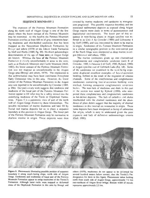
tions. Figure 5 is a panoramic view of part of <strong>the</strong> north<br />
wall of Atigun Gorge illustrat<strong>in</strong>g <strong>the</strong>se relationships. The<br />
possible <strong>in</strong>cisement of mar<strong>in</strong>e mudstone and later fill <strong>by</strong><br />
fluvial and mar<strong>in</strong>e deposits led us to place a sequence<br />
boundary at this position <strong>in</strong> Atigun Gorge. The lower part<br />
of <strong>the</strong> Fortress Mounta<strong>in</strong> Formation may be nonmar<strong>in</strong>e to<br />
shallow mar<strong>in</strong>e <strong>in</strong> orig<strong>in</strong>. These deposits were <strong>the</strong>n<br />
covered <strong>by</strong> mar<strong>in</strong>e mudstone and sandstone as transgres-<br />
sion progressed. This possible sequence boundary and <strong>the</strong><br />
associated sedimentary deposits as exposed along Atigun<br />
Gorge require more study <strong>in</strong> terms of parasequences and<br />
depositional environments. The lower part of this se-<br />
quence <strong>in</strong> west-fac<strong>in</strong>g slopes at Atigun syncl<strong>in</strong>e was re-<br />
ferred to as Unit A <strong>by</strong> Crowder (1989) and Lithosome 4<br />
<strong>by</strong> Goff (1990), and was <strong>in</strong>terpreted <strong>by</strong> <strong>the</strong>m to be mar<strong>in</strong>e<br />
<strong>in</strong> orig<strong>in</strong>. Sandstones of <strong>the</strong> Fortress Mounta<strong>in</strong> Formation<br />
<strong>in</strong> a similar stratigraphic position <strong>in</strong> <strong>the</strong> west-central part<br />
of <strong>the</strong> North Slope were <strong>in</strong>terpreted as deep mar<strong>in</strong>e <strong>in</strong> ori-<br />
g<strong>in</strong> (Molenaar and o<strong>the</strong>rs, 1988).<br />
The mar<strong>in</strong>e sandstones grade up <strong>in</strong>to channelized<br />
conglomerate and conglomeratic sandstone (unit B of<br />
Crowder, 1989; Lithosome 6 of Goff, 1990; Ryherd, 1990)<br />
at Atigun syncl<strong>in</strong>e east of Galbraith Lake (fig. 1B). Some<br />
of <strong>the</strong> sandstones we exam<strong>in</strong>ed <strong>in</strong> <strong>the</strong> west-fac<strong>in</strong>g expo-<br />
sures displayed excellent examples of lateral-accretion<br />
bedd<strong>in</strong>g, formed as <strong>the</strong> result of <strong>the</strong> migration of s<strong>in</strong>uous<br />
channels. Some of <strong>the</strong> conglomerate and conglomeratic<br />
sandstones conta<strong>in</strong><strong>in</strong>g lateral-accretion bedd<strong>in</strong>g were<br />
stacked, form<strong>in</strong>g composite conglomeratic sandstone<br />
bodies. The near-lack of mudstone and shale <strong>in</strong> this part<br />
of <strong>the</strong> section was noted <strong>by</strong> Ryherd (1990), who <strong>in</strong>ter-<br />
preted <strong>the</strong>se conglomerates and conglomeratic sandstones<br />
as fan-deltaic deposits. The lack of turbidites and shales<br />
<strong>in</strong>terbedded with <strong>the</strong> channel sandstones and <strong>the</strong> abun-<br />
dance of plant debris suggest that <strong>the</strong> majority of channel<br />
sandstones <strong>in</strong> this <strong>in</strong>terval are nonmar<strong>in</strong>e <strong>in</strong> orig<strong>in</strong>. These<br />
same deposits have been <strong>in</strong>terpreted as be<strong>in</strong>g of submar<strong>in</strong>e<br />
fan orig<strong>in</strong>, which is easy to understand given <strong>the</strong> poor<br />
exposure and lack of def<strong>in</strong>itive sedimentologic criteria<br />
(Goff, 1 990).<br />
Figure 5. Photomosaic illustrat<strong>in</strong>g possible position of sequence o<strong>the</strong>rs (1 979), mudstones do not appear to be deformed for<br />
boundary 2 along south-fac<strong>in</strong>g slope, north side of Atigun several hundred meters below contact, thus <strong>the</strong> Torok(?) Fm.<br />
Gorge. Sandstones and mudstones of basal part of <strong>the</strong> Fortress designation for <strong>the</strong>m <strong>in</strong> this figure. Photomosaic taken look<strong>in</strong>g<br />
Mounta<strong>in</strong> Formation appear to onlap mudstones of <strong>the</strong> Torok(?) north from south side of Atigun Gorge, approximately 7.5 km<br />
Formation. Although latter rocks were mapped as deformed east-nor<strong>the</strong>ast of Atigun River bridge. Bottom width of mosaic<br />
strata of <strong>the</strong> Okpikruak Formation <strong>in</strong> this area <strong>by</strong> Brosgt and represents approximately 2.5 km.<br />
53


