Gazetteer of New Zealand Names - 3 November 2011
Gazetteer of New Zealand Names - 3 November 2011
Gazetteer of New Zealand Names - 3 November 2011
Create successful ePaper yourself
Turn your PDF publications into a flip-book with our unique Google optimized e-Paper software.
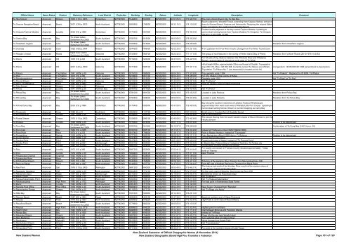
Official Name Name Status Feature Statutory Reference Land District Projection Northing Easting Datum Latitude Longitude Description Comment<br />
Te Oka Stream Approved Stream 1976 (110) p.2453 Canterbury NZTM2000 5144600 1581800 NZGD2000 43 51 05 S 172 46 25 E The main stream flowing into Te Oka Bay<br />
Beach adjacent to Woodhill Forest, extending from Kaipara Harbour entrance<br />
Te Oneone Rangatira Beach Approved Beach 2007 (138) p.3623 North Auckland NZTM2000 5953900 1709000 NZGD2000 36 33 15 S 174 13 05 E down to Muriwai Beach. Kaipara and Helensville. Restoring the original Māori<br />
name and altering the spelling from Rangitira Beach<br />
Coastal locality adjacent to the bay named Taylors Mistake. Updating to<br />
Te Onepoto/Taylors Mistake Approved Locality 2003 (73) p.1896 Canterbury NZTM2000 5174300 1581900 NZGD2000 43 35 03 S 172 46 33 E current dual naming format from Taylors Mistake (Te Onepoto). Te Onepoto<br />
<strong>of</strong>ficial by 31/03/1949 22:858<br />
Te Oneroa Bay Approved Bay<br />
Te Arawa Lakes<br />
Settlement Act 2006<br />
South Auckland NZTM2000 5780700 1915000 NZGD2000 38 03 60 S 176 35 26 E<br />
Te Onewhero Lagoon Approved Lake<br />
Te Arawa Lakes<br />
Settlement Act 2006<br />
South Auckland NZTM2000 5783600 1915900 NZGD2000 38 02 25 S 176 35 58 E Alteration from Onewhero Lagoon<br />
Te Orumata Approved Cave 1992 (169) p.3464 Nelson NZTM2000 5344300 1469400 NZGD2000 42 02 33 S 171 25 19 E 4 km upstream from Fox River mouth. Change from Fox River Tourist Cave<br />
Te Paepae o Aotea Approved Rocks<br />
Ngāti Awa Claims<br />
Settlement Act 2005<br />
Gisborne NZTM2000 5743900 1965700 NZGD2000 38 22 42 S 177 11 10 E The group <strong>of</strong> rock features in the vicinity <strong>of</strong> White Island, Bay <strong>of</strong> Plenty Alteration from Volkner Rocks (28/10/1976 10:2453)<br />
Te Pakira Approved Hill 1978 (13) p.422 South Auckland NZTM2000 5719000 1926400 NZGD2000 38 37 03 S 176 44 55 E<br />
For hill (site <strong>of</strong> trig. Station) between the Whirinaki River and Whataroa<br />
Stream, approximately 6 kilometres south-west <strong>of</strong> Te Whati<br />
Te Pakira Approved Hill 2001 (142) p.3600 Gisborne NZTM2000 5777300 1995100 NZGD2000 38 03 57 S 177 30 11 E<br />
Hill at height 826m, approximately 20km south-east <strong>of</strong> Opotiki. Topographic<br />
map 260 X16, Motu, GR 052 388. Currently named Te Pakora (not <strong>of</strong>ficial).<br />
Trig station “Te Pakora No 1” (not beaconed) is located on this hill.<br />
Corrigendum: 14/05/2009 66:1498 (amendment to description)<br />
Te Pakora Approved Trig Station 1941 (HON) p.35 Gisborne NZTM2000 5776100 1995500 NZGD2000 38 04 35 S 177 30 30 E Trig, geodetic code: 1294 Not "Te Pakera". Replaced by ID 6558, Te Whatui<br />
Te Pare Approved Trig Station 1973 (15) p.365 South Auckland NZTM2000 5918600 1851100 NZGD2000 36 50 43 S 175 48 58 E For Trig. Station in the vicinity <strong>of</strong> Hahei<br />
Te Pareoterawahirua Approved Trig Station 1941 (HON) p.35 South Auckland NZTM2000 5805300 1912900 NZGD2000 37 50 46 S 176 33 21 E Geodetic code 1302 Not "Te Pare" or "Te Pari"<br />
Te Parera Stream Approved Stream 1941 (HON) p.35 Gisborne NZTM2000 5813200 2083800 NZGD2000 37 42 03 S 178 29 10 E Not "Te Parira"<br />
Te Pari o Te Mataahua Approved Point 1987 (62) p.1964 Otago NZTM2000 4926400 1424400 NZGD2000 45 47 37 S 170 44 26 E Point on eastern coast <strong>of</strong> Otago Peninsula<br />
Te Pato Stream Approved Stream 1941 (HON) p.35 Gisborne NZTM2000 5742800 1980700 NZGD2000 38 22 55 S 177 21 28 E<br />
Te Pohue Approved Locality 1941 (HON) p.35 Hawke's Bay NZTM2000 5648700 1917500 NZGD2000 39 15 11 S 176 40 45 E Not "Te Pohui"<br />
Te Pōhue Bay Approved Bay<br />
Te Arawa Lakes<br />
Settlement Act 2006<br />
South Auckland NZTM2000 5781000 1891500 NZGD2000 38 04 19 S 176 19 23 E Located in Lake Rotorua Alteration from Pohue Bay<br />
Te Pōhue Bay Approved Bay<br />
Te Arawa Lakes<br />
Settlement Act 2006<br />
South Auckland NZTM2000 5784500 1908400 NZGD2000 38 02 05 S 176 30 48 E Located in Lake Rotoehu Alteration from Te Pohue Bay<br />
Te Pohue/Camp Bay Approved Bay 2003 (73) p.1896 Canterbury NZTM2000 5170400 1582400 NZGD2000 43 37 09 S 172 46 55 E<br />
Bay along the southern shoreline <strong>of</strong> Lyttelton Harbour/Whakaraupō,<br />
approximately 3km west south-west <strong>of</strong> Waitata/Little Port Cooper. Updating to<br />
current dual naming format. Shown on current mapping as Camp Bay<br />
Te Poupouotu Approved Cove 1988 (2) p.31 Southland NZTM2000 4952600 1131700 NZGD2000 45 25 23 S 167 00 50 E Small cove in Crooked Arm <strong>of</strong> Doubtful Sound<br />
Te Pouwhakatutu Approved Locality 1941 (HON) p.35 South Auckland NZTM2000 5728000 1865300 NZGD2000 38 33 25 S 176 02 40 E Not "Te Pouhakatutu"<br />
Te Puaha Stream Approved Stream 1976 (110) p.2453 Canterbury NZTM2000 5155600 1586100 NZGD2000 43 45 09 S 172 49 38 E<br />
The stream flowing from the south-western slopes <strong>of</strong> Mount Sinclair to join the<br />
Hikuika Stream<br />
Te Puapua Approved Locality 1928 (HON) p.35 South Auckland NZTM2000 5776300 1874000 NZGD2000 38 07 11 S 176 07 32 E Position to be determined<br />
Te Puna Bay Approved Bay<br />
Te Arawa Lakes<br />
Settlement Act 2006<br />
South Auckland NZTM2000 5763700 1901900 NZGD2000 38 13 27 S 176 26 55 E Confirmation <strong>of</strong> Te Puna Bay (1941 Hon p. 35)<br />
Te Puna Inlet Approved Bay 1964 (79) p.2365 North Auckland NZTM2000 6106100 1695100 NZGD2000 35 11 01 S 174 02 40 E Instead <strong>of</strong> Ti Mangonui Inlet (29/07/1948 42:939)<br />
Te Puna Point Approved Point 1974 (11) p.233 South Auckland NZTM2000 5817800 1769600 NZGD2000 37 46 17 S 174 55 32 E Point in Raglan Harbour. Instead <strong>of</strong> "Tarangaiwi"<br />
Te Punaatuhoe Approved Spring 1928 (HON) p.35 South Auckland NZTM2000 5777300 1882300 NZGD2000 38 06 29 S 176 13 11 E Fairy Spring also <strong>of</strong>ficial (1928 Hon p. 7), Rotorua Position to be determined<br />
Te Puoho Glacier Approved Glacier 1939 (HON) p.35 Southland NZTM2000 5041800 1207400 NZGD2000 44 40 11 S 168 02 50 E Central Darran Mountains<br />
Te Pupuha Point Approved Point 1973 (15) p.365 South Auckland NZTM2000 5917800 1851700 NZGD2000 36 51 08 S 175 49 23 E Coastal point east <strong>of</strong> Hahei. Instead <strong>of</strong> "Te Pupuka Point"<br />
Te Puraka Point Approved Point 1962 (73) p.2021 Marlborough NZTM2000 5454100 1684800 NZGD2000 41 03 36 S 174 00 33 E In Beatrix Bay, Pelorus Sound. Instead <strong>of</strong> Tawhinu, Te Puiaka, etc<br />
Te Puru Approved Locality 1982 (76) p.2163 South Auckland NZTM2000 5897000 1824000 NZGD2000 37 02 47 S 175 31 08 E Confirmation <strong>of</strong> name <strong>of</strong> town and stream<br />
Te Puru Approved Locality 1973 (15) p.365 South Auckland NZTM2000 5897200 1823900 NZGD2000 37 02 41 S 175 31 04 E<br />
For locality and stream in Thames County situated approximately 7 miles<br />
north <strong>of</strong> Thames<br />
Te Puru Approved Locality 1939 (HON) p.35 South Auckland NZTM2000 5896900 1824100 NZGD2000 37 02 51 S 175 31 12 E Near Thames<br />
Te Putaaraukai Channel Approved Channel 1943 (HON) p.35 North Auckland NZTM2000 6129300 1628800 NZGD2000 34 58 42 S 173 18 56 E<br />
Te Putaaraukai River Approved River 1943 (HON) p.35 North Auckland NZTM2000 6126300 1629200 NZGD2000 35 00 20 S 173 19 12 E<br />
Te Putahaehae Stream Approved Stream 1973 (15) p.365 South Auckland NZTM2000 5740300 1755900 NZGD2000 38 28 19 S 174 47 14 E Tributary <strong>of</strong> the Awakino River draining from Maungatewharau (hill)<br />
Te Rae o te Rakau Approved Point 1995 (69) p.1847 North Auckland NZTM2000 6149300 1637700 NZGD2000 34 47 52 S 173 24 44 E Point NE side <strong>of</strong> Karikari Peninsula. Change from Black Point<br />
Te Rae Point Approved Spit 1976 (110) p.2453 Wellington NZTM2000 5691200 1840600 NZGD2000 38 53 43 S 175 46 27 E<br />
The feature just south <strong>of</strong> the Kuratau River mouth at the western shore <strong>of</strong><br />
Lake Taupo. Instead <strong>of</strong> "Kuratau Spit"<br />
Te Raeokahu Headland Approved Cliff 1932 (HON) p.35 North Auckland NZTM2000 5924800 1774100 NZGD2000 36 48 24 S 174 57 06 E On the north coast <strong>of</strong> Motuihe. Also known as Guys Cliff<br />
Te Rakaomaru Spur Approved Ridge 1987 (62) p.1964 Marlborough NZTM2000 5315200 1650300 NZGD2000 42 18 50 S 173 36 37 E Sometimes known as Razorback Spur<br />
Te Rakau Creek Approved Stream 1941 (HON) p.35 South Auckland NZTM2000 5741500 1848800 NZGD2000 38 26 24 S 175 51 02 E Not "Te Rokau"<br />
Te Rakauwhakamataku Point Approved Point 1941 (HON) p.35 Wellington NZTM2000 5393500 1796700 NZGD2000 41 35 10 S 175 21 35 E Not "Te Rakauwhakamatuku"<br />
Te Raketuangiangi Approved High Point 1980 (66) p.1752 Wellington NZTM2000 5663900 1857600 NZGD2000 39 08 10 S 175 58 49 E For high point in Kaimanawa State Forest<br />
Te Rangi Approved Locality 1943 (HON) p.35 North Auckland NZTM2000 6081400 1712200 NZGD2000 35 24 16 S 174 14 08 E<br />
Te Rangiita Post Office Approved Post Office 1939 (HON) p.35 South Auckland NZTM2000 5689400 1852700 NZGD2000 38 54 29 S 175 54 51 E Near Taupo. Changed from "Rangiita"<br />
Te Rapaotiawha Stream Approved Stream 1943 (HON) p.35 North Auckland NZTM2000 6116300 1677700 NZGD2000 35 05 35 S 173 51 09 E Not "Te Rapa o te Awha"<br />
Te Rātā Bay Approved Bay<br />
Te Arawa Lakes<br />
Settlement Act 2006<br />
South Auckland NZTM2000 5761600 1900800 NZGD2000 38 14 36 S 176 26 13 E<br />
Te Rauone Beach Approved Beach 1987 (62) p.1964 Otago NZTM2000 4926300 1423100 NZGD2000 45 47 39 S 170 43 26 E Beach at northern end <strong>of</strong> Otago Peninsula<br />
Te Raupau Approved Peak 1979 (42) p.1553 North Auckland NZTM2000 6068600 1646200 NZGD2000 35 31 30 S 173 30 34 E High Peak to north west <strong>of</strong> Mount Misery<br />
Te Raupōroa Beach Approved Beach<br />
Te Arawa Lakes<br />
Settlement Act 2006<br />
South Auckland NZTM2000 5779900 1882200 NZGD2000 38 05 05 S 176 13 03 E<br />
Te Raupua Approved High Point 1979 (112) p.3715 North Auckland NZTM2000 6068600 1646200 NZGD2000 35 31 30 S 173 30 34 E Highest point in northland<br />
Te Rawhiti Inlet Approved Bay 1940 (HON) p.35 North Auckland NZTM2000 6099500 1708600 NZGD2000 35 14 30 S 174 11 37 E Inlet between Moturua and Poroporo Islands<br />
Te Reinga Bay Approved Bay 1953 (67) p.1920 North Auckland NZTM2000 6133600 1649300 NZGD2000 34 56 20 S 173 32 24 E Instead <strong>of</strong> Te Ringa<br />
Te Rekereke Stream Approved Stream 1973 (15) p.365 South Auckland NZTM2000 5807600 1754600 NZGD2000 37 51 57 S 174 45 27 E Flows into the sea near Woody Head<br />
Te Rere Mahanga Approved Waterfall 1991 (32) p.687 Taranaki NZTM2000 5663200 1685600 NZGD2000 39 10 34 S 173 59 28 E Twin waterfall sited on Oakura River<br />
Te Rerekawau Approved Waterfall 1991 (53) p.1213 South Auckland NZTM2000 5815900 1885500 NZGD2000 37 45 35 S 176 14 27 E Name change from Kaiate Falls<br />
Te Rerekokako Stream Approved Stream 1941 (HON) p.35 Gisborne NZTM2000 5796300 2054000 NZGD2000 37 52 04 S 178 09 36 E Not "Tererekakako"<br />
Te Rerengaotukiriahi Approved Locality 1953 (67) p.1920 Gisborne NZTM2000 5698300 2031100 NZGD2000 38 45 31 S 177 57 37 E<br />
Te Rimupotaka Point Approved Point 1974 (100) p.2163 South Auckland NZTM2000 5711500 1863900 NZGD2000 38 42 21 S 176 02 05 E For point at the northern shores <strong>of</strong> Lake Taupo<br />
<strong>New</strong> <strong>Zealand</strong> <strong>Names</strong><br />
<strong>New</strong> <strong>Zealand</strong> <strong>Gazetteer</strong> <strong>of</strong> Official Geographic <strong>Names</strong> (8 <strong>November</strong> <strong>2011</strong>)<br />
<strong>New</strong> <strong>Zealand</strong> Geographic Board Ngā Pou Taunaha o Aotearoa Page 101 <strong>of</strong> 120


