

Gazetteer of New Zealand Names - 3 November 2011
Gazetteer of New Zealand Names - 3 November 2011
Gazetteer of New Zealand Names - 3 November 2011

You also want an ePaper? Increase the reach of your titles
YUMPU automatically turns print PDFs into web optimized ePapers that Google loves.
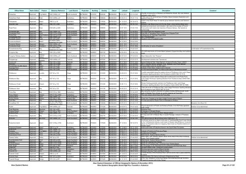
Official Name Name Status Feature Statutory Reference Land District Projection Northing Easting Datum Latitude Longitude Description Comment<br />
Pukewhau Approved Trig Station 1943 (HON) p.27 North Auckland NZTM2000 6125700 1629300 NZGD2000 35 00 39 S 173 19 16 E<br />
Trig NE <strong>of</strong> intersection <strong>of</strong> Waikare and Waiterimu Roads, SE Lake Waikare<br />
(geodetic code: A2LC)<br />
Pukewhero Peak Approved Peak 1933 (HON) p.27 Canterbury NZTM2000 5179700 1399500 NZGD2000 43 30 31 S 170 31 11 E<br />
A little east <strong>of</strong> the terminal face <strong>of</strong> Godley Glacier between Separation and<br />
McKinnon Streams<br />
Pukuparara Approved Island 1966 (1) p.18 Southland NZTM2000 4756300 1179500 NZGD2000 47 12 43 S 167 26 47 E<br />
Island in the South West Titi Islands group between Kaimohu and Solomon<br />
Islands<br />
Pukutahi Lake Approved Lake 1949 (22) p.858 Southland NZTM2000 5054300 1197900 NZGD2000 44 33 08 S 167 56 15 E Between Lake Never-never and Te Hau Peak, upper Harrison River area<br />
Isolated and prominent rock formation, 3km west <strong>of</strong> the locality <strong>of</strong> French<br />
Pulpit Rock Approved Rock 2008 (84) p.2290 Canterbury NZTM2000 5151600 1589600 NZGD2000 43 47 19 S 172 52 15 E Farm at the north-west inner reaches <strong>of</strong> Akaroa Harbour. Not named on<br />
current map<br />
Pumanawa Bay Approved Bay 1943 (HON) p.27 North Auckland NZTM2000 6123500 1670800 NZGD2000 35 01 43 S 173 46 34 E Into which flows the Waipahiki Creek<br />
Pumanawa Point Approved Point 1994 (133) p.4349 North Auckland NZTM2000 6149500 1636300 NZGD2000 34 47 46 S 173 23 49 E Point NE <strong>of</strong> Taumatara Point. Change from Waipapa Point<br />
Pump Pool Approved River Feature 1990 (191) p.4192 South Auckland NZTM2000 5687020 1852540 NZGD2000 38 55 46 S 175 54 48 E Fishing pool on Tauranga Taupo River<br />
Punaatawake Bay Approved Bay 1945 (HON) p.27 Nelson NZTM2000 5486500 1670400 NZGD2000 40 46 10 S 173 50 03 E Not "Punaatawheke"<br />
Punakaiki Cavern Approved Cave 1991 (32) p.687 Nelson NZTM2000 5336500 1462300 NZGD2000 42 06 41 S 171 20 04 E Southern end <strong>of</strong> Punakaiki locality<br />
Punaromia Beach Approved Beach<br />
Te Arawa Lakes<br />
Settlement Act 2006<br />
South Auckland NZTM2000 5765800 1895500 NZGD2000 38 12 26 S 176 22 29 E<br />
Punaruku Estuary Approved Estuary 1943 (HON) p.27 North Auckland NZTM2000 6086800 1719900 NZGD2000 35 21 18 S 174 19 11 E<br />
Punatoetoe Head Approved Headland 1984 (204) p.4798 Otago NZTM2000 4975000 1432600 NZGD2000 45 21 31 S 170 51 46 E Confirmation <strong>of</strong> name <strong>of</strong> headland<br />
Punawhakareia Bay Approved Bay<br />
Te Arawa Lakes<br />
Settlement Act 2006<br />
South Auckland NZTM2000 5782700 1902000 NZGD2000 38 03 11 S 176 26 30 E Confirmation <strong>of</strong> Punawhakareia Bay<br />
Punganui Bay Approved Bay 1964 (79) p.2365 Nelson NZTM2000 5468800 1667700 NZGD2000 40 55 45 S 173 48 15 E<br />
On north-west shore <strong>of</strong> Current Basin between Coppermine Bay and Audibert<br />
Point<br />
Punganui Railway Station Approved<br />
Railway<br />
Station<br />
1928 (HON) p.27 North Auckland NZTM2000 5945000 1732700 NZGD2000 36 37 53 S 174 29 03 E Near Helensville. Not "Pukanui"<br />
Pungapunga Approved<br />
Development<br />
Scheme<br />
1939 (HON) p.27 Taranaki NZTM2000 5692400 1807600 NZGD2000 38 53 34 S 175 23 37 E Development scheme near Taumarunui<br />
Puniho Hill Approved Hill 1964 (79) p.2365 Taranaki NZTM2000 5650200 1688500 NZGD2000 39 17 35 S 174 01 35 E Egmont National Park, West Egmont, at head <strong>of</strong> Puniho Track, 2,832 ft<br />
Punt Arm Approved Bay 1964 (79) p.2365 Nelson NZTM2000 5475700 1670200 NZGD2000 40 52 00 S 173 49 59 E Arm in Greville Harbour between Trigs. "Williams" and "Point George"<br />
Puotewheke (Scuffle Island) Approved Island 1983 (18) p.409 Nelson NZTM2000 5485200 1669300 NZGD2000 40 46 53 S 173 49 17 E Original Māori name for Scuffle Island<br />
Puponga Point Approved Point 1949 (22) p.858 Nelson NZTM2000 5513400 1577600 NZGD2000 40 31 47 S 172 44 08 E Instead <strong>of</strong> Abel Head. Original name restored<br />
Pupuha Island Approved Island 1972 (18) p.379 North Auckland NZTM2000 6027300 1753600 NZGD2000 35 53 11 S 174 42 06 E For the islet approximately 14 chains south-east <strong>of</strong> "Muriwhenua Island"<br />
Pūrākaunui Approved Locality 2007 (4) p.120 Otago NZTM2000 4931000 1415900 NZGD2000 45 45 00 S 170 37 59 E<br />
Pūrākaunui Bay Approved Bay 2007 (4) p.120 Otago NZTM2000 4932300 1415100 NZGD2000 45 44 17 S 170 37 24 E<br />
Pūrākaunui Creek Approved Stream 2007 (4) p.120 Otago NZTM2000 4928800 1415300 NZGD2000 45 46 11 S 170 37 28 E<br />
Locality (populated) along the eastern shore <strong>of</strong> Pūrākaunui Inlet, north Otago<br />
Peninsula. Spelling alteration from Purakaunui (28/05/1992 78:1514)<br />
Coastal bay located between Mapoutahi (coastal point) and Potato Point,<br />
north Otago Peninsula. Spelling alteration from Purakaunui Bay (28/05/1992<br />
78:1514)<br />
Stream flowing generally northerly into Pūrākaunui Inlet, north Otago<br />
Peninsula. Spelling alteration from Purakanui Creek (30/04/1987 62:1964)<br />
Pūrākaunui Inlet Approved Bay 2007 (4) p.120 Otago NZTM2000 4930300 1415100 NZGD2000 45 45 22 S 170 37 21 E<br />
Tidal inlet south <strong>of</strong> Pūrākaunui Bay, north Otago Peninsula. Spelling alteration<br />
from Purakaunui Inlet (28/05/1992 78:1514)<br />
Purau Bay Approved Bay 2003 (73) p.1896 Canterbury NZTM2000 5169100 1579500 NZGD2000 43 37 51 S 172 44 45 E<br />
Bay along the southern shoreline <strong>of</strong> Lyttelton Harbour/Whakaraupō, southeast<br />
<strong>of</strong> Stoddart Point. Shown on current mapping as Purau Bay<br />
Purau Stream Approved Stream 1976 (110) p.2453 Canterbury NZTM2000 5167400 1579500 NZGD2000 43 38 46 S 172 44 45 E The main stream which flows into Purau Bay<br />
Purerua Point Approved Point 1943 (HON) p.27 North Auckland NZTM2000 6109600 1693900 NZGD2000 35 09 08 S 174 01 51 E<br />
Purimu Stream Approved Stream 1975 (62) p.1632 Hawke's Bay NZTM2000 5621400 1932900 NZGD2000 39 29 33 S 176 52 15 E Flows from Taradale to the Main Outfall Channel west <strong>of</strong> Napier<br />
Puriri Bay Approved Bay 1979 (112) p.3715 North Auckland NZTM2000 6085600 1723400 NZGD2000 35 21 55 S 174 21 30 E For bay just south <strong>of</strong> Rocky Point in Whangaruru Harbour<br />
Puroa/Boar Hill Approved Hill<br />
Te Uri o Hau Claims<br />
Settlement Act 2002<br />
North Auckland NZTM2000 6004700 1729300 NZGD2000 36 05 37 S 174 26 11 E Alteration from Boar Hill<br />
Putahi Approved Trig Station 1944 (HON) p.27 Taranaki NZTM2000 5600800 1731200 NZGD2000 39 43 57 S 174 31 52 E<br />
Trig at intersection <strong>of</strong> Putahi and Kaharoa Roads, 5 km NE Patea (geodetic<br />
code: A730)<br />
Position to be determined<br />
Putai Blowhole Approved Blowhole 1991 (32) p.687 Nelson NZTM2000 5336100 1461600 NZGD2000 42 06 54 S 171 19 33 E Dolomite Point<br />
Putangi Stream Approved Stream 1975 (62) p.1632 South Auckland NZTM2000 5812700 1853800 NZGD2000 37 47 52 S 175 52 57 E A tributary <strong>of</strong> Ahimate Stream<br />
Putatara Point Approved Point 1930 (HON) p.27 Southland NZTM2000 4813500 1196900 NZGD2000 46 42 37 S 167 43 33 E The Māori name for Rugged Point, Stewart Island<br />
Putataua Bay Approved Bay 1974 (100) p.2163 North Auckland NZTM2000 6122900 1682700 NZGD2000 35 01 60 S 173 54 24 E<br />
For bay just north <strong>of</strong> Matauri Bay in Cavalli Passage. Instead <strong>of</strong> "Putatawa<br />
Bay"<br />
Putauaki Approved Mountain 1925 (HON) p.27 South Auckland NZTM2000 5775700 1927800 NZGD2000 38 06 25 S 176 44 18 E The <strong>of</strong>ficial name for Mount Edgecumbe (1925 Hon p. 7)<br />
Putauhina Island Approved Island 2001 (149) p.3705 Southland NZTM2000 4755600 1174900 NZGD2000 47 12 55 S 167 23 07 E<br />
Confirmed name for an island north-west <strong>of</strong> Taukihepa/Big South Cape Island<br />
in the Tiri/Muttonbird Islands, south-west <strong>of</strong> Stewart Island/Rakiura. Currently<br />
shown as Putauhina Island on mapping. Also known as Putahina Island and<br />
Hidden Island<br />
Putauhina Nuggets Approved Island 1966 (1) p.18 Southland NZTM2000 4753900 1173200 NZGD2000 47 13 46 S 167 21 40 E Islets south-west <strong>of</strong> Putauhina Island in the South West Titi Islands<br />
Putiki Point Approved Point 1941 (HON) p.27 Hawke's Bay NZTM2000 5661100 2028200 NZGD2000 39 05 39 S 177 57 01 E<br />
Putoetoe Approved Trig Station 1944 (HON) p.27 Hawke's Bay NZTM2000 5656100 2022200 NZGD2000 39 08 31 S 177 53 04 E Instead <strong>of</strong> Putoitoi and Puto-oe-a-Patua<br />
Putoetoe Point Approved Point 1973 (15) p.365 South Auckland NZTM2000 5814700 1764200 NZGD2000 37 48 01 S 174 51 54 E Coastal point at Raglan<br />
Puwerewere Point Approved Point 1988 (93) p.2239 South Auckland NZTM2000 5828500 1902200 NZGD2000 37 38 27 S 176 25 30 E Motiti Island. Feature <strong>Names</strong> (Points)<br />
Puweto Valley Approved Valley 1967 (4) p.120 North Auckland NZTM2000 6072200 1757900 NZGD2000 35 28 52 S 174 44 26 E<br />
Wide valley, with northerly aspect, which forms most <strong>of</strong> the area <strong>of</strong> Aorangi<br />
Island, Poor Knights Islands<br />
Position to be determined<br />
Puwhatawhata Point Approved Point 1988 (93) p.2239 South Auckland NZTM2000 5831900 1899700 NZGD2000 37 36 40 S 176 23 43 E Motiti Island. Feature <strong>Names</strong> (Points)<br />
Puwheke Approved Hill 1994 (133) p.4349 North Auckland NZTM2000 6142400 1630500 NZGD2000 34 51 37 S 173 20 01 E Small Hill. Change from Puheke<br />
Puwheke Beach Approved Beach 1994 (133) p.4349 North Auckland NZTM2000 6142200 1628100 NZGD2000 34 51 44 S 173 18 27 E Beach W <strong>of</strong> Puwheke (Hill). Correction from Puheke Beach<br />
Pyke Gorge Approved Gorge 1975 (62) p.1632 Westland NZTM2000 5081900 1224500 NZGD2000 44 19 09 S 168 17 29 E For the gorge on the Pyke River by its confluence with Red Pyke River<br />
Pykes Hill Approved Hill 1999 (4) p.134 Otago NZTM2000 5070500 1286200 NZGD2000 44 27 02 S 169 03 22 E Hill above Bells Creek. Confirming current usage<br />
Pylon Gully Approved Valley 1964 (79) p.2365 Canterbury NZTM2000 5234600 1494900 NZGD2000 43 02 02 S 171 42 35 E Running east-west, south <strong>of</strong> Mount Horrible<br />
Pyramid Col Approved Col 1938 (HON) p.28 Otago NZTM2000 5056800 1239700 NZGD2000 44 33 07 S 168 27 50 E Between Osonzac Twins and Mount Clarke<br />
Pyramid Creek Approved Stream 1966 (1) p.18 Nelson NZTM2000 5436800 1547900 NZGD2000 41 13 07 S 172 22 42 E<br />
A small tributary <strong>of</strong> the Karamea River, with its source near a peak called the<br />
Pyramid<br />
Pyramid Peak Approved Peak 1957 (91) p.2304 Southland NZTM2000 5022700 1205700 NZGD2000 44 50 24 S 168 00 40 E Approximately 120 chains north-west <strong>of</strong> Ngatimamoe Peak<br />
Pyramid Range Approved Range 1970 (10) p.297 Nelson NZTM2000 5439900 1573400 NZGD2000 41 11 31 S 172 40 58 E<br />
From Trig. Tableland, on the Peel Range, and extending through Gordons<br />
Pyramid to junction with Arthur Range<br />
<strong>New</strong> <strong>Zealand</strong> <strong>Names</strong><br />
<strong>New</strong> <strong>Zealand</strong> <strong>Gazetteer</strong> <strong>of</strong> Official Geographic <strong>Names</strong> (8 <strong>November</strong> <strong>2011</strong>)<br />
<strong>New</strong> <strong>Zealand</strong> Geographic Board Ngā Pou Taunaha o Aotearoa Page 81 <strong>of</strong> 120


