

Gazetteer of New Zealand Names - 3 November 2011
Gazetteer of New Zealand Names - 3 November 2011
Gazetteer of New Zealand Names - 3 November 2011

You also want an ePaper? Increase the reach of your titles
YUMPU automatically turns print PDFs into web optimized ePapers that Google loves.
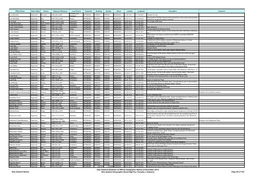
Official Name Name Status Feature Statutory Reference Land District Projection Northing Easting Datum Latitude Longitude Description Comment<br />
Low Mountain Approved Mountain 1949 (22) p.858<br />
Canterbury &<br />
Westland<br />
NZTM2000 5186200 1505500 NZGD2000 43 28 16 S 171 49 54 E Instead <strong>of</strong> Lowe<br />
Low Neck Bay Approved Bay 1964 (79) p.2365 Nelson NZTM2000 5483600 1679900 NZGD2000 40 47 41 S 173 56 50 E<br />
Bay between Old Man Point and the intersection <strong>of</strong> the south-west boundary<br />
<strong>of</strong> Section 10 with the eastern shoreline<br />
Low Peak Approved Peak 1974 (100) p.2163 Canterbury NZTM2000 5167500 1369000 NZGD2000 43 36 35 S 170 08 15 E For a peak <strong>of</strong> Mt Cook<br />
Lower Birch Pool Approved River Feature 1987 (163) p.4458 Wellington NZTM2000 5677350 1843430 NZGD2000 39 01 08 S 175 48 42 E<br />
Lower Farm Stream Approved Stream 1974 (11) p.233 Canterbury NZTM2000 5237300 1503300 NZGD2000 43 00 39 S 171 48 48 E<br />
Lower Tindill Stream Approved Stream 1970 (10) p.297 Canterbury NZTM2000 5171600 1406600 NZGD2000 43 35 01 S 170 36 16 E Map reference<br />
Lows Terrace Approved Terrace 1986 (89) p.2487 Otago NZTM2000 5022100 1258400 NZGD2000 44 52 21 S 168 40 31 E Terrace beside the Shotover River<br />
Lucas Glacier Approved Glacier 1969 (8) p.240 Otago NZTM2000 5076800 1264200 NZGD2000 44 23 03 S 168 47 04 E<br />
On the south-eastern aspect <strong>of</strong> main divide from Moncrieff Peak to Rainbow<br />
Col<br />
Lucas Heights Approved Suburb 2007 (138) p.3623 North Auckland NZTM2000 5933300 1749500 NZGD2000 36 44 03 S 174 40 28 E<br />
North Shore City Suburb centred around NZMG coordinate 2660000E<br />
6495100N<br />
Lucifer Stream Approved Stream 1971 (13) p.259 Canterbury NZTM2000 5175100 1398400 NZGD2000 43 32 59 S 170 30 16 E Tributary <strong>of</strong> Godley River<br />
Luckens Point Approved Point 2005 (45) p.1115 North Auckland NZTM2000 5924000 1746800 NZGD2000 36 49 07 S 174 38 45 E<br />
Coastal point at the western reaches <strong>of</strong> Waitemata Harbour in West<br />
Auckland. Spelling correction from Lucken Point<br />
Lucknow Saddle Approved Saddle 1934 (HON) p.15 Canterbury NZTM2000 5199200 1414700 NZGD2000 43 20 14 S 170 42 51 E Unmapped. At the head <strong>of</strong> the Rangitata<br />
Lucky Bay Approved Bay 1983 (18) p.409 Nelson NZTM2000 5472900 1672400 NZGD2000 40 53 30 S 173 51 34 E Confirmation <strong>of</strong> name <strong>of</strong> bay<br />
Lucky Beach Approved Beach 1941 (HON) p.15 Southland NZTM2000 4814600 1213200 NZGD2000 46 42 36 S 167 56 21 E Stewart Island<br />
Lucky Point Approved Point 1966 (1) p.18 Southland NZTM2000 4814800 1213500 NZGD2000 46 42 31 S 167 56 36 E South <strong>of</strong> Lucky Beach. North east coast <strong>of</strong> Stewart Island<br />
Lucretia Stream Approved Stream 1974 (11) p.233 Canterbury NZTM2000 5298400 1546100 NZGD2000 42 27 54 S 172 20 40 E<br />
Lucy Walker Pass Approved Pass 1936 (HON) p.15 Westland NZTM2000 5159700 1356100 NZGD2000 43 40 32 S 169 58 28 E<br />
From the Head <strong>of</strong> the Horace Walker Glacier to the neve <strong>of</strong> the Douglas<br />
Glacier<br />
Lucys Gully Approved Valley 1994 (133) p.4349 Taranaki NZTM2000 5666100 1681200 NZGD2000 39 09 02 S 173 56 23 E Gully in NW Kaitake Range<br />
Lumaluma Creek Approved Stream 1932 (HON) p.15 Southland NZTM2000 4906400 1111700 NZGD2000 45 49 22 S 166 42 49 E In Chalky Sound. This name is in lieu <strong>of</strong> Left Hand Branch<br />
Lumber Flat Approved Flat 1975 (62) p.1632 Westland NZTM2000 5094000 1253200 NZGD2000 44 13 29 S 168 39 29 E Large river flat on the Arawata River<br />
Luna Creek Approved Stream 1950 (4) p.39 Otago NZTM2000 5014700 1245100 NZGD2000 44 55 57 S 168 30 08 E Flowing north-east from Lake Luna into Moonlight Creek<br />
Luna Ridge Approved Ridge 1970 (10) p.297 Nelson NZTM2000 5420600 1555700 NZGD2000 41 21 54 S 172 28 13 E<br />
Extending north-east from Mount Luna, on the Arthur Range, to the Crow<br />
River. Forms divide between Crow River and Karamea River<br />
Luncheon Col Approved Col 1986 (89) p.2487 Otago NZTM2000 5050000 1236200 NZGD2000 44 36 40 S 168 24 54 E Confirmation <strong>of</strong> position north <strong>of</strong> Leary Peak. Also <strong>of</strong>ficial by 1938 Hon p. 15<br />
Luncheon Cove Approved Cove 1963 (76) p.1921 Southland NZTM2000 4911700 1096300 NZGD2000 45 45 51 S 166 31 19 E<br />
Dusky Sound. On the south-eastern coast <strong>of</strong> Anchor Island. This name<br />
originally given by Captain Cook is to be reinstated on maps<br />
Lunik Creek Approved Stream 1966 (1) p.18 Nelson NZTM2000 5419200 1553500 NZGD2000 41 22 39 S 172 26 38 E A tributary <strong>of</strong> the Karamea River in the vicinity <strong>of</strong> Mount Luna<br />
Luscombe Stream Approved Stream 1968 (9) p.268 Canterbury NZTM2000 5096500 1430000 NZGD2000 44 15 54 S 170 52 12 E<br />
Lyell Peak Approved Peak 1943 (HON) p.15 Canterbury NZTM2000 5243100 1480400 NZGD2000 42 57 19 S 171 32 01 E South <strong>of</strong> Avalanche Peak<br />
Lyell Range Approved Range 1970 (10) p.297 Nelson NZTM2000 5383000 1530500 NZGD2000 41 42 06 S 172 09 53 E<br />
Extending from above the Buller River, through Mount Lyell, to the southern<br />
end <strong>of</strong> the Matiri Range at "<strong>New</strong>ton Ridge" junction<br />
Lynches Flat Approved Flat 1974 (11) p.233 Westland NZTM2000 5296100 1519600 NZGD2000 42 28 60 S 172 01 18 E A river flat on Robinson River<br />
Lynfield Cove Approved Bay 1979 (112) p.3715 North Auckland NZTM2000 5911700 1752200 NZGD2000 36 55 42 S 174 42 32 E Small bay at mouth <strong>of</strong> Duck Creek<br />
Lynmore Post Office Approved Post Office 1950 (70) p.1989 South Auckland NZTM2000 5772400 1888500 NZGD2000 38 09 01 S 176 17 32 E At Lewis' Hill, 'Rotorua<br />
Lyttelton Harbour/Whakaraupō Approved Harbour<br />
Ngāi Tahu Claims<br />
Settlement Act 1998<br />
Canterbury NZTM2000 5171800 1582900 NZGD2000 43 36 24 S 172 47 17 E Alteration from Lyttelton Harbour<br />
Lyttles Farm Approved Flat 1943 (HON) p.15 Southland NZTM2000 5026900 1206600 NZGD2000 44 48 10 S 168 01 32 E In lieu <strong>of</strong> Monkey Flat<br />
Macalister Cove Approved Cove 1957 (91) p.2304 Marlborough NZTM2000 5436800 1692700 NZGD2000 41 12 54 S 174 06 21 E<br />
On eastern side <strong>of</strong> Blackwood Bay, Queen Charlotte Sound. Fronting Lots 8,<br />
9 and 10, D.P. 1071, Block II, Arapawa Survey District<br />
Macandrew Bay Approved Bay 1927 (HON) p.15 Otago NZTM2000 4917700 1413500 NZGD2000 45 52 08 S 170 35 50 E In the Otago Harbour. Not "Macandrew's"<br />
Macfarlane Stream Approved Stream 1985 (18) p.404 Canterbury NZTM2000 5202300 1501200 NZGD2000 43 19 32 S 171 46 53 E Correct name for the west branch <strong>of</strong> Kowai River<br />
MacGregor Stream Approved Stream 1968 (9) p.268 Canterbury NZTM2000 5083300 1412400 NZGD2000 44 22 46 S 170 38 42 E<br />
Mackay Basin Approved Basin 1970 (10) p.297 Canterbury NZTM2000 5173400 1409400 NZGD2000 43 34 05 S 170 38 23 E Hill formation just north-west <strong>of</strong> Mount Chevalier<br />
Mackay Point Approved Point 1985 (155) p.3636 North Auckland NZTM2000 6026900 1759200 NZGD2000 35 53 21 S 174 45 50 E Western point <strong>of</strong> Coppermine Island. Change <strong>of</strong> spelling only.<br />
Mackay Rocks Approved Ridge 1996 (94) p.2470 Taranaki NZTM2000 5649600 1691800 NZGD2000 39 17 53 S 174 03 53 E Rock ridge running from crater towards Kapuni Gorge as on Infomap 273-09<br />
Mackenzie Creek Approved Stream 2005 (177) p.4510 Westland NZTM2000 5128900 1335100 NZGD2000 43 56 43 S 169 41 57 E<br />
Stream flowing north from Mount Mackenzie into the Landsborough River in<br />
the Southern Alps/Kā Tiritiri o te Moana. Spelling alteration from McKenzie<br />
Creek<br />
Mackenzie Pass/Manahuna Approved Pass<br />
Ngāi Tahu Claims<br />
Settlement Act 1998<br />
Canterbury NZTM2000 5103900 1409000 NZGD2000 44 11 35 S 170 36 36 E Alteration from Mackenzie Pass<br />
Mackenzie Stream Approved Stream 1984 (1) p.24 Otago NZTM2000 4845900 1340900 NZGD2000 46 29 26 S 169 37 26 E Name for stream<br />
Mackintosh Spur Approved Ridge 1958 (73) p.1731 Hawke's Bay NZTM2000 5640500 1894000 NZGD2000 39 20 06 S 176 24 40 E<br />
Running south-easterly from Kaiarahi Trig. Station between Donald and<br />
Tutaekuri Rivers<br />
Mackintosh Stream Approved Stream 1972 (18) p.379 Canterbury NZTM2000 5121400 1414900 NZGD2000 44 02 14 S 170 41 23 E A tributary <strong>of</strong> the Opihi River flowing from the Two Thumb Range<br />
Mackintosh Stream Approved Stream 1992 (169) p.3464 Canterbury NZTM2000 5128100 1446700 NZGD2000 43 59 03 S 171 05 18 E<br />
Tributary <strong>of</strong> Waihi River, Waihi Gorge. Changed spelling from MacIntosh<br />
Stream 26/02/1970 10:297<br />
Macleod Stream Approved Stream 1982 (76) p.2163 Canterbury NZTM2000 5056700 1393500 NZGD2000 44 36 48 S 170 23 51 E Name <strong>of</strong> stream flowing into Deep Stream<br />
MacPherson Cirque Approved Cirque 1969 (8) p.240 Otago NZTM2000 5067400 1262800 NZGD2000 44 28 05 S 168 45 39 E At the head <strong>of</strong> Old Homestead Creek<br />
Macrae Point Approved Point 1970 (10) p.297 Southland NZTM2000 4794500 1229500 NZGD2000 46 53 58 S 168 08 07 E At south coast, Halfmoon Bay, just west <strong>of</strong> Lonnekers Point<br />
Madagascar Beach Approved Beach 1984 (204) p.4798 Southland NZTM2000 5065100 1191000 NZGD2000 44 27 06 S 167 51 35 E Amendment <strong>of</strong> position from 830360<br />
Madeline Creek Approved Stream 1968 (9) p.268 Southland NZTM2000 4794400 1229600 NZGD2000 46 54 02 S 168 08 12 E Tributary <strong>of</strong> Hollyford River draining from Mount Madeline<br />
Madman Stream Approved Stream 1950 (4) p.39 Southland NZTM2000 5048100 1210200 NZGD2000 44 36 53 S 168 05 14 E<br />
North-east <strong>of</strong> Spot Hill Ridge between Caswell and George Sounds. Flows<br />
south-east into Stillwater River<br />
Madrid Hill Approved Hill 1974 (11) p.233 Canterbury NZTM2000 5245500 1550700 NZGD2000 42 56 30 S 172 23 45 E<br />
Maerewhenua Approved Locality 1953 (3) p.87 Otago NZTM2000 5023900 1411400 NZGD2000 44 54 48 S 170 36 38 E Instead <strong>of</strong> Maruwenua or Maruwhenua<br />
Maerewhenua Post Office Approved Post Office 1953 (3) p.87 Otago NZTM2000 5024000 1411400 NZGD2000 44 54 45 S 170 36 39 E Instead <strong>of</strong> Maruwenua or Maruwhenua<br />
Maerewhenua River Approved River 1953 (3) p.87 Otago NZTM2000 5023900 1411400 NZGD2000 44 54 48 S 170 36 38 E Instead <strong>of</strong> Maruwenua or Maruwhenua<br />
Maerewhenua Settlement Approved Settlement 1953 (3) p.87 Otago NZTM2000 5024500 1413000 NZGD2000 44 54 30 S 170 37 52 E Instead <strong>of</strong> Maruwenua or Maruwhenua<br />
Magazine Bay Approved Bay 1984 (1) p.24 Canterbury NZTM2000 5171000 1575800 NZGD2000 43 36 49 S 172 42 00 E Bay located between Lyttelton and Corsair Bay<br />
Magill Stream Approved Stream 1974 (100) p.2163 South Auckland NZTM2000 5830400 1846000 NZGD2000 37 38 26 S 175 47 17 E<br />
A tributary <strong>of</strong> the Waihou River. Instead <strong>of</strong> "McGill Stream" (26/11/1953<br />
67:1920)<br />
Magnetic Beach Approved Beach 1941 (HON) p.15 Southland NZTM2000 4800800 1224900 NZGD2000 46 50 26 S 168 04 49 E Beach in Port William/Potirepo, Rakiura/Stewart Island<br />
Magog Peak Approved Peak 1941 (HON) p.15 Southland NZTM2000 4800700 1224900 NZGD2000 46 50 29 S 168 04 49 E Local name for one <strong>of</strong> the Fraser Peaks<br />
Mahanga Range Approved Range 1970 (10) p.297 Nelson NZTM2000 5347700 1570300 NZGD2000 42 01 20 S 172 38 29 E Extending from Mount Misery to Mount Mahanga in the Spenser Mountains<br />
<strong>New</strong> <strong>Zealand</strong> <strong>Names</strong><br />
<strong>New</strong> <strong>Zealand</strong> <strong>Gazetteer</strong> <strong>of</strong> Official Geographic <strong>Names</strong> (8 <strong>November</strong> <strong>2011</strong>)<br />
<strong>New</strong> <strong>Zealand</strong> Geographic Board Ngā Pou Taunaha o Aotearoa Page 49 <strong>of</strong> 120


