

Gazetteer of New Zealand Names - 3 November 2011
Gazetteer of New Zealand Names - 3 November 2011
Gazetteer of New Zealand Names - 3 November 2011

Create successful ePaper yourself
Turn your PDF publications into a flip-book with our unique Google optimized e-Paper software.
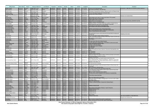
Official Name Name Status Feature Statutory Reference Land District Projection Northing Easting Datum Latitude Longitude Description Comment<br />
Holder Lookout Approved Lookout 1988 (206) p.5173 North Auckland NZTM2000 5919030 1767850 NZGD2000 36 51 35 S 174 52 58 E Lookout end <strong>of</strong> Glendowie Road Corrigendum: 1988 206:5173 (correcting location reference)<br />
Hole in the Hill Approved Arch 1987 (62) p.1964 Nelson NZTM2000 5354400 1473700 NZGD2000 41 57 08 S 171 28 34 E Arch south <strong>of</strong> Charleston, near Nile River<br />
Holland Creek Approved Stream 1975 (62) p.1632 Westland NZTM2000 5080900 1234000 NZGD2000 44 19 58 S 168 24 34 E A tributary <strong>of</strong> Cascade River between "Malcolm Creek" and "Retreat Creek"<br />
Holloway Peak Approved Peak 1940 (HON) p.10 Otago NZTM2000 5076200 1234000 NZGD2000 44 22 30 S 168 24 22 E To the north-east <strong>of</strong> Temple and on the same ridge<br />
Hollowback Ridge Approved Ridge 1950 (70) p.1989 Hawke's Bay NZTM2000 5613800 1884800 NZGD2000 39 34 42 S 176 18 57 E Lying to north <strong>of</strong> Big Hill Stream<br />
Hollyford River/Whakaitpu Kā<br />
Tuka<br />
Approved River<br />
Ngāi Tahu Claims<br />
Settlement Act 1998<br />
Southland NZTM2000 5049900 1211900 NZGD2000 44 35 58 S 168 06 36 E Alteration from Hollyford River<br />
Holman Point Approved Point 1970 (10) p.297 North Auckland NZTM2000 6026800 1760500 NZGD2000 35 53 24 S 174 46 42 E South-eastern point, about 15 chains south-east <strong>of</strong> "The Landing"<br />
Holmes Stream Approved Stream 1976 (110) p.2453 Canterbury NZTM2000 5163900 1590600 NZGD2000 43 40 40 S 172 53 00 E Stream which flows into Holmes Bay<br />
Holyoake Clearing Approved Clearing 1968 (9) p.268 Nelson NZTM2000 5464700 1600800 NZGD2000 40 58 08 S 173 00 34 E In the vicinity <strong>of</strong> Trig. X (1,915 ft)<br />
Home Hills Approved Hill 1989 (62) p.1435 Otago NZTM2000 5023400 1358100 NZGD2000 44 54 06 S 169 56 10 E Rolling hills 10 km E St Bathans Changed from Home Hill by 2/08/1990 132:2739<br />
Homebush Ridge Approved Ridge 1970 (10) p.297 Canterbury NZTM2000 5187300 1517900 NZGD2000 43 27 46 S 171 59 06 E Ridge in vicinity <strong>of</strong> Homebush locality<br />
Homer Saddle Approved Saddle 1949 (22) p.858 Otago & Southland NZTM2000 5031500 1202600 NZGD2000 44 45 34 S 167 58 44 E<br />
Instead <strong>of</strong> Homer's. The name Homer's for a saddle in Hollyford Survey<br />
District about four miles south <strong>of</strong> Lake Alabaster is expunged<br />
Homestead Creek Approved Stream 1986 (89) p.2487 Otago NZTM2000 5067100 1266700 NZGD2000 44 28 21 S 168 48 34 E Creek feed from the slopes <strong>of</strong> Homestead Peak<br />
Homestead Spur Approved Ridge 1985 (155) p.3636 Marlborough NZTM2000 5316000 1644300 NZGD2000 42 18 25 S 173 32 15 E Spur between Cribb Creek and Snowflake Stream<br />
Homestead Stream Approved Stream 1974 (11) p.233 Canterbury NZTM2000 5260700 1533100 NZGD2000 42 48 12 S 172 10 55 E<br />
Honeycomb Hill Arch Approved Arch 1985 (155) p.3636 Nelson NZTM2000 5447400 1532200 NZGD2000 41 07 19 S 172 11 32 E Northern-most limestone arch crossing Oparara River<br />
Honeymoon Bay Approved Bay 1973 (15) p.365 Wellington NZTM2000 5477400 1763600 NZGD2000 40 50 17 S 174 56 26 E Bay on east coast approximately 1 mile south <strong>of</strong> Waiorua Bay<br />
Honeymoon Creek Approved Stream 1985 (18) p.404 Canterbury NZTM2000 5251100 1620300 NZGD2000 42 53 33 S 173 14 55 E Name <strong>of</strong> creek flowing to north <strong>of</strong> Domett<br />
Honeymoon Stream Approved Stream 1989 (120) p.3005 North Auckland NZTM2000 5909100 1732200 NZGD2000 36 57 18 S 174 29 06 E<br />
Hongoeka Approved Locality 2010 (173) p.4271 Wellington NZTM2000 5452900 1756400 NZGD2000 41 03 36 S 174 51 41 E<br />
NZTopo50 BP31-Porirua, GR 553 528 and NZTopo50 BP32-Paraparaumu,<br />
GR 564 529.<br />
Assigning a new name.<br />
Hood Glacier Approved Glacier 1969 (8) p.240 Otago NZTM2000 5072400 1261600 NZGD2000 44 25 21 S 168 44 56 E On the north-eastern slopes <strong>of</strong> Mount Avalanche<br />
Hooker Lake Approved Lake 1998 (1) p.78 Canterbury NZTM2000 5159200 1366600 NZGD2000 43 41 01 S 170 06 15 E<br />
Lake, a new feature formed at the base <strong>of</strong> the Hooker Glacier near Mt Cook.<br />
Not named on current mapping<br />
Hookey Knob Approved Hill Feature 1974 (11) p.233 Canterbury NZTM2000 5167200 1470700 NZGD2000 43 38 13 S 171 23 49 E A hill feature<br />
Hooper Ridge Approved Ridge 1974 (11) p.233 Marlborough NZTM2000 5385500 1667100 NZGD2000 41 40 46 S 173 48 22 E<br />
Hope Col Approved Col 1992 (78) p.1513 Otago NZTM2000 5147000 1355300 NZGD2000 43 47 23 S 169 57 31 E On Main Divide 300m NW <strong>of</strong> Mouth Hopkins<br />
Hopuhopu Approved Locality 1986 (89) p.2487 South Auckland NZTM2000 5831900 1791000 NZGD2000 37 38 25 S 175 09 53 E Locality adjoining the Waikato River. Confirmation <strong>of</strong> name as one word<br />
Horace Greeley Slip Approved Slip 1986 (89) p.2487 Otago NZTM2000 5016800 1257200 NZGD2000 44 55 10 S 168 39 24 E Large slip beside the Shotover River<br />
Horama Stream Approved Stream 1989 (120) p.3005 North Auckland NZTM2000 5908400 1732800 NZGD2000 36 57 40 S 174 29 30 E Tributary <strong>of</strong> Glen Esk Stream<br />
Horehore Approved High Point 1980 (66) p.1752 Wellington NZTM2000 5670400 1847800 NZGD2000 39 04 49 S 175 51 53 E For high point to east <strong>of</strong> Rangipo<br />
Horeke Approved Locality 1949 (22) p.858 North Auckland NZTM2000 6087200 1654000 NZGD2000 35 21 25 S 173 35 40 E Not "Horoeke"<br />
Horewai Point Approved Point 1941 (HON) p.10 Wellington NZTM2000 5420800 1838100 NZGD2000 41 19 45 S 175 50 43 E Not "Horiwi"<br />
Hornes Ridge Approved Ridge 1944 (HON) p.10 Wellington NZTM2000 5422700 1757200 NZGD2000 41 19 55 S 174 52 43 E<br />
Ridge running NE from Mount Cameron, Pencarrow Head (geodetic code:<br />
8801)<br />
Horoera Approved Locality 1941 (HON) p.11 Gisborne NZTM2000 5820000 2082900 NZGD2000 37 38 25 S 178 28 17 E Not "Horowera"<br />
Horoera Stream Approved Stream 1941 (HON) p.11 Gisborne NZTM2000 5820000 2082900 NZGD2000 37 38 25 S 178 28 17 E Not "Horowera"<br />
Horokaretu Stream Approved Stream 1973 (15) p.365 South Auckland NZTM2000 5802600 1778200 NZGD2000 37 54 24 S 175 01 37 E Tributary <strong>of</strong> Orongo Stream<br />
Horokiri Stream Approved Stream 1956 (17) p.406 Wellington NZTM2000 5454500 1764100 NZGD2000 41 02 39 S 174 57 09 E<br />
Rises near Wainui Trig. Station in Block, and flows generally south-westerly<br />
into Porirua Harbour. Instead <strong>of</strong> Horokiwi<br />
Horomaka Island Approved Island 1949 (22) p.858 Canterbury NZTM2000 5167000 1586400 NZGD2000 43 38 60 S 172 49 53 E Instead <strong>of</strong> Horomonga<br />
Confirmed dual name for an island near the mouth <strong>of</strong> the Lords<br />
Horomamae/Owen Island Approved Island 2001 (149) p.3705 Southland NZTM2000 4769700 1232400 NZGD2000 47 07 25 S 168 09 11 E<br />
River/Tūtaekawetoweto, Stewart Island/Rakiura. Updating to current dual<br />
naming format from "Horomamae Island (Owen)" shown on mapping and<br />
<strong>of</strong>ficial by 15/01/1998 1:78<br />
Horomanga Railway Station Approved<br />
Railway<br />
Station<br />
1954 (80) p.2088 South Auckland NZTM2000 5747300 1927800 NZGD2000 38 21 45 S 176 45 05 E On Murupara Branch Railway<br />
Horrellville Approved Locality 1970 (10) p.297 Canterbury NZTM2000 5201200 1545600 NZGD2000 43 20 24 S 172 19 44 E<br />
Locality approximately 9 miles south-east <strong>of</strong> Oxford. In Eyre County. Not<br />
"Horrelville"<br />
Horse Spur Approved Ridge 1992 (169) p.3464 Canterbury NZTM2000 5139800 1456400 NZGD2000 43 52 51 S 171 12 45 E Spur runs N from Little Mount Peel<br />
Horseshoe Approved Basin 1985 (18) p.404 Nelson NZTM2000 5437800 1573800 NZGD2000 41 12 39 S 172 41 15 E For name <strong>of</strong> mountain basin below Mount Arthur No.2<br />
Horseshoe Bends Approved Bend 1966 (1) p.18 Canterbury NZTM2000 5211600 1516200 NZGD2000 43 14 37 S 171 58 04 E<br />
In the Waimakariri Gorge between where Fosters Creek and Coal Creek<br />
enter the Waimakariri River<br />
Horseshoe Lagoon Approved Lagoon 1969 (8) p.240 Wellington NZTM2000 5437000 1803200 NZGD2000 41 11 34 S 175 25 23 E Blocks V and IX, Huangarua Survey District<br />
Horseshoe Nugget Approved Island 1971 (13) p.259 Southland NZTM2000 4796800 1229800 NZGD2000 46 52 45 S 168 08 28 E The islet at the northern headland <strong>of</strong> the entrance to Horseshoe Bay<br />
Horseshoe Stream Approved Stream 1974 (11) p.233 Canterbury NZTM2000 5257300 1546800 NZGD2000 42 50 06 S 172 20 57 E<br />
Hospital Flat Approved Flat 1974 (11) p.233 Westland NZTM2000 5299800 1521400 NZGD2000 42 27 01 S 172 02 39 E A river flat on upper Grey River<br />
Hossack River Approved River 1944 (HON) p.11 Canterbury NZTM2000 5303900 1604000 NZGD2000 42 25 02 S 173 02 55 E<br />
Hot Rock Stream Approved Stream 1968 (9) p.268 Marlborough NZTM2000 5355200 1607900 NZGD2000 41 57 19 S 173 05 43 E Block VIII, Molesworth Survey District<br />
Hotahika Stream Approved Stream 1953 (67) p.1920 South Auckland NZTM2000 5849100 1836500 NZGD2000 37 28 29 S 175 40 28 E<br />
Flows from Section 23, Block V, through Lots 2, 3, 6, 5, 8, 12, D.P. 13241,<br />
into Waihou River<br />
Houghton Gully Approved Valley 1989 (120) p.3005 North Auckland NZTM2000 5915700 1731000 NZGD2000 36 53 44 S 174 28 13 E Flows into Lake Wainamu<br />
Houheria Stream Approved Stream 1989 (120) p.3005 North Auckland NZTM2000 5922100 1731200 NZGD2000 36 50 16 S 174 28 17 E Tributary <strong>of</strong> Mokoroa Stream. Change from Hoheria Stream<br />
Houhora Approved Locality 1938 (HON) p.11 North Auckland NZTM2000 6149700 1609300 NZGD2000 34 47 42 S 173 06 06 E<br />
Houhora Approved Trig Station 1938 (HON) p.11 North Auckland NZTM2000 6149600 1609500 NZGD2000 34 47 45 S 173 06 14 E<br />
Houhora East Approved Locality 1953 (3) p.87 North Auckland NZTM2000 6149700 1609700 NZGD2000 34 47 42 S 173 06 22 E Instead <strong>of</strong> Hohoura East<br />
Houhora Harbour Approved Locality 1938 (HON) p.11 North Auckland NZTM2000 6149300 1611700 NZGD2000 34 47 54 S 173 07 40 E<br />
Houhora Post Office Approved Post Office 1987 (196) p.5081 North Auckland NZTM2000 6146600 1610200 NZGD2000 34 49 22 S 173 06 42 E <strong>New</strong> location for Post Office in Pukenui. South <strong>of</strong> Houhora<br />
Houhora West Approved Locality 1953 (3) p.87 North Auckland NZTM2000 6146500 1613300 NZGD2000 34 49 25 S 173 08 44 E Instead <strong>of</strong> Hohoura West<br />
Houhou Approved Locality 1944 (HON) p.11 Westland NZTM2000 5271300 1435700 NZGD2000 42 41 36 S 170 59 39 E Instead <strong>of</strong> Ho Ho<br />
Houhou Creek Approved Stream 1944 (HON) p.11 Westland NZTM2000 5269700 1437500 NZGD2000 42 42 29 S 171 00 57 E Instead <strong>of</strong> Ho Ho<br />
Houhou Railway Station Approved<br />
Railway<br />
Station<br />
1944 (HON) p.11 Westland NZTM2000 5271400 1435500 NZGD2000 42 41 32 S 170 59 31 E Instead <strong>of</strong> Ho Ho<br />
House Hill Approved Hill 1974 (100) p.2163 Canterbury NZTM2000 5102000 1385400 NZGD2000 44 12 13 S 170 18 51 E Site <strong>of</strong> Trig P<br />
Howard Lake Approved Lake 1953 (3) p.86 Canterbury NZTM2000 5169100 1443000 NZGD2000 43 36 52 S 171 03 16 E Instead <strong>of</strong> Lake Camp Lake Camp reinstated by 13/02/1969 8:240<br />
Howells Point/Taramea Approved Point<br />
Ngāi Tahu Claims<br />
Settlement Act 1998<br />
Southland NZTM2000 4851200 1218600 NZGD2000 46 23 06 S 168 02 23 E Alteration from Howells Point<br />
Howitt Bay Approved Bay 1984 (1) p.24 Westland NZTM2000 5281700 1474500 NZGD2000 42 36 25 S 171 28 12 E Bay to south <strong>of</strong> Crooked River mouth in Lake Brunner<br />
Howitt Peak Approved Peak 1987 (163) p.4458 Canterbury NZTM2000 5268200 1512700 NZGD2000 42 44 01 S 171 56 01 E Peak overlooking the Hurunui River, west <strong>of</strong> Lake Sumner<br />
<strong>New</strong> <strong>Zealand</strong> <strong>Names</strong><br />
<strong>New</strong> <strong>Zealand</strong> <strong>Gazetteer</strong> <strong>of</strong> Official Geographic <strong>Names</strong> (8 <strong>November</strong> <strong>2011</strong>)<br />
<strong>New</strong> <strong>Zealand</strong> Geographic Board Ngā Pou Taunaha o Aotearoa Page 34 <strong>of</strong> 120


