

Gazetteer of New Zealand Names - 3 November 2011
Gazetteer of New Zealand Names - 3 November 2011
Gazetteer of New Zealand Names - 3 November 2011

You also want an ePaper? Increase the reach of your titles
YUMPU automatically turns print PDFs into web optimized ePapers that Google loves.
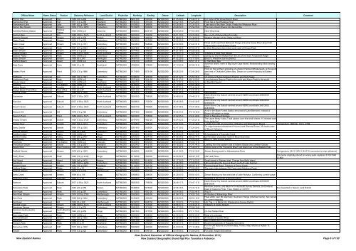
Official Name Name Status Feature Statutory Reference Land District Projection Northing Easting Datum Latitude Longitude Description Comment<br />
Barron Flat Approved Flat 1985 (18) p.404 Nelson NZTM2000 5451700 1580900 NZGD2000 41 05 09 S 172 46 21 E For name <strong>of</strong> flat above Barron River<br />
Barrowman Flat Approved Flat 1971 (13) p.259 Westland NZTM2000 5194700 1391300 NZGD2000 43 22 18 S 170 25 26 E River flat <strong>of</strong> the Whataroa River<br />
Barrowman Lake Approved Lake 1987 (62) p.1964 Westland NZTM2000 5183900 1389800 NZGD2000 43 28 06 S 170 24 05 E Lake west <strong>of</strong> the Main Divide. Feeds the Whataroa River<br />
Barrys Bay Stream Approved Stream 1976 (110) p.2453 Canterbury NZTM2000 5153900 1592600 NZGD2000 43 46 04 S 172 54 29 E The main stream flowing into Barrys Bay<br />
Bartletts Railway Station Approved<br />
Railway<br />
Station<br />
1944 (HON) p.3 Gisborne NZTM2000 5689500 2025100 NZGD2000 38 50 26 S 177 53 49 E Near Wharerata<br />
Bartrum Bay Approved Bay 1988 (206) p.5173 North Auckland NZTM2000 5920200 1726500 NZGD2000 36 51 20 S 174 25 08 E Bay south <strong>of</strong> Muriwai Beach locality<br />
Bartrum Stream Approved Stream 1972 (18) p.379 Nelson NZTM2000 5355000 1489300 NZGD2000 41 56 57 S 171 39 52 E Western tributary <strong>of</strong> the Ohika-nui River<br />
Basin Creek Approved Stream 1974 (11) p.233 Canterbury NZTM2000 5303000 1547900 NZGD2000 42 25 25 S 172 22 00 E<br />
Basin Creek Approved Stream 1958 (73) p.1731 Canterbury NZTM2000 5303800 1548600 NZGD2000 42 24 59 S 172 22 31 E<br />
Flows south-east from Birdwood Range and joins Avoca River about 120<br />
chains below Amphitheatre Creek<br />
Basin Peak Approved Peak 1957 (91) p.2304 Southland NZTM2000 5027800 1198700 NZGD2000 44 47 25 S 167 55 37 E In Wick Mountains two miles south-west <strong>of</strong> Cirque Peak<br />
Basin Stream Approved Stream 1974 (11) p.233 Canterbury NZTM2000 5074400 1396500 NZGD2000 44 27 18 S 170 26 32 E<br />
Basket Stream Approved Stream 1989 (120) p.3005 North Auckland NZTM2000 5905000 1732400 NZGD2000 36 59 31 S 174 29 16 E Tributary <strong>of</strong> Opal Pool Stream<br />
Bastion Peaks Approved Peak 1943 (HON) p.3 Canterbury NZTM2000 5203800 1438900 NZGD2000 43 18 05 S 171 00 50 E Jutting out into the Rakaia from the arc <strong>of</strong> the main Arrowsmith Ridge<br />
Bates Stream Approved Stream 1969 (8) p.240 Wellington NZTM2000 5454100 1793300 NZGD2000 41 02 29 S 175 17 59 E Block V, Waiohine Survey District<br />
Bathing Beach Approved Beach 1941 (HON) p.3 Southland NZTM2000 4795100 1228900 NZGD2000 46 53 38 S 168 07 41 E In Half Moon Bay<br />
Bats Cave Approved Cave 1966 (1) p.18 Southland NZTM2000 4755000 1178900 NZGD2000 47 13 24 S 167 26 14 E<br />
Solomon Island, north <strong>of</strong> Big South Cape Island. Muttonbirding block landing<br />
place<br />
Point on the northern shoreline <strong>of</strong> Lyttelton Harbour/Whakaraupō, at the south<br />
Battery Point Approved Point 2003 (73) p.1896 Canterbury NZTM2000 5171900 1579100 NZGD2000 43 36 20 S 172 44 28 E west end <strong>of</strong> Otokitoki/Gollans Bay. Shown on current mapping as Battery<br />
Point<br />
Battleaxe Approved Col 1963 (76) p.1921 Canterbury NZTM2000 5198000 1425200 NZGD2000 43 21 02 S 170 50 35 E On Armoury Range between Amazon and Nym Peaks<br />
Battlement Peak Approved Peak 1940 (HON) p.3 Otago NZTM2000 5077400 1224100 NZGD2000 44 21 33 S 168 16 59 E Lying between Beacon Peak to the north and Alison Peak to the south<br />
Bauza Island Approved Island 1939 (HON) p.3 Southland NZTM2000 4966700 1122800 NZGD2000 45 17 27 S 166 54 52 E In Doubtful Sound<br />
Bawbaw Approved Trig Station 1944 (HON) p.3 Wellington NZTM2000 5435000 1778500 NZGD2000 41 13 00 S 175 07 46 E<br />
Baylys Beach Approved Locality 1953 (3) p.87 North Auckland NZTM2000 6021300 1667500 NZGD2000 35 57 01 S 173 44 54 E<br />
Baylys Beach Post Office Approved Post Office 1953 (3) p.87 North Auckland NZTM2000 6021300 1667500 NZGD2000 35 57 01 S 173 44 54 E<br />
Baynes Creek Approved Stream 1989 (62) p.1435 Otago NZTM2000 4918770 1414550 NZGD2000 45 51 35 S 170 36 40 E <strong>New</strong> spelling<br />
Bayswater Approved Suburb 2007 (138) p.3623 North Auckland NZTM2000 5924300 1758500 NZGD2000 36 48 50 S 174 46 37 E<br />
North Shore City Suburb centred around NZMG coordinate 2669000E<br />
6486000N<br />
Bayview Approved Suburb 2007 (138) p.3623 North Auckland NZTM2000 5928800 1752500 NZGD2000 36 46 28 S 174 42 32 E<br />
North Shore City Suburb centred around NZMG coordinate 2663000E<br />
6490600N<br />
Beach Haven Approved Suburb 2007 (138) p.3623 North Auckland NZTM2000 5926100 1750800 NZGD2000 36 47 56 S 174 41 25 E<br />
North Shore City Suburb centred around NZMG coordinate 2661300E<br />
6487850N<br />
Beacon Hill Approved Hill 1978 (13) p.422 Canterbury NZTM2000 5077300 1386800 NZGD2000 44 25 34 S 170 19 18 E<br />
A hill in the Black Forest Station area east <strong>of</strong> Lake Benmore. Instead <strong>of</strong><br />
Brown Hill shown on maps<br />
Beacon Point Approved Point 1988 (206) p.5173 North Auckland NZTM2000 5900200 1735600 NZGD2000 37 02 05 S 174 31 29 E Point in Manukau Entrance<br />
Bealey Chasm Approved Chasm 1990 (132) p.2739 Canterbury NZTM2000 5247640 1482120 NZGD2000 42 54 53 S 171 33 21 E<br />
The Upper Bealy Valley Track passes over this small chasm, 10 minutes walk<br />
from Jacks Hut<br />
Bealey Spur Approved Locality 1991 (53) p.1213 Canterbury NZTM2000 5234800 1488400 NZGD2000 43 01 53 S 171 37 48 E Locality 5 km SE <strong>of</strong> conjunction <strong>of</strong> Bealey and Waimakariri Rivers Corrigendum: 1990 No. 132 p. 2739<br />
Beau Saddle Approved Saddle 1964 (79) p.2365 Canterbury NZTM2000 5261900 1555000 NZGD2000 42 47 39 S 172 26 59 E<br />
On ridge between tributaries <strong>of</strong> Hurunui and Glenrae Rivers, 35 chains west<br />
<strong>of</strong> Mount Catherine<br />
Beckett Stream Approved Stream 1968 (9) p.268 Canterbury NZTM2000 5250600 1513800 NZGD2000 42 53 32 S 171 56 39 E<br />
Bedford Valley Approved Valley 1938 (HON) p.3 Otago NZTM2000 5050400 1234000 NZGD2000 44 36 24 S 168 23 16 E At headwaters <strong>of</strong> Cascade Creek<br />
Bedford Valley Approved Valley 1986 (89) p.2487 Otago NZTM2000 5050000 1234700 NZGD2000 44 36 38 S 168 23 47 E Confirmation <strong>of</strong> position north <strong>of</strong> Mount Earnslaw<br />
Beef Creek Approved Stream 1969 (8) p.240 Wellington NZTM2000 5452700 1808300 NZGD2000 41 03 01 S 175 28 43 E Block X, Tiffin Survey District<br />
Beehives Approved Trig Station 1944 (HON) p.3 Taranaki NZTM2000 5644900 1690900 NZGD2000 39 20 26 S 174 03 17 E<br />
Beelzebub Glacier Approved Glacier 1962 (73) p.2021 Westland NZTM2000 5202400 1413100 NZGD2000 43 18 29 S 170 41 44 E Leading from the eastern side <strong>of</strong> Adams Glacier into Lambert Glacier<br />
Beggs Pool Approved River Feature 1987 (163) p.4458 Wellington NZTM2000 5665030 1844000 NZGD2000 39 07 47 S 175 49 22 E Fishing pool on the Tongaririo River, just down river <strong>of</strong> the Waikato Falls<br />
Belfield Stream Approved Stream 1979 (42) p.1553 Canterbury NZTM2000 5049000 1405200 NZGD2000 44 41 09 S 170 32 30 E Stream flowing south to Hakataramea River Corrigendum: 29/11/1979 112:3715 (correction to map reference)<br />
Belfry Peak Approved Peak 1990 (191) p.4192 Otago NZTM2000 5114000 1340000 NZGD2000 44 04 52 S 169 45 10 E NW Lake Ohau<br />
Bell Island Approved Island 1996 (94) p.2470 Nelson NZTM2000 5428700 1614500 NZGD2000 41 17 35 S 173 10 23 E Small island in Waimea Inlet. Change from Bells Island<br />
Bell Knoll Approved Hill 1987 (163) p.4458 Canterbury NZTM2000 5263900 1531600 NZGD2000 42 46 28 S 172 09 50 E Hill overlooking the Hurunui River, south <strong>of</strong> Lake Sumner<br />
Bellard Creek Approved Stream 1964 (79) p.2365 Westland NZTM2000 5114000 1340100 NZGD2000 44 04 52 S 169 45 14 E Paringa-Haast Road. Tributary <strong>of</strong> Grave Creek<br />
Bellbird Ridge Approved Ridge 1966 (1) p.18 Nelson NZTM2000 5461000 1527300 NZGD2000 40 59 56 S 172 08 08 E The main ridge between Pitt Creek and Wekakura Creek<br />
Bellbird Stream Approved Stream 1974 (11) p.233 Marlborough NZTM2000 5308400 1643700 NZGD2000 42 22 32 S 173 31 51 E<br />
Bells Creek Approved Stream 1999 (4) p.134 Otago NZTM2000 5068800 1288000 NZGD2000 44 28 00 S 169 04 40 E Stream flowing into the west side <strong>of</strong> Lake Wanaka. Confirming current usage<br />
This name originally placed on wrong peak, replaces 31/03/1949<br />
22:860.<br />
Belltopper Falls Approved Waterfall 1966 (1) p.18 Southland NZTM2000 4764400 1197900 NZGD2000 47 09 03 S 167 41 44 E Waterfall at the mouth <strong>of</strong> Pegasus River<br />
Belmont Approved Suburb 2007 (138) p.3623 North Auckland NZTM2000 5925300 1759500 NZGD2000 36 48 17 S 174 47 17 E<br />
North Shore City Suburb centred around NZMG coordinate 2670000E<br />
6487000N<br />
Belvedere Peak Approved Peak 1949 (22) p.858 Nelson NZTM2000 5338600 1576900 NZGD2000 42 06 16 S 172 43 14 E<br />
Rainbow, Sabine, and Block IV in Humboldt Survey Districts. On Divide at<br />
head <strong>of</strong> Clarence River. Topo. Station Z. 6,916 ft<br />
Also Gazetted in Nelson Land District<br />
Ben Hope Approved Peak 1970 (10) p.297 Canterbury NZTM2000 5172300 1430100 NZGD2000 43 34 58 S 170 53 44 E Trig. X.<br />
Ben More Stream Approved Stream 1974 (100) p.2163 Marlborough NZTM2000 5352900 1683200 NZGD2000 41 58 17 S 174 00 15 E A tributary <strong>of</strong> Kekerangu River<br />
Ben Ross Approved Peak 1999 (64) p.1492 Canterbury NZTM2000 5125400 1350400 NZGD2000 43 58 56 S 169 53 16 E<br />
Peak 2486, near Mt Glenmary, Naumann Range (intended name). Not named<br />
on current mapping<br />
Benbown Approved Hill 1968 (9) p.268 Marlborough NZTM2000 5424000 1648700 NZGD2000 41 20 02 S 173 34 55 E Hill, Trig. J, in Block XIII, Wakamarina Survey District<br />
Bendall Creek Approved Stream 1988 (206) p.5173 North Auckland NZTM2000 5910200 1741500 NZGD2000 36 56 37 S 174 35 21 E Tributary <strong>of</strong> Oratia Stream<br />
Bendrose Stream Approved Stream 1974 (11) p.233 Canterbury NZTM2000 5092300 1371500 NZGD2000 44 17 12 S 170 08 10 E<br />
Benmore Hydro-electric<br />
Scheme<br />
Approved<br />
Hydro-Electric<br />
1949 (22) p.858<br />
Scheme<br />
Otago NZTM2000 5061500 1377500 NZGD2000 44 33 56 S 170 11 53 E On the Waitaki River<br />
Ben-nagar Peak Approved Peak 1938 (HON) p.3 Otago NZTM2000 5052400 1248200 NZGD2000 44 35 44 S 168 34 03 E West <strong>of</strong> Lochnagar<br />
Bennett Stream Approved Stream 1975 (62) p.1632 Canterbury NZTM2000 5276900 1620500 NZGD2000 42 39 36 S 173 15 00 E A tributary <strong>of</strong> Leader River<br />
Bens Bay Approved Bay 1966 (1) p.18 Southland NZTM2000 4761100 1196000 NZGD2000 47 10 46 S 167 40 03 E Bay in North Arm, Port Pegasus<br />
Benson Peak Approved Peak 1966 (1) p.18 Southland NZTM2000 4803200 1200500 NZGD2000 46 48 17 S 167 45 50 E Southernmost peak <strong>of</strong> Ruggedy Mountains<br />
Benvenue Cliffs Approved Cliff 1975 (62) p.1632 Canterbury NZTM2000 5083960 1460290 NZGD2000 44 23 03 S 171 14 46 E<br />
For the cliff features at Caroline Bay, Timaru. Map reference NZMS 17,<br />
Timaru, F7<br />
Berard Approved Peak 1978 (13) p.422 Canterbury NZTM2000 5146700 1599100 NZGD2000 43 49 58 S 172 59 20 E For peak (height 806 metres)<br />
<strong>New</strong> <strong>Zealand</strong> <strong>Names</strong><br />
<strong>New</strong> <strong>Zealand</strong> <strong>Gazetteer</strong> <strong>of</strong> Official Geographic <strong>Names</strong> (8 <strong>November</strong> <strong>2011</strong>)<br />
<strong>New</strong> <strong>Zealand</strong> Geographic Board Ngā Pou Taunaha o Aotearoa Page 6 <strong>of</strong> 120


