

Gazetteer of New Zealand Names - 3 November 2011
Gazetteer of New Zealand Names - 3 November 2011
Gazetteer of New Zealand Names - 3 November 2011

You also want an ePaper? Increase the reach of your titles
YUMPU automatically turns print PDFs into web optimized ePapers that Google loves.
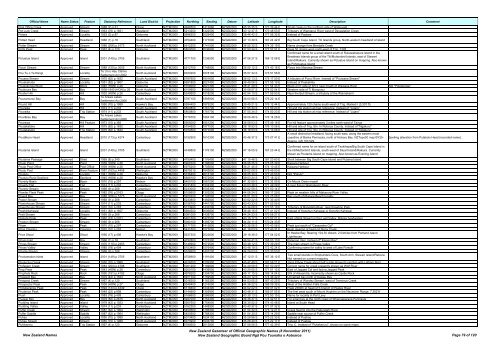
Official Name Name Status Feature Statutory Reference Land District Projection Northing Easting Datum Latitude Longitude Description Comment<br />
Post Office Creek Approved Stream 1988 (2) p.31 Otago NZTM2000 4948500 1417660 NZGD2000 45 35 35 S 170 39 44 E Small creek on the northern side <strong>of</strong> Waikouaiti<br />
Pot Luck Creek Approved Stream 1963 (76) p.1921 Westland NZTM2000 5213200 1422500 NZGD2000 43 12 47 S 170 48 53 E Tributary <strong>of</strong> Wanganui River west <strong>of</strong> Devastation Creek<br />
Potara Approved Locality 1953 (3) p.87 Gisborne NZTM2000 5696200 2029400 NZGD2000 38 46 42 S 177 56 32 E Instead <strong>of</strong> Paotara<br />
Potted Head Approved Headland 1966 (1) p.18 Southland NZTM2000 4754400 1177000 NZGD2000 47 13 39 S 167 24 42 E Big South Cape Island. Titi Islands group. North-western headland <strong>of</strong> island<br />
Potter Stream Approved Stream 1988 (206) p.5173 North Auckland NZTM2000 5912200 1741500 NZGD2000 36 55 32 S 174 35 19 E Name change from Bendalls Creek<br />
Potts Peak Approved Peak 1967 (4) p.120 Gisborne NZTM2000 5800000 2036900 NZGD2000 37 50 34 S 177 57 51 E Peak 50 chains west-north-west <strong>of</strong> Trig. 1328<br />
Confirmed name for a small island south <strong>of</strong> Rukawahakura Island in the<br />
Potuatua Island Approved Island 2001 (149) p.3705 Southland NZTM2000 4771700 1236000 NZGD2000 47 06 27 S 168 12 08 E<br />
Breaksea Islands group <strong>of</strong> the Titi/Muttonbird Islands, east <strong>of</strong> Stewart<br />
Island/Rakiura. Currently shown as Potuatua Island on mapping. Also known<br />
as Pohotuatua Island<br />
Poturi Stream Approved Stream 1989 (120) p.3005 North Auckland NZTM2000 5912700 1748900 NZGD2000 36 55 12 S 174 40 18 E Flows into Manawa Stream<br />
Pou Tu o Te Rangi Approved Locality<br />
Te Uri o Hau Claims<br />
Settlement Act 2002<br />
North Auckland NZTM2000 6020200 1678100 NZGD2000 35 57 34 S 173 51 58 E<br />
Pouaea Stream Approved Stream 1975 (62) p.1632 South Auckland NZTM2000 5787600 1801600 NZGD2000 38 02 13 S 175 17 50 E A tributary <strong>of</strong> Punui River. Instead <strong>of</strong> "Pouwaea Stream"<br />
Pouakahutia Approved Locality 1951 (82) p.1607 Gisborne NZTM2000 5691800 2027400 NZGD2000 38 49 08 S 177 55 19 E Instead <strong>of</strong> Poakahitia<br />
Poukokonga Block Approved Block 1940 (HON) p.26 Gisborne NZTM2000 5706000 2027300 NZGD2000 38 41 29 S 177 54 43 E Block on E side <strong>of</strong> SH 2 near mouth <strong>of</strong> Waipaoa River Not "Pokokonga"<br />
Poukoura Bay Approved Bay 1936-1940 (HON) p.26 North Auckland NZTM2000 6109900 1695500 NZGD2000 35 08 57 S 174 02 54 E Western side <strong>of</strong> Ti Mangonui<br />
Poulter Hill Approved Hill 1932 (HON) p.26 Canterbury NZTM2000 5249500 1518200 NZGD2000 42 54 10 S 171 59 53 E Near the Bull Stream, a tributary <strong>of</strong> the Waimakariri<br />
Pounamunui Bay Approved Bay<br />
Te Arawa Lakes<br />
Settlement Act 2006<br />
South Auckland NZTM2000 5787100 1895900 NZGD2000 38 00 56 S 176 22 14 E<br />
Pound Hill Approved Hill 1950 (70) p.1989 Hawke's Bay NZTM2000 5594400 1875200 NZGD2000 39 45 21 S 176 12 44 E Approximately 120 chains south-west <strong>of</strong> Trig. Marked I (3,307 ft)<br />
Pouraika Approved Hill 1974 (11) p.233 South Auckland NZTM2000 5800800 1761700 NZGD2000 37 55 34 S 174 50 23 E Hill and trig station at map reference. Instead <strong>of</strong> "Ligars"<br />
Pouraika Approved Trig Station 1974 (11) p.233 South Auckland NZTM2000 5800800 1761700 NZGD2000 37 55 34 S 174 50 23 E Hill and trig station at map reference. Instead <strong>of</strong> "Ligars"<br />
Pourākau Bay Approved Bay<br />
Te Arawa Lakes<br />
Settlement Act 2006<br />
South Auckland NZTM2000 5776700 1884100 NZGD2000 38 06 46 S 176 14 26 E<br />
Pourewa Approved Hill Feature 1973 (15) p.365 South Auckland NZTM2000 5905000 1851200 NZGD2000 36 58 03 S 175 49 18 E For hill feature approximately 3 miles north-west <strong>of</strong> Tairua<br />
Poutakataka Approved Hill 1975 (62) p.1632 South Auckland NZTM2000 5754500 1877000 NZGD2000 38 18 53 S 176 10 06 E Hill and site <strong>of</strong> Trig. Stn. In Rotorua County. Instead <strong>of</strong> "Ngakuru"<br />
Poutakataka Approved Trig Station 1975 (62) p.1632 South Auckland NZTM2000 5754500 1877000 NZGD2000 38 18 53 S 176 10 06 E Hill and site <strong>of</strong> Trig. Stn. In Rotorua County. Instead <strong>of</strong> "Ngakuru"<br />
A small distinctive headland, facing south-east, along the eastern-most<br />
Poutākoro Head Approved Headland 2010 (173) p.4274 Canterbury NZTM2000 5152900 1610300 NZGD2000 43 46 37 S 173 07 41 E coastline <strong>of</strong> Banks Peninsula, north <strong>of</strong> Hickory Bay. NZTopo50 map BY25-<br />
Akaroa, GR 103 529.<br />
Spelling alteration from Putakolo Head (recorded name).<br />
Poutama Island Approved Island 2001 (149) p.3705 Southland NZTM2000 4749800 1176100 NZGD2000 47 16 05 S 167 23 44 E<br />
Confirmed name for an island south <strong>of</strong> Taukihepa/Big South Cape Island in<br />
the titi/Muttonbird Islands, south-west <strong>of</strong> Stuart Island/Rakiura. Currently<br />
shown as Poutama Island on mapping. Also known as Evening Island<br />
Poutama Passage Approved Strait 1969 (8) p.240 Southland NZTM2000 4750400 1176400 NZGD2000 47 15 46 S 167 23 60 E Strait between Big South Cape Island and Putama Island<br />
Pouto Point Approved Point 1939 (HON) p.26 North Auckland NZTM2000 5909700 1786500 NZGD2000 36 56 25 S 175 05 39 E Kaipara Harbour<br />
Pouto Post Office Approved Post Office 1939 (HON) p.26 North Auckland NZTM2000 5975200 1705800 NZGD2000 36 21 45 S 174 10 45 E Kaipara Harbour<br />
Poutu Pool Approved River Feature 1987 (163) p.4458 Wellington NZTM2000 5675510 1843800 NZGD2000 39 02 08 S 175 49 00 E<br />
Poututu Approved Locality 1941 (HON) p.26 Gisborne NZTM2000 5736400 2013100 NZGD2000 38 25 30 S 177 43 53 E Not "Potutu"<br />
Poututu Rural Sections Approved Sections 1945 (HON) p.26 Hawke's Bay NZTM2000 5668100 1972900 NZGD2000 39 03 24 S 177 18 32 E<br />
Poverty Basin Approved Basin 1970 (10) p.297 Nelson NZTM2000 5400100 1561200 NZGD2000 41 32 59 S 172 32 05 E On Mount Owen massif<br />
Poverty Flat Approved Flat 1974 (11) p.233 Canterbury NZTM2000 5231800 1504300 NZGD2000 43 03 38 S 171 49 29 E A river flat on Waimakariri River<br />
Poverty Stream Approved Stream 1968 (9) p.268 Canterbury NZTM2000 5233000 1505300 NZGD2000 43 02 59 S 171 50 14 E<br />
Powder Flask Peak Approved Peak 1982 (76) p.2163 Otago NZTM2000 5109600 1303200 NZGD2000 44 06 24 S 169 17 29 E Peak on western hills <strong>of</strong> Makarora River Valley<br />
Powell Bay Approved Bay 1988 (206) p.5173 North Auckland NZTM2000 5920200 1726500 NZGD2000 36 51 20 S 174 25 08 E Bay south <strong>of</strong> Muriwai Beach locality<br />
Power Stream Approved Stream 1968 (9) p.268 Canterbury NZTM2000 5233800 1482800 NZGD2000 43 02 22 S 171 33 40 E<br />
Powerhouse Stream Approved Stream 1974 (11) p.233 Canterbury NZTM2000 5156700 1441700 NZGD2000 43 43 33 S 171 02 05 E<br />
Powerhouse Stream Approved Stream 1970 (10) p.297 Canterbury NZTM2000 5173900 1432200 NZGD2000 43 34 08 S 170 55 19 E Tributary <strong>of</strong> Rangitata River, near Erewhon Park<br />
Powhirikahawai Approved Locality 1951 (82) p.1607 Gisborne NZTM2000 5694500 2006800 NZGD2000 38 48 16 S 177 41 02 E Instead <strong>of</strong> Kopohuri Kahawai or Konohiri Kahawai<br />
Pratt Stream Approved Stream 1968 (9) p.268 Canterbury NZTM2000 5081000 1438700 NZGD2000 44 24 23 S 170 58 27 E<br />
Prelude Peak Approved Peak 1962 (73) p.2021 Canterbury NZTM2000 5201300 1427500 NZGD2000 43 19 17 S 170 52 21 E East <strong>of</strong> Kirk Stream in the Lyell Valley, Rakaia headwaters<br />
Preston Stream Approved Stream 1968 (9) p.268 Canterbury NZTM2000 5080100 1393700 NZGD2000 44 24 11 S 170 24 33 E<br />
Priam Approved Peak 1970 (10) p.297 Canterbury NZTM2000 5171700 1415800 NZGD2000 43 35 06 S 170 43 06 E Peak just south <strong>of</strong> "Cassandra Col"<br />
Price Clearing Approved Clearing 1970 (10) p.297 Nelson NZTM2000 5431500 1577000 NZGD2000 41 16 03 S 172 43 31 E Bush clearing at head od Stony Creek<br />
Price Shoal Approved Shoal 1956 (17) p.406 Hawke's Bay NZTM2000 5637300 2022600 NZGD2000 39 18 38 S 177 54 02 E<br />
In Hawke Bay. Bearing 104.30 distant, 2.04miles from Portland Island<br />
Lighthouse<br />
Prices Inlet Approved Bay 1966 (1) p.18 Southland NZTM2000 4792800 1223300 NZGD2000 46 54 41 S 168 03 10 E Paterson Inlet. Instead <strong>of</strong>":Kaipipi Bay"<br />
Prices Stream Approved Stream 1976 (110) p.2453 Canterbury NZTM2000 5149900 1572500 NZGD2000 43 48 12 S 172 39 29 E The main stream in Prices Valley<br />
Prices Valley Approved Valley 1985 (18) p.404 Canterbury NZTM2000 5153400 1576400 NZGD2000 43 46 19 S 172 42 24 E Confirming name for valley to west <strong>of</strong> Lake Forsyth<br />
Pringle Stream Approved Stream 1968 (9) p.268 Canterbury NZTM2000 5076900 1402200 NZGD2000 44 26 03 S 170 30 53 E<br />
Proclamation Islets Approved Island 2001 (149) p.3705 Southland NZTM2000 4756900 1191400 NZGD2000 47 12 51 S 167 36 12 E<br />
Two small islands in Shipbuilders Cove, South Arm, Stewart Island/Rakiura.<br />
Not named on current mapping<br />
Productus Creek Approved Stream 1950 (70) p.1989 Southland NZTM2000 4916200 1209300 NZGD2000 45 47 49 S 167 58 21 E Joins Elbow Creek about half a mile above its junction with Letham Burn<br />
Pr<strong>of</strong>essor Creek Approved Stream 1984 (204) p.4798 Southland NZTM2000 5061200 1189800 NZGD2000 44 29 09 S 167 50 29 E Correct name for creek presently shown as Wolf River<br />
Prop Peak Approved Peak 1943 (HON) p.26 Canterbury NZTM2000 5200100 1439500 NZGD2000 43 20 05 S 171 01 12 E East <strong>of</strong> Jagged Col and facing Jagged Peak<br />
Prophets Rock Approved Rock 1990 (191) p.4192 Otago NZTM2000 4978200 1304700 NZGD2000 45 17 15 S 169 14 04 E SW <strong>of</strong> Alexandra. Incorrectly shown as Castle Rock<br />
Prospect Bay Approved Bay 1979 (42) p.1553 North Auckland NZTM2000 5971700 1759500 NZGD2000 36 23 12 S 174 46 42 E Unnamed bay north <strong>of</strong> Kawau Bay<br />
Prospect Creek Approved Stream 1967 (4) p.120 Southland NZTM2000 5016300 1183300 NZGD2000 44 53 05 S 167 43 25 E Tributary <strong>of</strong> Worsley Stream, west <strong>of</strong> Terminus Creek<br />
Prospector Peak Approved Peak 1938 (HON) p.27 Otago NZTM2000 5049400 1216000 NZGD2000 44 36 22 S 168 09 39 E West <strong>of</strong> the Hidden Falls Creek<br />
Protuberance Peak Approved Peak 1994 (133) p.4349 Otago NZTM2000 5118400 1334300 NZGD2000 44 02 22 S 169 41 02 E Peak 2389m at head <strong>of</strong> S branch <strong>of</strong> Huxley River<br />
Prudence Peak Approved Peak 1949 (22) p.858 Canterbury NZTM2000 5144900 1355900 NZGD2000 43 48 31 S 169 57 55 E The first peak south <strong>of</strong> Mount Hopkins on the Neumann Range. 7,352 ft<br />
Puari Approved Locality 1983 (18) p.409 Canterbury NZTM2000 5166600 1586900 NZGD2000 43 39 13 S 172 50 15 E Name for locality in Port Levy<br />
Puawai Bay Approved Bay 1978 (82) p.2675 North Auckland NZTM2000 5947000 1753300 NZGD2000 36 36 37 S 174 42 51 E For small bay at the north coast <strong>of</strong> Whangaparaoa Peninsula<br />
Pudding Island Approved Island 1979 (42) p.1553 North Auckland NZTM2000 5957600 1754900 NZGD2000 36 30 52 S 174 43 48 E Island at South Head<br />
Pudding Valley Approved Valley 1974 (11) p.233 Canterbury NZTM2000 5162300 1448900 NZGD2000 43 40 37 S 171 07 32 E<br />
Puffer Creek Approved Stream 1987 (62) p.1964 Wellington NZTM2000 5450500 1785300 NZGD2000 41 04 32 S 175 12 21 E Creek flowing into the Pakuratahi River<br />
Puffer Saddle Approved Saddle 1987 (62) p.1964 Wellington NZTM2000 5450500 1788300 NZGD2000 41 04 30 S 175 14 29 E Saddle near source <strong>of</strong> Puffer Creek<br />
Puhau Approved Locality 1950 (70) p.1989 North Auckland NZTM2000 6073400 1634100 NZGD2000 35 28 56 S 173 22 33 E Instead <strong>of</strong> Puahau<br />
Puhau Stream Approved Stream 1950 (70) p.1989 North Auckland NZTM2000 6073900 1633700 NZGD2000 35 28 40 S 173 22 17 E Instead <strong>of</strong> Puahau<br />
Puhikereru Approved Trig Station 1967 (4) p.120 Gisborne NZTM2000 5785600 2013800 NZGD2000 37 58 58 S 177 42 39 E Trig. C. Instead <strong>of</strong> "Pukekeruru", shown on some maps<br />
<strong>New</strong> <strong>Zealand</strong> <strong>Names</strong><br />
<strong>New</strong> <strong>Zealand</strong> <strong>Gazetteer</strong> <strong>of</strong> Official Geographic <strong>Names</strong> (8 <strong>November</strong> <strong>2011</strong>)<br />
<strong>New</strong> <strong>Zealand</strong> Geographic Board Ngā Pou Taunaha o Aotearoa Page 79 <strong>of</strong> 120


