

Gazetteer of New Zealand Names - 3 November 2011
Gazetteer of New Zealand Names - 3 November 2011
Gazetteer of New Zealand Names - 3 November 2011

Create successful ePaper yourself
Turn your PDF publications into a flip-book with our unique Google optimized e-Paper software.
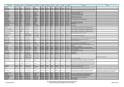
Official Name Name Status Feature Statutory Reference Land District Projection Northing Easting Datum Latitude Longitude Description Comment<br />
Trinity Pass Approved Pass 1975 (62) p.1632 Otago NZTM2000 5075100 1233500 NZGD2000 44 23 05 S 168 23 56 E Situated at western extremity <strong>of</strong> Trinity Glacier. Also <strong>of</strong>ficial by 1941 Hon p. 37<br />
Trinity Stream Approved Stream 1968 (9) p.268 Canterbury NZTM2000 5246900 1505100 NZGD2000 42 55 29 S 171 50 14 E<br />
Trinity Stream Approved Stream 1989 (216) p.6107 North Auckland NZTM2000 5914400 1732300 NZGD2000 36 54 26 S 174 29 06 E Correction to spelling <strong>of</strong> name from Trinty Stream (13/07/1989 120:3005)<br />
Triplex Creek Approved Stream 1950 (70) p.1989 Hawke's Bay NZTM2000 5590300 1874500 NZGD2000 39 47 35 S 176 12 21 E Rising near Armstrong Saddle and flowing easterly into Mangataura Stream<br />
Trireme Peak Approved Peak 1943 (HON) p.37 Canterbury NZTM2000 5195800 1414700 NZGD2000 43 22 04 S 170 42 47 E Highest peak on Cloudy Peak Range<br />
Triton Peak Approved Peak 1979 (42) p.1553 Southland NZTM2000 5016500 1205600 NZGD2000 44 53 44 S 168 00 18 E Peak to east <strong>of</strong> Glade Pass<br />
Trojan Stream Approved Stream 1970 (10) p.297 Canterbury NZTM2000 5172600 1413000 NZGD2000 43 34 34 S 170 41 03 E Tributary <strong>of</strong> North East Gorge Stream<br />
Trolove Stream Approved Stream 1984 (204) p.4798 Marlborough NZTM2000 5343400 1659200 NZGD2000 42 03 33 S 173 42 56 E Name for tributary <strong>of</strong> Clarence River<br />
Troloves Stream Approved Stream 1974 (11) p.233 Marlborough NZTM2000 5383800 1673500 NZGD2000 41 41 39 S 173 52 60 E<br />
Trotters Creek Approved Stream 1984 (204) p.4798 Otago NZTM2000 4970800 1431400 NZGD2000 45 23 46 S 170 50 45 E Confirmation <strong>of</strong> name <strong>of</strong> creek<br />
Trout Stream Approved Stream 1979 (42) p.1553 Canterbury NZTM2000 5206000 1530400 NZGD2000 43 17 44 S 172 08 31 E Stream flowing into Coopers Creek<br />
Trout Stream Approved Stream 1974 (11) p.233 Canterbury NZTM2000 5210300 1528500 NZGD2000 43 15 24 S 172 07 09 E<br />
Trudge Col Approved Col 1943 (HON) p.37 Canterbury NZTM2000 5251600 1498100 NZGD2000 42 52 53 S 171 45 08 E Joins the Hawdon with a tributary <strong>of</strong> the Poulter<br />
Trudge Stream Approved Stream 1968 (9) p.268 Canterbury NZTM2000 5253300 1500200 NZGD2000 42 51 59 S 171 46 42 E<br />
Trumper Stream Approved Stream 1974 (11) p.233 Canterbury NZTM2000 5251700 1543300 NZGD2000 42 53 07 S 172 18 20 E<br />
Trumpeter Point Approved Point 1966 (1) p.18 Southland NZTM2000 4788900 1224200 NZGD2000 46 56 48 S 168 03 41 E East <strong>of</strong> Abraham Bay, Paterson Inlet<br />
Tu Araiawa Island (Fin Island) Approved Island 1983 (18) p.409 Nelson NZTM2000 5480100 1665800 NZGD2000 40 49 39 S 173 46 49 E Original Māori name for Fin Island<br />
Tuaheni Point Approved Point 1941 (HON) p.37 Gisborne NZTM2000 5703500 2040800 NZGD2000 38 42 26 S 178 04 06 E Not "Tuahina"<br />
Tuahuru Point Approved Point 1941 (HON) p.37 Hawke's Bay NZTM2000 5661400 2026700 NZGD2000 39 05 32 S 177 55 58 E<br />
Tuakopae Stream Approved Stream 1941 (HON) p.37 South Auckland NZTM2000 5806700 1860900 NZGD2000 37 50 59 S 175 57 55 E Not "Tuakopai"<br />
Tuamarina Approved Locality 1953 (3) p.87 Marlborough NZTM2000 5413000 1680600 NZGD2000 41 25 50 S 173 57 53 E<br />
Instead <strong>of</strong> Tuamarino (19/07/1951 55:1019). Although the form Tuamarina is<br />
not a correct Maori word it is adopted by virtue <strong>of</strong> long local usage.<br />
Tuamarina Post Office Approved Post Office 1953 (3) p.87 Marlborough NZTM2000 5413000 1680600 NZGD2000 41 25 50 S 173 57 53 E<br />
Instead <strong>of</strong> Tuamarino (19/07/1951 55:1019). Although the form Tuamarina is<br />
not a correct Maori word it is adopted by virtue <strong>of</strong> long local usage.<br />
Tuamarina Railway Station Approved<br />
Railway<br />
Station<br />
1953 (3) p.87 Marlborough NZTM2000 5413000 1680600 NZGD2000 41 25 50 S 173 57 53 E<br />
Instead <strong>of</strong> Tuamarino (19/07/1951 55:1019). Although the form Tuamarina is<br />
not a correct Maori word it is adopted by virtue <strong>of</strong> long local usage.<br />
Tuamarina River Approved River 1953 (3) p.87 Marlborough NZTM2000 5415800 1679800 NZGD2000 41 24 19 S 173 57 17 E<br />
Instead <strong>of</strong> Tuamarino. Although the form Tuamarina is not a correct Maori<br />
word it is adopted by virtue <strong>of</strong> long local usage.<br />
Tuarāhiwiroa Point Approved Point<br />
Te Arawa Lakes<br />
Settlement Act 2006<br />
South Auckland NZTM2000 5780600 1891500 NZGD2000 38 04 32 S 176 19 23 E<br />
Tuatara Bay Approved Bay 1974 (100) p.2163 North Auckland NZTM2000 5903600 1874000 NZGD2000 36 58 26 S 176 04 41 E At the north-western shore <strong>of</strong> Ruamahuaiti<br />
Tuatara Pool Approved Pond 1967 (4) p.120 North Auckland NZTM2000 6072600 1758000 NZGD2000 35 28 39 S 174 44 30 E Pool at the source <strong>of</strong> the stream which drains Puweto Valley, Aorangi Island<br />
Tubman Range Approved Range 1970 (10) p.297 Nelson NZTM2000 5468800 1541500 NZGD2000 40 55 47 S 172 18 19 E<br />
Extending from Mount Goul, at junction with Gouland Range, through Tubman<br />
Hill, to the saddle 1/2 mile south-west <strong>of</strong> Mount Teddy<br />
Tucker Creek Approved Stream 1950 (4) p.39 Nelson NZTM2000 5382700 1536700 NZGD2000 41 42 18 S 172 14 21 E Tributary <strong>of</strong> <strong>New</strong>ton River<br />
Tuhawaiki Island Approved Island 1951 (82) p.1607 Otago NZTM2000 4844900 1347800 NZGD2000 46 30 08 S 169 42 47 E Instead <strong>of</strong> Tuawaiki or Tuhawhaiki. Alternative Māori name: Pihao-te-kohia<br />
Tuhawaiki Mountain Approved Mountain 1940 (HON) p.37 Southland NZTM2000 5040300 1209800 NZGD2000 44 41 04 S 168 04 34 E East <strong>of</strong> Taiaroa Peak, Central Darran Mountains<br />
Tuhua Creek Approved Stream 1992 (78) p.1513 Westland NZTM2000 5258200 1449200 NZGD2000 42 48 50 S 171 09 20 E Flows down Mount Tahua into Lake Kaniere S <strong>of</strong> Hans Bay<br />
Tui Stream Approved Stream 1971 (13) p.259 South Auckland NZTM2000 5843500 1841000 NZGD2000 37 31 26 S 175 43 38 E<br />
Flows westerly from Mount Te Aroha in area just north-east <strong>of</strong> Te Aroha<br />
Borough<br />
Tui Stream Approved Stream 1970 (10) p.297 Canterbury NZTM2000 5163800 1432400 NZGD2000 43 39 36 S 170 55 17 E Small tributary <strong>of</strong> Rangitata River<br />
Tui Stream Approved Stream 1987 (163) p.4458 Canterbury NZTM2000 5286600 1547800 NZGD2000 42 34 16 S 172 21 50 E Stream flowing into the Boyle River next to the Lewis Pass Road<br />
Tui Tarn Approved Pond 1987 (163) p.4458 Canterbury NZTM2000 5139300 1394400 NZGD2000 43 52 15 S 170 26 28 E Tarn west <strong>of</strong> Lake Tekapo. Confirmation <strong>of</strong> name already shown on map<br />
Tukemokihi Approved Locality 1951 (82) p.1607 Gisborne NZTM2000 5683900 1999400 NZGD2000 38 54 11 S 177 36 18 E Instead <strong>of</strong> Tukemakihi<br />
Tukino Peak Approved Peak 1945 (HON) p.37 Wellington NZTM2000 5650400 1822200 NZGD2000 39 16 02 S 175 34 32 E 20 chains south-west <strong>of</strong> Te Heu Heu<br />
Tukino Village Approved Village 1969 (8) p.240 Wellington NZTM2000 5649400 1825000 NZGD2000 39 16 32 S 175 36 30 E<br />
On the eastern slope <strong>of</strong> Mount Ruapehu. Instead <strong>of</strong> "Tukino Alpine Village"<br />
(13/01/1966 1:18)<br />
Tumataika Point Approved Point 1988 (93) p.2239 South Auckland NZTM2000 5827900 1900500 NZGD2000 37 38 49 S 176 24 21 E Motiti Island<br />
Tumbledown Bay Approved Bay 1936 (HON) p.37 Marlborough NZTM2000 5425700 1698300 NZGD2000 41 18 51 S 174 10 28 E In Port Underwood<br />
Tūmoana Bay Approved Bay<br />
Te Arawa Lakes<br />
Settlement Act 2006<br />
South Auckland NZTM2000 5784100 1894800 NZGD2000 38 02 34 S 176 21 33 E<br />
Tūmoana Point Approved Point<br />
Te Arawa Lakes<br />
Settlement Act 2006<br />
South Auckland NZTM2000 5784400 1894700 NZGD2000 38 02 25 S 176 21 29 E Alteration from Tumoana Point<br />
Tungutu Point Approved Point 1979 (42) p.1553 North Auckland NZTM2000 5958400 1754200 NZGD2000 36 30 26 S 174 43 19 E Point to west <strong>of</strong> Sadler Point<br />
Tuning Fork Creek Approved Stream 2003 (73) p.1896 Westland NZTM2000 5111900 1260000 NZGD2000 44 04 02 S 168 45 16 E<br />
Tunnel Approved Trig Station 1958 (73) p.1731 Wellington NZTM2000 5445300 1784400 NZGD2000 41 07 22 S 175 11 48 E<br />
Stream flowing north-westerly into Arawhata River from Lake Greaney and<br />
Minim Mere in the Haast Range. Currently named Tunning Fork Creek<br />
Distant 25248 links on a bearing <strong>of</strong> 287.3405 from Rimutaka Trig. Station.<br />
Currently known as Kaitoke (22/03/1956 17:406). <strong>New</strong> name is asssigned to<br />
avoid confusion with Kaitoke Trig. Station near the summit <strong>of</strong> Kaitoke Hill<br />
Tunnel Beach Approved Beach 1987 (62) p.1964 Otago NZTM2000 4911600 1403000 NZGD2000 45 55 15 S 170 27 34 E South <strong>of</strong> Green Island. Postional Shift <strong>of</strong> existing name<br />
Tunnel Point Approved Point 1988 (206) p.5173 North Auckland NZTM2000 5903200 1730600 NZGD2000 37 00 30 S 174 28 05 E Small point south <strong>of</strong> Karekare locality<br />
Tunupō Approved Hill 2010 (173) p.4271 Wellington NZTM2000 5571400 1862300 NZGD2000 41 19 09 S 174 49 28 E<br />
Located at the northern end <strong>of</strong> Ngamoko Range in the Ruahine Range, at<br />
height 1568m. NZTopo50 BL36-Norsewood, GR 623 714.<br />
Tunupō Creek Approved Stream 2010 (173) p.4271 Wellington NZTM2000 5574000 1859900 NZGD2000 39 58 01 S 176 04 16 E<br />
Flowing north-westerly into Oroua River, Ruahine Range. NZTopo50<br />
BL36-Norsewood, source: GR 643 732 to confluence: GR 599 740.<br />
Tupapakurua Stream Approved Stream 1949 (22) p.858 South Auckland NZTM2000 5780600 1878800 NZGD2000 38 04 46 S 176 10 43 E<br />
Tupari Bay Approved Bay 1966 (1) p.18 Southland NZTM2000 4756700 1182200 NZGD2000 47 12 36 S 167 28 56 E Bay on west coast, Stewart Island facing toward Pukuparara Island<br />
Tupari Road Approved Road 1932 (HON) p.37 Taranaki NZTM2000 5673200 1693500 NZGD2000 39 05 07 S 174 04 52 E Replaces the name Bush Road in the Huatoki Settlement<br />
Tuputupungahau Island Approved Island 1995 (69) p.1847 North Auckland NZTM2000 6150500 1634600 NZGD2000 34 47 14 S 173 22 42 E Island in Moturoa Islands group. Change from Whale Island<br />
Turakirae Head Approved Headland 1944 (HON) p.37 Wellington NZTM2000 5411400 1760200 NZGD2000 41 25 59 S 174 55 03 E<br />
Turanga Stream Approved Stream 1953 (67) p.1920 South Auckland NZTM2000 5821300 1852300 NZGD2000 37 43 15 S 175 51 45 E Flows through Sections 5 and 4 into Waihou River<br />
Turangakumu Approved Locality 1941 (HON) p.38 Hawke's Bay NZTM2000 5663900 1910700 NZGD2000 39 07 07 S 176 35 37 E Not "Taurangakumu"<br />
Turanganui Approved Locality 1941 (HON) p.38 Hawke's Bay NZTM2000 5648300 2021100 NZGD2000 39 12 45 S 177 52 35 E Not "Taurunganui"<br />
<strong>New</strong> <strong>Zealand</strong> <strong>Names</strong><br />
Spelling alteration from Tunupo (macron added to a recorded name).<br />
Spelling alteration <strong>of</strong> an <strong>of</strong>ficial name from Tunupo Creek (macron<br />
added) and confirming location/extent. Replacing previous <strong>New</strong><br />
<strong>Zealand</strong> Gazette, 16 <strong>November</strong> 1950, No. 70, page 1989.<br />
<strong>New</strong> <strong>Zealand</strong> <strong>Gazetteer</strong> <strong>of</strong> Official Geographic <strong>Names</strong> (8 <strong>November</strong> <strong>2011</strong>)<br />
<strong>New</strong> <strong>Zealand</strong> Geographic Board Ngā Pou Taunaha o Aotearoa Page 108 <strong>of</strong> 120


