

Gazetteer of New Zealand Names - 3 November 2011
Gazetteer of New Zealand Names - 3 November 2011
Gazetteer of New Zealand Names - 3 November 2011

Create successful ePaper yourself
Turn your PDF publications into a flip-book with our unique Google optimized e-Paper software.
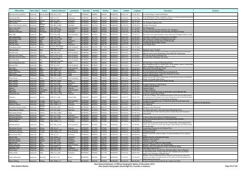
Official Name Name Status Feature Statutory Reference Land District Projection Northing Easting Datum Latitude Longitude Description Comment<br />
Maniototo Survey District Approved Survey District 1960 (61) p.1515 Otago NZTM2000 4995800 1367200 NZGD2000 45 09 10 S 170 02 18 E In Central Otago. Instead <strong>of</strong> Maniatoto<br />
Mannering Cliffs Approved Cliff 1966 (1) p.18 Canterbury NZTM2000 5223700 1515500 NZGD2000 43 08 05 S 171 57 40 E<br />
In the Waimakariri Gorge, opposite to where an unnamed stream flowing from<br />
Lake Blackwater enters the Waimakariri River<br />
Mannering Stream Approved Stream 1968 (9) p.268 Canterbury NZTM2000 5226100 1523400 NZGD2000 43 06 50 S 172 03 31 E<br />
Manning Bay Approved Bay 1941 (HON) p.17 Southland NZTM2000 4790800 1232500 NZGD2000 46 56 04 S 168 10 18 E On The Neck, Paterson Inlet.<br />
Manor Park Railway Station Approved<br />
Railway<br />
Station<br />
1954 (80) p.2088 Wellington NZTM2000 5441700 1766000 NZGD2000 41 09 33 S 174 58 43 E Instead <strong>of</strong> Haywards<br />
Man-o-war Creek Approved Stream 1943 (HON) p.17 North Auckland NZTM2000 6093300 1709600 NZGD2000 35 17 51 S 174 12 20 E Not "Manawaora"<br />
Manson Creek Approved Stream 1964 (79) p.2365 Canterbury NZTM2000 5224100 1498400 NZGD2000 43 07 44 S 171 45 03 E Flows south-east from Mount Manson into Craigieburn<br />
Mansons Peninsula Approved Peninsula 1978 (13) p.422 Canterbury NZTM2000 5168200 1572200 NZGD2000 43 38 19 S 172 39 19 E For the peninsula between Governors Bay and Head <strong>of</strong> the Bay<br />
Manu Bay Approved Bay 1973 (15) p.365 South Auckland NZTM2000 5812200 1759900 NZGD2000 37 49 25 S 174 49 01 E Bay at the coast approximately 2 miles south-west <strong>of</strong> Raglan Harbour mouth<br />
Manuhakapakapa Approved Locality 1983 (18) p.409 Nelson NZTM2000 5471700 1665300 NZGD2000 40 54 12 S 173 46 31 E Correction <strong>of</strong> spelling from that as shown on NZMS1<br />
Manuherikia Valley Approved Valley 1990 (132) p.2739 Otago NZTM2000 5001700 1333000 NZGD2000 45 05 16 S 169 36 26 E Main valley from Omakau to St Bathans loop road<br />
Manuka Bay Approved Bay 1978 (13) p.422 Canterbury NZTM2000 5167700 1596000 NZGD2000 43 38 37 S 172 57 01 E For bay between Scrubby Bay and Menzies Bay<br />
Manuka Flat Approved Flat 1981 (58) p.1326 Nelson NZTM2000 5371300 1523000 NZGD2000 41 48 23 S 172 04 23 E The flat area above Dublin Terrace<br />
Manuka Island Approved Island 1974 (11) p.233 Canterbury NZTM2000 5273500 1583100 NZGD2000 42 41 27 S 172 47 37 E In the Waiau River<br />
Manukapua Island Approved Island<br />
Te Uri o Hau Claims<br />
Settlement Act 2002<br />
North Auckland NZTM2000 5972700 1711500 NZGD2000 36 23 04 S 174 14 35 E<br />
Manukau Bluff Approved Bluff 1990 (53) p.1213 Canterbury NZTM2000 5253500 1625300 NZGD2000 42 52 14 S 173 18 35 E Replaces name 'The Bluff'<br />
Manukau City Approved City 1966 (19) p.577 North Auckland NZTM2000 5903800 1767200 NZGD2000 36 59 50 S 174 52 44 E<br />
<strong>New</strong> city in North Auckland Land District comprising the area <strong>of</strong> the former<br />
districts <strong>of</strong> the County <strong>of</strong> Manukau and the Borough <strong>of</strong> Manurewa<br />
Manukau City Centre Approved Suburb 1979 (112) p.3715 North Auckland NZTM2000 5904400 1767400 NZGD2000 36 59 30 S 174 52 52 E For new city centre in Manukau City<br />
Manukau City Post Office Approved Post Office 1979 (112) p.3715 North Auckland NZTM2000 5904500 1767400 NZGD2000 36 59 27 S 174 52 52 E For post <strong>of</strong>fice in Manukau City centre<br />
Manupīrua Bay Approved Bay<br />
Te Arawa Lakes<br />
Settlement Act 2006<br />
South Auckland NZTM2000 5784500 1897000 NZGD2000 38 02 19 S 176 23 03 E<br />
Manuwhakapakapa Bay Approved Bay 1949 (22) p.858 Nelson NZTM2000 5472200 1665900 NZGD2000 40 53 55 S 173 46 57 E D'Urville Island. Instead <strong>of</strong> Manawakupakupa<br />
Maomao Bay Approved Bay 1967 (4) p.120 North Auckland NZTM2000 6076000 1757100 NZGD2000 35 26 49 S 174 43 52 E<br />
Bay immediately south <strong>of</strong> Te Paki Point, on the western coast <strong>of</strong> Tawhiti Rahi<br />
Island. Instead <strong>of</strong> "Moumou Bay", shown on maps<br />
Maori Bay Approved Bay 1988 (206) p.5173 North Auckland NZTM2000 5922200 1726500 NZGD2000 36 50 15 S 174 25 07 E Bay south <strong>of</strong> Muriwai Beach locality<br />
Maori Beach Approved Beach 1941 (HON) p.17 Southland NZTM2000 4799100 1225200 NZGD2000 46 51 21 S 168 04 58 E At the south end <strong>of</strong> Port William<br />
Maori Chief Peak Approved Peak 1975 (62) p.1632 Marlborough NZTM2000 5287100 1629500 NZGD2000 42 34 05 S 173 21 34 E For peak between the Conway River and Peaked Hill<br />
Maori Point Approved Point 1987 (62) p.1964 Otago NZTM2000 5022500 1258400 NZGD2000 44 52 08 S 168 40 32 E Point on Shotover River. Correction <strong>of</strong> position for name<br />
Maori Point Saddle Approved Saddle 1986 (89) p.2487 Otago NZTM2000 5023100 1259100 NZGD2000 44 51 50 S 168 41 06 E Saddle south <strong>of</strong> Skippers (loc)<br />
Maori Rocks Approved Rock 1988 (141) p.3245 North Auckland NZTM2000 6022580 1794920 NZGD2000 35 55 18 S 175 09 38 E<br />
Group <strong>of</strong> rocks NE Fanal Is (Motohinau Is) (Sometimes known as Cathedral<br />
Rocks. The Candle, Maori Rock)<br />
Maori Saddle Approved Saddle 1982 (76) p.2163 Otago NZTM2000 5110200 1291900 NZGD2000 44 05 47 S 169 09 03 E Correct position <strong>of</strong> name as per historic records<br />
Maori Stream Approved Stream 1974 (11) p.233 Canterbury NZTM2000 5217000 1542100 NZGD2000 43 11 51 S 172 17 14 E<br />
Maori Stream Approved Stream 1972 (18) p.379 Nelson NZTM2000 5363700 1569600 NZGD2000 41 52 41 S 172 38 01 E A western tributary <strong>of</strong> Lake Rotoroa<br />
Maori Stream Approved Stream 1989 (120) p.3005 North Auckland NZTM2000 5908000 1737400 NZGD2000 36 57 51 S 174 32 36 E Tributary <strong>of</strong> Huia Stream<br />
Mapere Approved Point 1951 (82) p.1607 Gisborne NZTM2000 5691400 2027400 NZGD2000 38 49 21 S 177 55 20 E Instead <strong>of</strong> Mapiri<br />
Mapouriki Approved Trig Station 1951 (82) p.1607 South Auckland NZTM2000 5710400 1932300 NZGD2000 38 41 33 S 176 49 14 E Instead <strong>of</strong> Maporiki<br />
Mapoutahi Approved Isthmus 1987 (62) p.1964 Otago NZTM2000 4932600 1414500 NZGD2000 45 44 07 S 170 36 56 E An isthmus sometimes known as Goat Island, east <strong>of</strong> Blueskin Bay<br />
Maraehako Bay Approved Bay 1990 (132) p.2739 Gisborne NZTM2000 5819700 2023500 NZGD2000 37 40 20 S 177 48 03 E Small bay, western Bay <strong>of</strong> Plenty<br />
In the City <strong>of</strong> Napier. The southernmost portion <strong>of</strong> the city bounded towards<br />
Maraenui Approved Suburb 1956 (17) p.406 Hawke's Bay NZTM2000 5618700 1935700 NZGD2000 39 30 57 S 176 54 17 E the east by the old Tutaekuri river-bed, towards the west by Riverbend Road,<br />
and towards the north by the area known as Marewa<br />
Maraeroa Approved Locality 2007 (4) p.120 North Auckland NZTM2000 5989700 1784800 NZGD2000 36 13 12 S 175 03 22 E Locality (not populated) near Te Titoki Point along the south-west coast<br />
Maraerohutu Approved Locality 1941 (HON) p.17 Gisborne NZTM2000 5784400 1972000 NZGD2000 38 00 42 S 177 14 12 E Not "Marairowatu" Position to be determined<br />
Maraerua Stream Approved Stream 1930 (HON) p.17 Southland NZTM2000 4867900 1279300 NZGD2000 46 16 00 S 168 50 17 E Not "Marairoa"<br />
Maraetaha Railway Station Approved<br />
Railway<br />
Station<br />
1949 (22) p.858 Gisborne NZTM2000 5690700 2024700 NZGD2000 38 49 48 S 177 53 30 E Replaces name Wharerata<br />
Maraetakaroro Stream Approved Stream 1973 (15) p.365 Wellington NZTM2000 5473000 1759400 NZGD2000 40 52 43 S 174 53 31 E For stream with outlet 1 mile north-west <strong>of</strong> Wharekohu Point<br />
Maraeweka Stream Approved Stream 1954 (80) p.2088 Otago NZTM2000 4997900 1422500 NZGD2000 45 09 00 S 170 44 31 E<br />
Joins Serpentine Creek near the junction <strong>of</strong> Carey Road and Serpentine<br />
Creek Road<br />
Maragouri Stream Approved Stream 1974 (11) p.233 Canterbury NZTM2000 5156700 1443500 NZGD2000 43 43 34 S 171 03 25 E<br />
Maramaratotara Bay Approved Bay 1951 (82) p.1607 South Auckland NZTM2000 5920400 1842900 NZGD2000 36 49 52 S 175 43 25 E In Mercury Bay near entrance to Whitianga Harbour<br />
Marangai Stream Approved Stream 1970 (10) p.297 Wellington NZTM2000 5468800 1852600 NZGD2000 40 53 35 S 175 59 54 E Flows south-east from Bute Trig. To join Mangapakeha Stream<br />
Mararua Bush Approved Forest 1930 (HON) p.17 Southland NZTM2000 4863700 1273800 NZGD2000 46 18 06 S 168 45 51 E Not Maoririra<br />
Group <strong>of</strong> three exposed shoals south <strong>of</strong> Tasman Bay, Manawatāwhi/Great<br />
Maratea Shoals Approved Shoal 2007 (58) p.1514 North Auckland NZTM2000 6219000 1521600 NZGD2000 34 10 01 S 172 08 58 E Island. Not named on current map. Dragon Teeth Shoals (not <strong>of</strong>ficial) shown<br />
on current chart<br />
Marawaiwai Stream Approved Stream 1988 (2) p.31 Gisborne NZTM2000 5777500 1975400 NZGD2000 38 04 21 S 177 16 44 E Large stream flowing into the Waioeka River<br />
Marawhara Stream Approved Stream 1988 (206) p.5173 North Auckland NZTM2000 5910200 1730500 NZGD2000 36 56 43 S 174 27 56 E Stream north <strong>of</strong> Piha<br />
Marawhiupungarehu Approved Locality 1932 (HON) p.17 North Auckland NZTM2000 5924100 1773700 NZGD2000 36 48 47 S 174 56 50 E On Motuihe Island<br />
Marcaciones Point Approved Point 1988 (2) p.31 Southland NZTM2000 4965400 1125500 NZGD2000 45 18 15 S 166 56 50 E<br />
Eastern most point <strong>of</strong> Bauza Island. Currently identified as Flurry Head on<br />
maps<br />
Marcel Pass Approved Pass 1929 (HON) p.17 Canterbury NZTM2000 5173000 1371800 NZGD2000 43 33 40 S 170 10 28 E Between Mounts Lendenfeld and Haast<br />
Marchant Glacier Approved Glacier 1949 (22) p.858 Westland NZTM2000 5167300 1358700 NZGD2000 43 36 29 S 170 00 36 E Replaces name Copland<br />
Marchlaw Stream Approved Stream 1970 (10) p.297 Canterbury NZTM2000 5258500 1623000 NZGD2000 42 49 33 S 173 16 53 E Tributary <strong>of</strong> Jed River<br />
Marconi Hill Approved Hill 1981 (58) p.1326 Westland NZTM2000 5318500 1464700 NZGD2000 42 16 26 S 171 21 33 E Hill to be used for location <strong>of</strong> radio repeater<br />
Mares Leg Cove Approved Cove 1974 (11) p.233 South Auckland NZTM2000 5920300 1848900 NZGD2000 36 49 50 S 175 47 27 E Between "Cathedral Cove" and "Stingray Bay"<br />
Margaret Glacier Approved Glacier 1938 (HON) p.17 Otago NZTM2000 5061900 1231300 NZGD2000 44 30 07 S 168 21 43 E Between Hedin and Stefansson Peaks, Dart Barrier Range<br />
Margarets Tarn Approved Lake 1964 (79) p.2365 Canterbury NZTM2000 5247500 1481800 NZGD2000 42 54 57 S 171 33 07 E Fifty chains north <strong>of</strong> Trig. J<br />
Maria Island Approved Island 1958 (73) p.1731 North Auckland NZTM2000 5935500 1779100 NZGD2000 36 42 34 S 175 00 19 E In the Noises Group, Hauraki Gulf. Alternative Māori name is Ruapuke<br />
Marian Peak Approved Peak 1956 (17) p.406 Southland NZTM2000 5030200 1211700 NZGD2000 44 46 34 S 168 05 33 E<br />
In Darran Mountains on ridge between Lake Adelaide and Lake Marian<br />
Basins. One mile west <strong>of</strong> Adelaide Peak<br />
Between Owen and Maunga Survey Districts and forming the watershed<br />
Marino Mountains Approved Mountain 1957 (6) p.118 Nelson NZTM2000 5401900 1556900 NZGD2000 41 32 00 S 172 29 00 E between the Matiri and Owen Rivers to the south and the Wangapeka and<br />
Rolling Rivers to the north<br />
Marion Plateau Approved Plateau 1945 (HON) p.17 Otago NZTM2000 5065700 1240000 NZGD2000 44 28 20 S 168 28 26 E A large snowfield between Mounts Ian, Victoria, and Tiber<br />
<strong>New</strong> <strong>Zealand</strong> <strong>Names</strong><br />
<strong>New</strong> <strong>Zealand</strong> <strong>Gazetteer</strong> <strong>of</strong> Official Geographic <strong>Names</strong> (8 <strong>November</strong> <strong>2011</strong>)<br />
<strong>New</strong> <strong>Zealand</strong> Geographic Board Ngā Pou Taunaha o Aotearoa Page 53 <strong>of</strong> 120


