Gazetteer of New Zealand Names - 3 November 2011
Gazetteer of New Zealand Names - 3 November 2011
Gazetteer of New Zealand Names - 3 November 2011
Create successful ePaper yourself
Turn your PDF publications into a flip-book with our unique Google optimized e-Paper software.
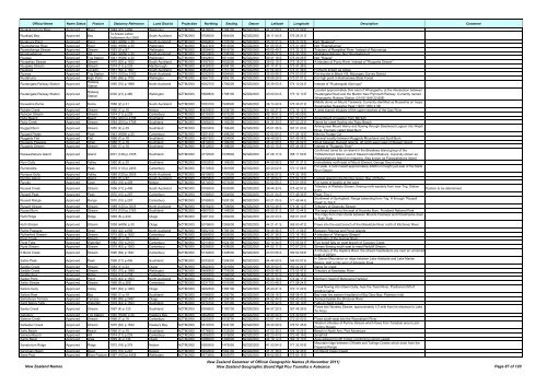
Official Name Name Status Feature Statutory Reference Land District Projection Northing Easting Datum Latitude Longitude Description Comment<br />
Ruakokoputuna River Approved River 1949 (22) p.858 Wellington NZTM2000 5416000 1798100 NZGD2000 41 22 59 S 175 22 09 E<br />
Ruakōpū Bay Approved Bay<br />
Te Arawa Lakes<br />
Settlement Act 2006<br />
South Auckland NZTM2000 5768000 1904400 NZGD2000 38 11 04 S 176 28 31 E<br />
Ruakoura Point Approved Point 1943 (HON) p.30 North Auckland NZTM2000 6084800 1723200 NZGD2000 35 22 21 S 174 21 22 E Not "Ruakora"<br />
Ruamahanga River Approved River 1930 (HON) p.30 Wellington NZTM2000 5447200 1812500 NZGD2000 41 05 55 S 175 31 49 E Not "Ruamahunga"<br />
Ruamahanga Stream Approved Stream 1953 (3) p.87 Wellington NZTM2000 5558400 1816700 NZGD2000 40 05 49 S 175 32 32 E Tributary <strong>of</strong> Rangitikei River. Instead <strong>of</strong> Raumanga<br />
Ruaotuwhenua Approved Hill 1940 (HON) p.30 North Auckland NZTM2000 5912400 1738300 NZGD2000 36 55 27 S 174 33 10 E Waitakere Ranges. Not "Ruotewhenua"<br />
Ruapae Approved Trig Station 1941 (HON) p.30 Wellington NZTM2000 5492800 1811400 NZGD2000 40 41 19 S 175 30 06 E Not "Ruapai"<br />
Ruapahau Stream Approved Stream 1975 (62) p.1632 South Auckland NZTM2000 5787500 1802500 NZGD2000 38 02 15 S 175 18 27 E A tributary <strong>of</strong> Puniu River. Instead <strong>of</strong> "Ruapaha Stream"<br />
Ruapake Stream Approved Stream 1974 (11) p.233 Marlborough NZTM2000 5428300 1658100 NZGD2000 41 17 41 S 173 41 38 E<br />
Ruapuke Approved Locality 1951 (82) p.1607 South Auckland NZTM2000 5802400 1757700 NZGD2000 37 54 44 S 174 47 38 E Formerly known as Aotea<br />
Ruaroa Approved Trig Station 1974 (100) p.2163 North Auckland NZTM2000 6032300 1694900 NZGD2000 35 50 56 S 174 03 03 E For trig site in Block VIII, Maungaru Survey District<br />
Ruatahuna Approved High Point 1980 (66) p.1752 Wellington NZTM2000 5667100 1855100 NZGD2000 39 06 29 S 175 57 01 E For high point in Kaimanawa State Forest<br />
Ruatangata Railway Station Approved<br />
Railway<br />
Station<br />
1950 (70) p.1989 North Auckland NZTM2000 6052700 1706200 NZGD2000 35 39 50 S 174 10 24 E Instead <strong>of</strong> "Ruatangata (Springs)"<br />
Ruatangata Railway Station Approved<br />
Railway<br />
Station<br />
2000 (21) p.480 Wellington NZTM2000 5569800 1788100 NZGD2000 40 00 04 S 175 12 13 E<br />
Located approximately 3km east <strong>of</strong> Whangaehu, at the intersection between<br />
Ruatangata Road and the Marton <strong>New</strong> Plymouth Railway. Currently named<br />
Whangaehu Railway Station (31/03/1949 22:858)<br />
Ruawahia Dome Approved Dome 1988 (2) p.31 South Auckland NZTM2000 5763100 1906900 NZGD2000 38 13 40 S 176 30 21 E<br />
Middle dome on Mount Tarawera. Currently identified as Ruawahia on maps.<br />
Supersedes Ruawahia Peak (19/01/1950 4:39)<br />
Rubble Creek Approved Stream 1966 (1) p.18 Nelson NZTM2000 5450900 1538700 NZGD2000 41 05 27 S 172 16 12 E A west branch tributary <strong>of</strong> the upper reaches <strong>of</strong> the Ugly River<br />
Rubicon Stream Approved Stream 1974 (11) p.233 Canterbury NZTM2000 5315300 1573200 NZGD2000 42 18 51 S 172 40 29 E<br />
Ruby Beach Approved Beach 1984 (204) p.4798 Southland NZTM2000 5068200 1193200 NZGD2000 44 25 30 S 167 53 22 E Amendment <strong>of</strong> position from 867424<br />
Ruby Creek Approved Stream 1984 (204) p.4798 Southland NZTM2000 5068200 1193200 NZGD2000 44 25 30 S 167 53 22 E Name for creek flowing into Ruby Beach<br />
Rugged Burn Approved Stream 1950 (4) p.39 Southland NZTM2000 5000400 1168400 NZGD2000 45 01 06 S 167 31 20 E<br />
Arising near Mount Henry and flowing through Deadwood Lagoon into Wapiti<br />
River. Formerly called West Burn<br />
Rugged Peaks Approved Peak 1943 (HON) p.30 Canterbury NZTM2000 5251400 1498200 NZGD2000 42 52 60 S 171 45 12 E Next to Trudge Col<br />
Ruggedy Flat Approved Flat 1966 (1) p.18 Southland NZTM2000 4801900 1204800 NZGD2000 46 49 08 S 167 49 08 E General locality between Ruggedy Mountains and Scott Burn<br />
Ruggedy Passage Approved Strait 1966 (1) p.18 Southland NZTM2000 4814000 1196200 NZGD2000 46 42 20 S 167 43 02 E Strait between Rugged Islands, <strong>of</strong>f north-west coast <strong>of</strong> Stewart Island<br />
Ruggedy Stream Approved Stream 1966 (1) p.18 Southland NZTM2000 4812600 1198500 NZGD2000 46 43 10 S 167 44 45 E Instead <strong>of</strong> "Ruggedy River"<br />
Confirmed name for an island in the Breaksea Island group <strong>of</strong> the<br />
Rukawahakura Island Approved Island 2001 (149) p.3705 Southland NZTM2000 4772000 1235800 NZGD2000 47 06 17 S 168 11 59 E Titi/Muttonbird Island, east <strong>of</strong> Stewart Island/Rakiura. Currently shown as<br />
Rukawahakura Island on mapping. Also known as Pukawahakura Island<br />
Rum Gully Approved Valley 1950 (4) p.39 Southland NZTM2000 5002500 1168500 NZGD2000 44 59 58 S 167 31 31 E Immediately north-east <strong>of</strong> Mount Elwood, George Sound area<br />
Rumdoodle Approved Peak 1976 (110) p.2453 Canterbury NZTM2000 5174500 1381800 NZGD2000 43 33 02 S 170 17 56 E<br />
For peak, a rock massif approximately 2440m in height just east <strong>of</strong> the Malte<br />
Brun Glacier<br />
Rumpus Gully Approved Valley 1989 (120) p.3005 North Auckland NZTM2000 5910600 1737000 NZGD2000 36 56 27 S 174 32 19 E<br />
Rurima Island Approved Island 1953 (3) p.87 South Auckland NZTM2000 5805800 1940800 NZGD2000 37 49 54 S 176 52 20 E Largest island in the Rurima Group, Bay <strong>of</strong> Plenty<br />
Ruruku Approved Cave 1983 (18) p.409 Nelson NZTM2000 5474000 1673000 NZGD2000 40 52 55 S 173 51 59 E For name <strong>of</strong> locality at the cave<br />
Russek Creek Approved Stream 1956 (17) p.406 South Auckland NZTM2000 5708300 1835900 NZGD2000 38 44 33 S 175 42 51 E<br />
Tributary <strong>of</strong> Waikato Stream, flowing north-easterly from near Trig. Station<br />
2101<br />
Russell Peak Approved Peak 1970 (10) p.297 Canterbury NZTM2000 5198900 1504900 NZGD2000 43 21 24 S 171 49 35 E Peak, Trig. I<br />
Russell Range Approved Range 1970 (10) p.297 Canterbury NZTM2000 5199500 1505100 NZGD2000 43 21 05 S 171 49 44 E<br />
Southwest <strong>of</strong> Springfield. Range extending from Trig. H through "Russell<br />
Peak" to Trig F<br />
Russell Stream Approved Stream 1989 (120) p.3005 North Auckland NZTM2000 5915400 1739900 NZGD2000 36 53 49 S 174 34 13 E Tributary <strong>of</strong> Opanuku Stream<br />
Russet Burn Approved Stream 1974 (100) p.2163 Southland NZTM2000 4907000 1148000 NZGD2000 45 50 31 S 167 10 44 E The large stream to the east <strong>of</strong> Hauroko Burn, Fiordland National Park<br />
Ruth Ridge Approved Ridge 1969 (8) p.240 Otago NZTM2000 5081700 1269200 NZGD2000 44 20 33 S 168 51 00 E<br />
The ridge from main divide between Mounts Fastness and Pickelhaube down<br />
to Ruth Flats<br />
Ruth Stream Approved Stream 1938 (HON) p.30 Otago NZTM2000 5079600 1269000 NZGD2000 44 21 41 S 168 50 47 E Flows into the east branch <strong>of</strong> the Matukituki River north <strong>of</strong> Kitchener River<br />
Ruthe Passage Approved Strait 1949 (22) p.858 North Auckland NZTM2000 5922100 1796100 NZGD2000 36 49 36 S 175 11 56 E Between Rotorua and Ponui Islands<br />
Rutherford Stream Approved Stream 1975 (62) p.1632 Canterbury NZTM2000 5280600 1625000 NZGD2000 42 37 36 S 173 18 18 E A tributary <strong>of</strong> "Waingaro Stream"<br />
Ryan Creek Approved Stream 1966 (1) p.18 Nelson NZTM2000 5466600 1531900 NZGD2000 40 56 56 S 172 11 27 E A tributary <strong>of</strong> the Gunner River<br />
Ryde Falls Approved Waterfall 1982 (76) p.2163 Canterbury NZTM2000 5211800 1524100 NZGD2000 43 14 34 S 172 03 54 E Five tiered falls on west branch <strong>of</strong> Coopers Creek<br />
Ryde Stream Approved Stream 1979 (42) p.1553 Canterbury NZTM2000 5029500 1438500 NZGD2000 44 52 11 S 170 57 20 E Stream flowing south east to meet Redcliff Stream<br />
S Bend Creek Approved Stream 1995 (69) p.1847 Canterbury NZTM2000 5134600 1348500 NZGD2000 43 53 56 S 169 52 06 E<br />
A tributary <strong>of</strong> the Hopkins River, the stream headwaters are near an unnamed<br />
peak <strong>of</strong> 2252m<br />
Sabre Peak Approved Peak 1956 (17) p.406 Southland NZTM2000 5033200 1208300 NZGD2000 44 44 50 S 168 03 07 E<br />
In Darran Mountains on ridge between Lake Adelaide and Lake Marian<br />
Basins. Half a mile west <strong>of</strong> Adelaide Peak<br />
Saddle Creek Approved Stream 1984 (1) p.24 Otago NZTM2000 4842400 1321800 NZGD2000 46 30 52 S 169 22 24 E Name for creek<br />
Saddle Creek Approved Stream 1950 (70) p.1989 Wellington NZTM2000 5466900 1776500 NZGD2000 40 55 48 S 175 05 47 E Tributary <strong>of</strong> Kawhatau River<br />
Saddle Spur Approved Ridge 1974 (11) p.233 Canterbury NZTM2000 5309700 1566000 NZGD2000 42 21 51 S 172 35 14 E<br />
Sadler Point Approved Point 1979 (42) p.1553 North Auckland NZTM2000 5958600 1755500 NZGD2000 36 30 19 S 174 44 11 E Northern Head <strong>of</strong> Mahurangi Harbour<br />
Sailor Stream Approved Stream 1968 (9) p.268 Canterbury NZTM2000 5231700 1516400 NZGD2000 43 03 46 S 171 58 24 E<br />
Sailors Gully Approved Valley 1987 (62) p.1964 Otago NZTM2000 4932600 1389100 NZGD2000 45 43 41 S 170 17 22 E<br />
Creek flowing into Green Gully, near the Taieri River. Positional shift <strong>of</strong><br />
existing name<br />
Sailors Rest Approved Bay 1966 (1) p.18 Southland NZTM2000 4786600 1230700 NZGD2000 46 58 16 S 168 08 41 E Bay near the eastern headland <strong>of</strong> Big Glory Bay, Paterson Inlet<br />
Sainsburys Terrace Approved Terrace 1986 (89) p.2487 Otago NZTM2000 5021400 1258700 NZGD2000 44 52 44 S 168 40 43 E Terrace beside the Shotover River<br />
Saint Marys Falls Approved Waterfall 1979 (42) p.1553 Southland NZTM2000 5010100 1191300 NZGD2000 44 56 42 S 167 49 10 E Falls on Saint Creek<br />
Saints Creek Approved Stream 1967 (4) p.120 Southland NZTM2000 5008600 1190700 NZGD2000 44 57 29 S 167 48 38 E<br />
Flows into Worsley Stream, approximately 1/2 mile from its entrance to Lake<br />
Te Anau<br />
Salisbury Approved Trig Station 1945 (HON) p.30 Hawke's Bay NZTM2000 5602600 1901400 NZGD2000 39 40 24 S 176 30 50 E<br />
Salmon Creek Approved Stream 1966 (1) p.18 Canterbury NZTM2000 5225300 1518700 NZGD2000 43 07 14 S 172 00 02 E Flows south-west into the Waimakariri River<br />
Saltwater Creek Approved Stream 1975 (62) p.1632 Hawke's Bay NZTM2000 5619700 1932100 NZGD2000 39 30 29 S 176 51 45 E<br />
Western tributary <strong>of</strong> Purimu Stream which flows from Taradale area to join<br />
Purimu Stream<br />
Salty Beach Approved Beach 1966 (1) p.18 Southland NZTM2000 4776900 1233500 NZGD2000 47 03 35 S 168 10 25 E Beach in North Arm, Port Adventure<br />
Samoa Mound Approved Hill 1974 (11) p.233 Canterbury NZTM2000 5306300 1579800 NZGD2000 42 23 43 S 172 45 16 E Small hill<br />
Sams Basin Approved Area 1999 (4) p.134 Otago NZTM2000 5086000 1306500 NZGD2000 44 19 12 S 169 19 10 E Area adjacent to Mt Triplet. Confirming current usage<br />
Sanatorium Ridge Approved Ridge 1972 (18) p.379 Nelson NZTM2000 5360500 1479500 NZGD2000 41 53 54 S 171 32 50 E<br />
Mountain ridge between O'Keefe and Tailings Creeks which drain from the<br />
Paparoa Range<br />
Sanctuary Basin Approved Basin 1970 (10) p.297 Nelson NZTM2000 5402600 1562100 NZGD2000 41 31 38 S 172 32 45 E On Mount Owen massif<br />
Sand Pool Approved River Feature 1987 (163) p.4458 Wellington NZTM2000 5673900 1845570 NZGD2000 39 02 58 S 175 50 16 E<br />
<strong>New</strong> <strong>Zealand</strong> <strong>Names</strong><br />
Position to be determined<br />
<strong>New</strong> <strong>Zealand</strong> <strong>Gazetteer</strong> <strong>of</strong> Official Geographic <strong>Names</strong> (8 <strong>November</strong> <strong>2011</strong>)<br />
<strong>New</strong> <strong>Zealand</strong> Geographic Board Ngā Pou Taunaha o Aotearoa Page 87 <strong>of</strong> 120


