Gazetteer of New Zealand Names - 3 November 2011
Gazetteer of New Zealand Names - 3 November 2011
Gazetteer of New Zealand Names - 3 November 2011
Create successful ePaper yourself
Turn your PDF publications into a flip-book with our unique Google optimized e-Paper software.
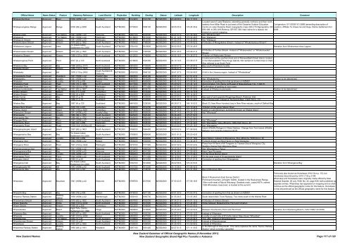
Official Name Name Status Feature Statutory Reference Land District Projection Northing Easting Datum Latitude Longitude Description Comment<br />
Whakapohai River Approved River 1939 (HON) p.42 Westland NZTM2000 5143400 1301700 NZGD2000 43 48 08 S 169 17 30 E<br />
Located west <strong>of</strong> Lake Ōkataina, extending generally northerly and then northeasterly<br />
from Millar Road to just west <strong>of</strong> the Okataina Outdoor Education Corrigendum: 5/11/2009 161:3889 (amending description <strong>of</strong><br />
Whakapoungakau Range Approved Range 2009 (99) p.2258 South Auckland NZTM2000 5779300 1899100 NZGD2000 38 05 05 S 176 24 35 E Centre on Lake Okataina Road, topographic maps 260-U15-Ngongotaha, GR location). Affiliate Te Arawa Iwi and Hapu Claims Settlement Act<br />
092 408, to 260-U16-Rotorua, GR 057 329. <strong>New</strong> name for a feature not<br />
named on current mapping.<br />
2008<br />
Whakapunake Approved Trig Station 1941 (HON) p.42 Gisborne NZTM2000 5697100 2000500 NZGD2000 38 47 02 S 177 36 36 E Not "Whakapunaki"<br />
Whakapuni Approved Trig Station 1941 (HON) p.42 Wellington NZTM2000 5418900 1813000 NZGD2000 41 21 12 S 175 32 46 E Not "Wakapuni<br />
Whakapuni Stream Approved Stream 1941 (HON) p.42 Wellington NZTM2000 5416700 1812000 NZGD2000 41 22 24 S 175 32 06 E Not "Wakapuni<br />
Whakarautawa Stream Approved Stream 1975 (62) p.1632 South Auckland NZTM2000 5785600 1785500 NZGD2000 38 03 30 S 175 06 52 E A tributary <strong>of</strong> Mangakiekie Stream. Instead <strong>of</strong> "Whakaraukaua Stream"<br />
Whakarewa Lagoon Approved Lake<br />
Te Arawa Lakes<br />
Settlement Act 2006<br />
South Auckland NZTM2000 5784100 1915600 NZGD2000 38 02 09 S 176 35 45 E Alteration from Whaharewa-rewa Lagoon<br />
Whakariawaka Stream Approved Stream 1975 (62) p.1632 South Auckland NZTM2000 5777700 1787500 NZGD2000 38 07 45 S 175 08 21 E<br />
A tributary <strong>of</strong> Turitea Stream. Instead <strong>of</strong> "Whakarwaka" or "Whakariuwaka"<br />
Stream<br />
Whakarino Stream Approved Stream 1989 (120) p.3005 North Auckland NZTM2000 5912600 1746900 NZGD2000 36 55 16 S 174 38 57 E Tributary <strong>of</strong> Waikumete Stream<br />
Coastal point at the southernmost end <strong>of</strong> Manawatāwhi/Great Island, located<br />
Whakarongorua Point Approved Point 2007 (4) p.120 North Auckland NZTM2000 6218600 1520300 NZGD2000 34 10 14 S 172 08 07 E in the Manawatāwhi/Three Kings Islands. Not named on current map or chart.<br />
Also referred to as South Point<br />
Whakaruro Bay Approved Bay 1988 (206) p.5173 North Auckland NZTM2000 5904200 1730600 NZGD2000 36 59 57 S 174 28 04 E Bay south <strong>of</strong> Karekare locality<br />
Whakatai Stream Approved Stream 1989 (120) p.3005 North Auckland NZTM2000 5910700 1730600 NZGD2000 36 56 27 S 174 27 60 E<br />
Whakataka Approved Hill 1976 (110) p.2453<br />
South Auckland &<br />
Gisborne<br />
NZTM2000 5709100 1946100 NZGD2000 38 41 57 S 176 58 46 E A hill in the Urewera region. Instead <strong>of</strong> "Whakatakaa"<br />
Whakatakahe Head Approved Headland 1941 (HON) p.42 Hawke's Bay NZTM2000 5660500 2020100 NZGD2000 39 06 12 S 177 51 27 E<br />
Whakatarehu Approved Locality 1941 (HON) p.42 Hawke's Bay NZTM2000 5667900 1916200 NZGD2000 39 04 51 S 176 39 19 E Not "Whakaterehu" Position to be determined<br />
Whakatari Approved Locality 1983 (18) p.409 Nelson NZTM2000 5488200 1683800 NZGD2000 40 45 10 S 173 59 34 E Correction <strong>of</strong> spelling from that as shown on NZMS1<br />
Whakatere Peak Approved Peak 1950 (70) p.1989 North Auckland NZTM2000 6071600 1651700 NZGD2000 35 29 52 S 173 34 12 E Approximately 140 chains north-east <strong>of</strong> Ngapukehaua Trig. (1,620 ft)<br />
Whakatikei River Approved River 1984 (204) p.4798 Wellington NZTM2000 5446000 1771400 NZGD2000 41 07 09 S 175 02 30 E Confirmation <strong>of</strong> spelling <strong>of</strong> river name<br />
Whakaumuataneteko Approved Trig Station 1951 (82) p.1607 Gisborne NZTM2000 5682600 2006700 NZGD2000 38 54 41 S 177 41 23 E Instead <strong>of</strong> Whakaumuatanaako Position to be determined<br />
Whalan Stream Approved Stream 1974 (11) p.233 Canterbury NZTM2000 5060400 1379400 NZGD2000 44 34 33 S 170 13 17 E<br />
Whalan Stream Approved Stream 1968 (9) p.268 Canterbury NZTM2000 5062600 1380800 NZGD2000 44 33 24 S 170 14 24 E<br />
Whale Corner Approved Bay 1966 (1) p.18 Southland NZTM2000 4794400 1230600 NZGD2000 46 54 04 S 168 08 59 E Bay east <strong>of</strong> and opposite Ringaringa Beach, Paterson Inlet<br />
Whalers Base Approved Bay 1966 (1) p.18 Southland NZTM2000 4792500 1222800 NZGD2000 46 54 49 S 168 02 46 E Bay in Prices Inlet. Instead <strong>of</strong> "Surveyors Bay" (1941 Hon p. 31)<br />
Whalers Bay Approved Bay 1967 (4) p.120 Southland NZTM2000 4841600 1239300 NZGD2000 46 28 57 S 168 18 02 E Block 23, <strong>New</strong> River Hundred; bay in <strong>New</strong> River estuary, south <strong>of</strong> Daffodil Bay<br />
Whales Back Stream Approved Stream 1970 (10) p.297 Canterbury NZTM2000 5296000 1614700 NZGD2000 42 29 18 S 173 10 44 E Tributary <strong>of</strong> the upper Mason River<br />
Whanau Island Approved Island 1987 (196) p.5081 Canterbury NZTM2000 5073600 1378000 NZGD2000 44 27 25 S 170 12 34 E Island on Lake Benmore, sometimes known as 'Madak Island'<br />
Whanaukini Stream Approved Stream 1941 (HON) p.42 Hawke's Bay NZTM2000 5608700 1895000 NZGD2000 39 37 14 S 176 26 12 E Not "Whanauki"<br />
Whangaahei Approved Locality 1980 (66) p.1752 South Auckland NZTM2000 5945200 1820400 NZGD2000 36 36 48 S 175 27 52 E<br />
Whangaahei Bay Approved Bay 1980 (66) p.1752 South Auckland NZTM2000 5945200 1820400 NZGD2000 36 36 48 S 175 27 52 E<br />
Whangae River Approved River 1943 (HON) p.42 North Auckland NZTM2000 6089700 1699900 NZGD2000 35 19 51 S 174 05 57 E Not "Whanagai"<br />
Whangaehu River Approved River 1949 (22) p.858 Wellington NZTM2000 5460000 1828300 NZGD2000 40 58 45 S 175 42 49 E Not "Wangaehu" Also <strong>of</strong>ficial by 1939-1941 Hon p. 42<br />
Whangaehu Road Approved Road 1939-1941 (HON) p.42 Wellington NZTM2000 5600200 1807500 NZGD2000 39 43 22 S 175 25 16 E Not "Wangaehu"<br />
Whangakopikopiko Island Approved Island 1997 (60) p.1403 South Auckland NZTM2000 5786000 1964400 NZGD2000 38 00 02 S 177 08 59 E<br />
Island (Wildlife Refuge) in Ohiwa Harbour. Change from Tern Island (Wildlife<br />
Refuge) (not currently named on W15)<br />
Whangamarino Bay Approved Bay<br />
Te Arawa Lakes<br />
Settlement Act 2006<br />
South Auckland NZTM2000 5785800 1893600 NZGD2000 38 01 41 S 176 20 42 E<br />
Whangamoa Approved Locality 1949 (22) p.858 Nelson NZTM2000 5448100 1643800 NZGD2000 41 07 02 S 173 31 18 E Near Nelson. Instead <strong>of</strong> Wangamoa. Also <strong>of</strong>ficial by 1939 Hon p. 42<br />
Whanganui Inlet Approved Bay 1940 (HON) p.42 Nelson NZTM2000 5506400 1563900 NZGD2000 40 35 33 S 172 34 24 E Formerly known as West Haven or West Wanganui<br />
Whanganui River Approved River 1991 (153) p.3226 Wellington NZTM2000 5575700 1771400 NZGD2000 39 57 05 S 175 00 23 E<br />
Flows from W flank <strong>of</strong> Mt Tongariro to Tasman Sea at Wanganui City.<br />
Spelling change from Wanganui River<br />
Whanganuioparua Inlet Approved Bay 1941 (HON) p.42 Gisborne NZTM2000 5702600 1960500 NZGD2000 38 45 06 S 177 08 53 E Not "Whangania o Parua"<br />
Whangaparaoa Bay Approved Bay 1936 (HON) p.42 Gisborne NZTM2000 5829400 2041300 NZGD2000 37 34 36 S 177 59 46 E Near Cape Runaway<br />
Whangaparapara Approved Locality 1939 (HON) p.42 North Auckland NZTM2000 5986500 1815500 NZGD2000 36 14 33 S 175 23 54 E On the Great Barrier Island<br />
Whangapau Point Approved Point 1940 (HON) p.42 North Auckland NZTM2000 6102300 1711400 NZGD2000 35 12 58 S 174 13 26 E On the west coast <strong>of</strong> Oruapukapuka Island<br />
Whangara Island Approved Island 1984 (1) p.24 North Auckland NZTM2000 5984400 1812400 NZGD2000 36 15 43 S 175 21 51 E Correction <strong>of</strong> spelling from Whangarara<br />
Whangaroa Inlet Approved Bay<br />
Te Arawa Lakes<br />
Settlement Act 2006<br />
South Auckland NZTM2000 5782700 1912800 NZGD2000 38 02 58 S 176 33 53 E Alteration from Whangaroa Bay<br />
Whangatauatia Hill Approved Hill 1943 (HON) p.42 North Auckland NZTM2000 6107300 1613200 NZGD2000 35 10 38 S 173 08 42 E<br />
Whangaumu Bay Approved Bay 1970 (10) p.297 North Auckland NZTM2000 6055400 1738200 NZGD2000 35 38 08 S 174 31 35 E Bay in Ngunguru Bay<br />
Whanokao Approved Mountain 1941 (HON) p.42 Gisborne NZTM2000 5799700 2037500 NZGD2000 37 50 43 S 177 58 16 E<br />
Block X Raukumara East Survey District.<br />
Prominent mountain, at height 1428m, located in the Raukumara Range,<br />
10km north-west <strong>of</strong> Mount Hikurangi. Geodetic mark, coded A5TA, named<br />
1328 Whanokao, beaconed, is located at the summit.<br />
Previously also known as Honokawa (1941 Hon p. 10), but<br />
Honokawa discontinued by 2010 (115) p.3108:<br />
Whanokao and Honokawa were originally made <strong>of</strong>ficial by <strong>New</strong><br />
<strong>Zealand</strong> Gazette, 29 July 1948, No. 42, page 939, both published as<br />
separate entries. Whanokao has appeared on mapping and so shall<br />
continue as the <strong>of</strong>ficial geographic name for this feature. Honokawa<br />
is now discontinued as the <strong>of</strong>ficial geographic name for this feature.<br />
Wharairiki Bay Approved Bay 1983 (18) p.409 Nelson NZTM2000 5476000 1671100 NZGD2000 40 51 50 S 173 50 37 E Correction <strong>of</strong> spelling from that as shown on NZMS1<br />
Wharanui Railway Station Approved<br />
Railway<br />
Station<br />
1939 (HON) p.42 Marlborough NZTM2000 5358100 1690700 NZGD2000 41 55 26 S 174 05 38 E South Island Main Trunk Railway. Two miles south <strong>of</strong> the Waima River<br />
Wharawhara Stream Approved Stream 1975 (62) p.1632 South Auckland NZTM2000 5837800 1852000 NZGD2000 37 34 21 S 175 51 12 E A tributary <strong>of</strong> Uretara Stream<br />
Whare Ngarahu Approved Ridge 1994 (133) p.4349 North Auckland NZTM2000 6147000 1637800 NZGD2000 34 49 07 S 173 24 48 E Ridge between Matawherohia Point and Omahuri<br />
Whare Stream Approved Stream 1968 (9) p.268 Canterbury NZTM2000 5223300 1546800 NZGD2000 43 08 28 S 172 20 45 E<br />
Whareakeake Approved Beach<br />
Ngāi Tahu Claims<br />
Settlement Act 1998<br />
Otago NZTM2000 4929600 1418600 NZGD2000 45 45 48 S 170 40 02 E Between Purehurehu Point and Pilot Point Alteration from Murdering Beach (13/07/1989 120:3005)<br />
Whareana Bay Approved Bay 1953 (67) p.1920 North Auckland NZTM2000 6187300 1600300 NZGD2000 34 27 21 S 173 00 12 E Instead <strong>of</strong> Whareane<br />
Whareata Approved Locality 1987 (163) p.4458 Nelson NZTM2000 5480200 1677900 NZGD2000 40 49 32 S 173 55 26 E Locality on east side <strong>of</strong> D'Urville Island. Map shows "Wharatea"<br />
Wharekaunga Approved Trig Station 1953 (3) p.87 South Auckland NZTM2000 5739900 1892000 NZGD2000 38 26 29 S 176 20 44 E Trig. 28A. Instead <strong>of</strong> Wharekauanga<br />
Wharekaunga Stream Approved Stream 1953 (3) p.87 South Auckland NZTM2000 5740100 1901200 NZGD2000 38 26 12 S 176 27 03 E Instead <strong>of</strong> Wharekauanga<br />
Wharekawa Approved Locality 1953 (67) p.1920 North Auckland NZTM2000 6188300 1599900 NZGD2000 34 26 49 S 172 59 56 E Instead <strong>of</strong> Wharekau<br />
Wharemoa Railway Station Approved<br />
Railway<br />
Station<br />
1963 (48) p.1181 Westland NZTM2000 5297100 1451400 NZGD2000 42 27 51 S 171 11 33 E<br />
In the Borough <strong>of</strong> Greymouth. This name replaces the name "Karoro Railway<br />
Station" which is hereby cancelled<br />
<strong>New</strong> <strong>Zealand</strong> <strong>Names</strong><br />
<strong>New</strong> <strong>Zealand</strong> <strong>Gazetteer</strong> <strong>of</strong> Official Geographic <strong>Names</strong> (8 <strong>November</strong> <strong>2011</strong>)<br />
<strong>New</strong> <strong>Zealand</strong> Geographic Board Ngā Pou Taunaha o Aotearoa Page 117 <strong>of</strong> 120


