Gazetteer of New Zealand Names - 3 November 2011
Gazetteer of New Zealand Names - 3 November 2011
Gazetteer of New Zealand Names - 3 November 2011
You also want an ePaper? Increase the reach of your titles
YUMPU automatically turns print PDFs into web optimized ePapers that Google loves.
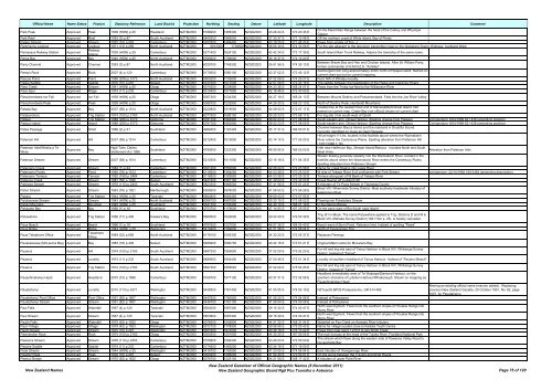
Official Name Name Status Feature Statutory Reference Land District Projection Northing Easting Datum Latitude Longitude Description Comment<br />
Park Peak Approved Peak 1938 (HON) p.25 Westland NZTM2000 5186900 1385200 NZGD2000 43 26 24 S 170 20 45 E<br />
On the Maximilian Range between the head <strong>of</strong> the Callery and Whymper<br />
Glacier<br />
Park Reef Approved Reef 1953 (3) p.87 South Auckland NZTM2000 5840300 1969500 NZGD2000 37 30 37 S 177 10 48 E Off the northern coast <strong>of</strong> White Island, Bay <strong>of</strong> Plenty<br />
Parker Stream Approved Stream 1970 (10) p.297 Canterbury NZTM2000 5202500 1499400 NZGD2000 43 19 25 S 171 45 33 E Flows from vicinity <strong>of</strong> Trig. J<br />
Parkinsons Lookout Approved Lookout 1971 (13) p.259 North Auckland NZTM2000 5912300 1739500 NZGD2000 36 55 30 S 174 33 58 E For the site adjacent to the television transmitter mast on the Waitakere Scenic Highway, Auckland West<br />
Parnassus Railway Station Approved<br />
Railway<br />
Station<br />
1939 (HON) p.25 Canterbury NZTM2000 5271400 1624100 NZGD2000 42 42 34 S 173 17 39 E South Island Main Trunk Railway. Adjoins the township <strong>of</strong> the same name.<br />
Paroa Bay Approved Bay 1940 (HON) p.25 North Auckland NZTM2000 6095600 1706600 NZGD2000 35 16 37 S 174 10 20 E<br />
Parry Channel Approved Channel 1953 (3) p.87 North Auckland NZTM2000 6029700 1749300 NZGD2000 35 51 56 S 174 39 13 E<br />
Between Bream Bay and Hen and Chicken Islands. After Sir William Parry,<br />
former commander <strong>of</strong> H.M.N.Z.S. "Achilles"<br />
Parson Rock Approved Rock 2007 (4) p.120 Canterbury NZTM2000 5170600 1580100 NZGD2000 43 37 02 S 172 45 12 E<br />
Submerged rock lying approximately 200m north <strong>of</strong> Ripapa Island. Named on<br />
current chart but not on current mapping<br />
Pascoe Point Approved Point 1988 (206) p.5173 North Auckland NZTM2000 5900200 1732600 NZGD2000 37 02 06 S 174 29 27 E Point NW <strong>of</strong> Whatipu locality<br />
Paske Saddle Approved Saddle 1970 (10) p.297 Nelson NZTM2000 5337000 1577000 NZGD2000 42 07 08 S 172 43 18 E The saddle between the headwaters <strong>of</strong> the Paske and Clarence Rivers<br />
Pass Creek Approved Stream 1941 (HON) p.25 Otago NZTM2000 5074200 1234900 NZGD2000 44 23 36 S 168 24 57 E Flows from the Trinity Ice-field to the Williamson River<br />
Pass Spur Approved Ridge 1974 (11) p.233 Canterbury NZTM2000 5315400 1577800 NZGD2000 42 18 48 S 172 43 50 E<br />
Passchendaele Ice Fall Approved Ice Fall 1938 (HON) p.25 Otago NZTM2000 5067300 1234300 NZGD2000 44 27 18 S 168 24 13 E Between Mounts Destiny and Passchendaele. Falls into the Joe River Valley<br />
Passchendaele Peak Approved Peak 1938 (HON) p.25 Otago NZTM2000 5068700 1232900 NZGD2000 44 26 30 S 168 23 13 E North <strong>of</strong> Destiny Peak, Humboldt Mountains<br />
Pataea Bay Approved Bay 2007 (58) p.1514 North Auckland NZTM2000 6220800 1519000 NZGD2000 34 09 02 S 172 07 17 E<br />
Coastal bay at the westernmost end <strong>of</strong> Manawatāwhi/Great Island. Not<br />
named on current map. Crater Bay (not <strong>of</strong>ficial) shown on current chart<br />
Patakorokoro Approved Trig Station 1974 (100) p.2163 North Auckland NZTM2000 6071900 1688100 NZGD2000 35 29 33 S 173 58 17 E For trig site 3 km south-west <strong>of</strong> Opahi<br />
Pataua Approved Trig Station 1988 (206) p.5173 Gisborne NZTM2000 5781700 1962900 NZGD2000 38 02 23 S 177 08 05 E South-eastern arm. Ohiwa Harbour (Spelling change from Patawa) Corrigendum: 6/04/1989 62:1438 (amending position)<br />
Pataua Island Approved Island 1988 (206) p.5173 Gisborne NZTM2000 5781700 1962900 NZGD2000 38 02 23 S 177 08 05 E South-eastern arm. Ohiwa Harbour (Spelling change from Patawa) Corrigendum: 6/04/1989 62:1438 (amending position)<br />
Patea Passage Approved Strait 1988 (2) p.31 Southland NZTM2000 4966400 1120400 NZGD2000 45 17 31 S 166 53 01 E<br />
Channel between Bauza Island and the mainland in Doubtful Sound.<br />
Currently identified on maps as Gaol Passage<br />
Hill at height 1113m, located in the foothills above where the Waimakariri<br />
Paterson Hill Approved Hill 2007 (58) p.1514 Canterbury NZTM2000 5212400 1512600 NZGD2000 43 14 10 S 171 55 25 E River enters the Canterbury Plains. Spelling alteration from Patterson Hill<br />
(13/01/1966 1:18)<br />
Paterson Inlet/Whaka a Te<br />
Wera<br />
Approved Bay<br />
Ngāi Tahu Claims<br />
Settlement Act 1998<br />
Southland NZTM2000 4790500 1223300 NZGD2000 46 55 55 S 168 03 03 E<br />
Inlet near Halfmoon Bay, Stewart Island/Rakiura. Includes North and South<br />
West Arms.<br />
Stream flowing generally easterly into the Waimakariri River, located in the<br />
Alteration from Paterson Inlet<br />
Paterson Stream Approved Stream 2007 (58) p.1514 Canterbury NZTM2000 5210300 1511500 NZGD2000 43 15 18 S 171 54 35 E foothills above where the Waimakariri River enters the Canterbury Plains.<br />
Spelling alteration from Patterson Stream<br />
Patersons Creek Approved Stream 1984 (1) p.24 Canterbury NZTM2000 5301200 1550600 NZGD2000 42 26 24 S 172 23 58 E Name for creek flowing into Lewis River<br />
Patersons Ponds Approved Pond 1992 (78) p.1513 Canterbury NZTM2000 5118500 1394200 NZGD2000 44 03 28 S 170 25 50 E W side <strong>of</strong> Tekapo River S <strong>of</strong> confluence with Fork Stream corrigendum: 22/10/1992 169:3464 (amending description)<br />
Patersons Terrace Approved Terrace 1992 (169) p.3464 Canterbury NZTM2000 5118500 1393800 NZGD2000 44 03 28 S 170 25 32 E Terrace along part <strong>of</strong> W Bank <strong>of</strong> Tekapo River<br />
Patience Creek Approved Stream 1981 (58) p.1326 Nelson NZTM2000 5407400 1561100 NZGD2000 41 29 03 S 172 32 03 E Creek flowing <strong>of</strong>f Culliford Hill<br />
Patirawa Stream Approved Stream 1976 (110) p.2453 South Auckland NZTM2000 5823300 1866500 NZGD2000 37 41 56 S 176 01 22 E A tributary <strong>of</strong> Te Puna Stream in Tauranga County<br />
Paton Stream Approved Stream 1963 (76) p.1921 Marlborough NZTM2000 5355600 1678000 NZGD2000 41 56 52 S 173 56 28 E<br />
Block VIII, Whernside Survey District. Most southerly headwater tributary <strong>of</strong><br />
Kekerengu River<br />
Patuha Approved Trig Station 1944 (HON) p.25 Taranaki NZTM2000 5664800 1683400 NZGD2000 39 09 43 S 173 57 55 E<br />
Patukauwae Stream Approved Stream 1943 (HON) p.25 North Auckland NZTM2000 6089100 1687900 NZGD2000 35 20 15 S 173 58 02 E Flowing into Puketotara Stream<br />
Patuki Mountain Approved Mountain 1945 (HON) p.25 Southland NZTM2000 5041700 1205400 NZGD2000 44 40 10 S 168 01 19 E In the Darran Range<br />
Patupahe Bay Approved Bay 1966 (1) p.18 Southland NZTM2000 4753700 1178600 NZGD2000 47 14 05 S 167 25 55 E On the east coast <strong>of</strong> Big South cape Island<br />
Patuwahine Approved Trig Station 1956 (17) p.406 Hawke's Bay NZTM2000 5668500 1932600 NZGD2000 39 04 09 S 176 50 39 E<br />
Trig. B1 in Block. The name Patuwahine applied to Trig. Stations D and M in<br />
Block VIII, Mohaka Survey District (1941 Hon p. 25), is hereby cancelled<br />
Paua Beach Approved Beach 1966 (1) p.18 Southland NZTM2000 4787600 1227000 NZGD2000 46 57 36 S 168 05 49 E Beach west <strong>of</strong> Burnt Point, Paterson Inlet. Instead <strong>of</strong> spelling "Pawa"<br />
Paua Ridge Approved Ridge 1944 (HON) p.25 Wellington NZTM2000 5419400 1764600 NZGD2000 41 21 36 S 174 58 04 E North <strong>of</strong> Tapokopoko Trig.<br />
Paua Telephone Office Approved<br />
Telephone<br />
Office<br />
1949 (22) p.858 North Auckland NZTM2000 6178100 1593300 NZGD2000 34 32 20 S 172 55 37 E Replaces Parenga<br />
Pauakaiwawe (McLarens Bay) Approved Bay 1983 (18) p.409 Nelson NZTM2000 5489900 1680700 NZGD2000 40 44 16 S 173 57 21 E Original Māori name for McLarens Bay<br />
Pauanui Approved Hill 1974 (100) p.2163 South Auckland NZTM2000 5897300 1855600 NZGD2000 37 02 09 S 175 52 25 E<br />
For hill and trig site east <strong>of</strong> Tairua Harbour in Block XIV, Whitianga Survey<br />
District. Instead <strong>of</strong> "Tairua"<br />
Pauanui Approved Locality 1974 (11) p.233 South Auckland NZTM2000 5899900 1854400 NZGD2000 37 00 46 S 175 51 34 E Locality at southern headland <strong>of</strong> Tairua Harbour. Instead <strong>of</strong> "Pauanui Beach"<br />
Pauanui Approved Trig Station 1974 (100) p.2163 South Auckland NZTM2000 5897300 1855600 NZGD2000 37 02 09 S 175 52 25 E<br />
Pauaohinekotau Head Approved Headland 2003 (73) p.1896 Canterbury NZTM2000 5169700 1577100 NZGD2000 43 37 31 S 172 42 58 E<br />
For hill and trig site east <strong>of</strong> Tairua Harbour in Block XIV, Whitianga Survey<br />
District. Instead <strong>of</strong> "Tairua"<br />
Headland immediately west <strong>of</strong> Te Waipapa/Diamond Harbour, on the<br />
southern shoreline <strong>of</strong> Lyttelton Harbour/Whakaraupō. Shown on mapping as<br />
Pauaohinekotau Head<br />
Pāuatahanui Approved Locality 2010 (173) p.4271 Wellington NZTM2000 5448500 1761400 NZGD2000 41 05 55 S 174 55 19 E NZTopo50 BP32-Paraparaumu, GR 614 485.<br />
Pauatahanui Post Office Approved Post Office 1951 (82) p.1607 Wellington NZTM2000 5447600 1760900 NZGD2000 41 06 25 S 174 54 58 E Instead <strong>of</strong> Pahautanui<br />
Pauatahanui Stream Approved Stream 1951 (82) p.1607 Wellington NZTM2000 5446700 1761100 NZGD2000 41 06 54 S 174 55 08 E Instead <strong>of</strong> Pahautanui<br />
Paul Falls Approved Waterfall 1967 (4) p.120 Taranaki NZTM2000 5654000 1687400 NZGD2000 39 15 32 S 174 00 47 E<br />
North west Egmont. Flows from the southern slopes <strong>of</strong> Pouakai Range into<br />
Stony River<br />
Paul Stream Approved Stream 1967 (4) p.120 Taranaki NZTM2000 5653800 1687400 NZGD2000 39 15 39 S 174 00 47 E<br />
North west Egmont. Flows from the southern slopes <strong>of</strong> Pouakai Range into<br />
Stony River<br />
Paulin Falls Approved Waterfall 1975 (62) p.1632 Otago NZTM2000 5078500 1242800 NZGD2000 44 21 32 S 168 31 04 E Waterfall on Fez Creek an Arawata River tributary<br />
Pauri Village Approved Village 1979 (42) p.1553 Wellington NZTM2000 5572100 1778900 NZGD2000 39 58 56 S 175 05 43 E Name for village located close to Kaitoke Youth Centre<br />
Pavitt Stream Approved Stream 1970 (10) p.297 Wellington NZTM2000 5481600 1872000 NZGD2000 40 46 18 S 176 13 22 E Flows from near point 1,275 ft to join Smith Creek<br />
Pawnbroker Rock Approved Rock 1974 (100) p.2163 Otago NZTM2000 5050300 1201900 NZGD2000 44 35 25 S 167 59 05 E The rock bivouac at the head <strong>of</strong> the Tutoko River, Fiordland National Park<br />
Pawsons Stream Approved Stream 1976 (110) p.2453 Canterbury NZTM2000 5155800 1594400 NZGD2000 43 45 03 S 172 55 50 E<br />
The stream which flows along the western side <strong>of</strong> Pawsons Valley Road to<br />
Duvauchelle Bay<br />
Peache Saddle Approved Saddle 1974 (11) p.233 Canterbury NZTM2000 5174400 1465200 NZGD2000 43 34 16 S 171 19 50 E<br />
Peak Stream Approved Stream 1944 (HON) p.25 Wellington NZTM2000 5416700 1762900 NZGD2000 41 23 05 S 174 56 54 E East tributary <strong>of</strong> Orongorongo River<br />
Peanter Peak Approved Peak 1970 (10) p.297 Nelson NZTM2000 5360400 1586200 NZGD2000 41 54 30 S 172 50 01 E On the spure between the Travers and Arnst Rivers<br />
Peanut Stream Approved Stream 1975 (62) p.1632 Otago NZTM2000 5076700 1225100 NZGD2000 44 21 58 S 168 17 42 E A tributary <strong>of</strong> upper Pyke River<br />
<strong>New</strong> <strong>Zealand</strong> <strong>Names</strong><br />
Altering an existing <strong>of</strong>ficial name (macron added). Replacing<br />
previous <strong>New</strong> <strong>Zealand</strong> Gazette, 25 October 1951, No. 82, page<br />
1607, for Pauatahanui.<br />
<strong>New</strong> <strong>Zealand</strong> <strong>Gazetteer</strong> <strong>of</strong> Official Geographic <strong>Names</strong> (8 <strong>November</strong> <strong>2011</strong>)<br />
<strong>New</strong> <strong>Zealand</strong> Geographic Board Ngā Pou Taunaha o Aotearoa Page 75 <strong>of</strong> 120


