

Gazetteer of New Zealand Names - 3 November 2011
Gazetteer of New Zealand Names - 3 November 2011
Gazetteer of New Zealand Names - 3 November 2011

You also want an ePaper? Increase the reach of your titles
YUMPU automatically turns print PDFs into web optimized ePapers that Google loves.
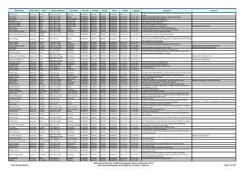
Official Name Name Status Feature Statutory Reference Land District Projection Northing Easting Datum Latitude Longitude Description Comment<br />
Arnott Creek Approved Stream 1964 (79) p.2365 Westland NZTM2000 5152200 1295400 NZGD2000 43 43 14 S 169 13 07 E<br />
Paringa-Haast Road. Flows into Tasman Sea 12 chains north-east <strong>of</strong> Grave<br />
Creek<br />
Arnst River Approved River 1960 (61) p.1515 Nelson NZTM2000 5360100 1587800 NZGD2000 41 54 39 S 172 51 10 E Nelson Lakes National Park. Shown on maps as Arnst Gully<br />
Aroaro Bay Approved Bay 1973 (15) p.365 South Auckland NZTM2000 5815000 1765000 NZGD2000 37 47 51 S 174 52 27 E Situated in Raglan Harbour at Raglan<br />
Aropaoanui Approved Locality 1951 (82) p.1607 Hawke's Bay NZTM2000 5645700 1941800 NZGD2000 39 16 14 S 176 57 42 E Instead <strong>of</strong> Arapawanui and Arapaoanui<br />
Aropaoanui Block Approved Block 1941 (HON) p.2 Hawke's Bay NZTM2000 5646200 1941800 NZGD2000 39 15 58 S 176 57 41 E Not Arapawanui and Arapaoanui<br />
Aropaoanui River Approved River 1951 (82) p.1607 Hawke's Bay NZTM2000 5645700 1943100 NZGD2000 39 16 13 S 176 58 36 E Instead <strong>of</strong> Arapawanui and Arapaoanui<br />
Aropaoanui Road Approved Road 1951 (82) p.1607 Hawke's Bay NZTM2000 5645000 1942200 NZGD2000 39 16 36 S 176 58 00 E Instead <strong>of</strong> Arapawanui and Arapaoanui Re-gazettal <strong>of</strong> 1941 Hon p. 2<br />
Arrow Face Approved Cliff 1986 (89) p.2487 Otago NZTM2000 5017800 1272100 NZGD2000 44 55 03 S 168 50 44 E Beside the Arrow River, just north <strong>of</strong> Arrowtown (loc)<br />
Artemis Peak Approved Peak 1954 (80) p.2088 Westland NZTM2000 5210100 1402400 NZGD2000 43 14 10 S 170 33 59 E On Willberg Range about one mile south <strong>of</strong> Avalon Peak<br />
Arthur Pass Post Office Approved Post Office 1951 (55) p.1019 Canterbury NZTM2000 5244100 1483000 NZGD2000 42 56 48 S 171 33 57 E Formerly known as Arthur's Pass Post Office<br />
Arthur Pass Railway Station Approved<br />
Railway<br />
Station<br />
1951 (55) p.1019 Canterbury NZTM2000 5244400 1482800 NZGD2000 42 56 38 S 171 33 48 E Formerly known as Arthur's Pass Railway Station<br />
Extending from Wangapeka Saddle in Tasman Survey District through Mount<br />
Arthur Range Approved Range 1950 (4) p.39 Nelson NZTM2000 5434400 1568600 NZGD2000 41 14 28 S 172 37 31 E Arthur to where the Richmond-Collingwood main highway crosses the Takaka<br />
Hills in Kaiteriteri Survey District<br />
Arthurs Creek Approved Stream 1986 (89) p.2487 Otago NZTM2000 5042800 1240300 NZGD2000 44 40 41 S 168 27 42 E Creek flowing into the Rees River<br />
Arthur's Pass Approved Pass 1957 (51) p.1332 Canterbury NZTM2000 5244700 1483300 NZGD2000 42 56 29 S 171 34 11 E On the Southern Alps between the Bealey and Otira Rivers<br />
Arthur's Pass Township Approved Locality 1957 (51) p.1332 Canterbury NZTM2000 5244400 1482800 NZGD2000 42 56 38 S 171 33 48 E Replaced Arthur Pass 19/07/1951 55:1019<br />
Ascot Park Approved Suburb 2010 (173) p.4271 Wellington NZTM2000 5446400 1757300 NZGD2000 41 07 39 S 174 52 05 E NZTopo50 BP32-Paraparaumu, GR 573 464. Assigning an existing recorded name.<br />
Ash Creek Approved Stream 1971 (13) p.259 Westland NZTM2000 5222700 1399300 NZGD2000 43 07 19 S 170 31 58 E Small tributary <strong>of</strong> La Fontaine Stream in th Harihari area<br />
Ashburton Peak Approved Peak 1967 (4) p.120 Canterbury NZTM2000 5196000 1434800 NZGD2000 43 22 14 S 170 57 39 E<br />
At the head <strong>of</strong> the South Ashburton River, in the Arrowsmith Range. South<br />
Latitude 43.2225, East Longtitude 170.5750<br />
Ashburton River/Hakatere Approved River<br />
Ngāi Tahu Claims<br />
Settlement Act 1998<br />
Canterbury NZTM2000 5121600 1504500 NZGD2000 44 03 09 S 171 48 28 E Alteration from Ashburton River<br />
Ashley River/Rakahuri Approved River<br />
Ngāi Tahu Claims<br />
Settlement Act 1998<br />
Canterbury NZTM2000 5208100 1576900 NZGD2000 43 16 46 S 172 42 55 E Alteration from Ashley River<br />
Ashworths Ponds Approved Pond 1982 (76) p.2163 Canterbury NZTM2000 5213100 1578700 NZGD2000 43 14 05 S 172 44 16 E Ponds 2-3 kms south <strong>of</strong> Leithfield Beach<br />
Ashworths Spit Approved Spit 1982 (76) p.2163 Canterbury NZTM2000 5209400 1577900 NZGD2000 43 16 04 S 172 43 40 E Spit on north side <strong>of</strong> Ashley Rivermouth<br />
Aspinall Peak Approved Peak 1938 (HON) p.2 Otago NZTM2000 5084600 1271800 NZGD2000 44 19 04 S 168 53 04 E At head <strong>of</strong> Albert Burn, south <strong>of</strong> Mount Lois<br />
Aspiring Flats Approved Flat 1938 (HON) p.2 Otago NZTM2000 5074100 1265600 NZGD2000 44 24 33 S 168 48 01 E On Kitchener River<br />
Assault Glacier Approved Glacier 1943 (HON) p.2 Canterbury NZTM2000 5202800 1438400 NZGD2000 43 18 37 S 171 00 26 E<br />
Astelia Lake Approved Lake 1969 (8) p.240 Southland NZTM2000 4975100 1123900 NZGD2000 45 12 59 S 166 56 11 E Secretary Island; approximately 1/4 mile north-east <strong>of</strong> point at height 3,250ft<br />
Astelia Stream Approved Stream 1969 (8) p.240 Southland NZTM2000 4976100 1124400 NZGD2000 45 12 28 S 166 56 37 E Secretary Island; Flows from "Astelia Lake" to Thompson Sound<br />
Ataahua Gorge Approved Gorge 1950 (4) p.39 South Auckland NZTM2000 5781700 1878000 NZGD2000 38 04 11 S 176 10 08 E Near Tarukenga Railway-station<br />
Ataata Point Approved Point 1962 (73) p.2021 Marlborough NZTM2000 5443800 1633800 NZGD2000 41 09 23 S 173 24 10 E West <strong>of</strong> Cable Bay<br />
Atau Paparua Approved Locality 1987 (163) p.4458 Nelson NZTM2000 5471200 1669900 NZGD2000 40 54 26 S 173 49 48 E Locality on east side <strong>of</strong> D'Urville Island. Confirms spelling on map Replaces Ataupaparua (17/02/1983 18:409)<br />
Athene Col Approved Pass 1970 (10) p.297 Canterbury NZTM2000 5170800 1415800 NZGD2000 43 35 35 S 170 43 05 E Mountain pass, north-west <strong>of</strong> "The Thumbs" (peaks)<br />
Athene Creek Approved Stream 1954 (80) p.2088 Westland NZTM2000 5206500 1410200 NZGD2000 43 16 13 S 170 39 40 E Flowing from small glacier south-east <strong>of</strong> Tri Peak into Adams River<br />
Athene Mountain Approved Mountain 1953 (67) p.1920 Otago NZTM2000 5075800 1250000 NZGD2000 44 23 11 S 168 36 22 E<br />
The highest peak between Mounts Ionia and Barff. Near the headwaters <strong>of</strong><br />
Arawata River. 7,140 ft<br />
Athlone Stream Approved Stream 1975 (62) p.1632 Canterbury NZTM2000 5271400 1618800 NZGD2000 42 42 35 S 173 13 46 E A tributary <strong>of</strong> Waiau River<br />
Atiamuri Post Office Approved Post Office 1943 (HON) p.2 South Auckland NZTM2000 5746300 1864700 NZGD2000 38 23 33 S 176 01 51 E Formerly known as Atiamuri Bridge<br />
Atihau Island Approved Island 1982 (7) p.274 North Auckland NZTM2000 6023740 1789350 NZGD2000 35 54 44 S 175 05 54 E Confirming true name <strong>of</strong> island known as Trig Island in Mokohinau Group<br />
Atiu or Middle Island Approved Island 1994 (133) p.4350 North Auckland NZTM2000 5941500 1855700 NZGD2000 36 38 16 S 175 51 36 E<br />
Island in Mercury Island group. Change <strong>of</strong> name from Middle Island and reinstating<br />
original name <strong>of</strong> Atiu Island<br />
Atiwhakatu Stream Approved Stream 1969 (8) p.240 Wellington NZTM2000 5472600 1806700 NZGD2000 40 52 18 S 175 27 10 E In Tararua Range<br />
Atkinson Stream Approved Stream 1972 (18) p.379 Nelson NZTM2000 5361600 1563200 NZGD2000 41 53 48 S 172 33 23 E<br />
Tributary <strong>of</strong> Tiraumea River flowing from the "Braeburn Range". Delete<br />
Atkinson Creek shown on maps at reference S.33/9756<br />
Corrigendium: 12/01/1984 1:24 (updating grid reference crom 9158)<br />
Atlas Creek Approved Stream 1966 (1) p.18 Nelson NZTM2000 5422700 1552100 NZGD2000 41 20 45 S 172 25 39 E A west branch tributary <strong>of</strong> the Karamea River<br />
Atuatumoe Falls Approved Waterfall 1976 (110) p.2453 South Auckland NZTM2000 5894400 1838100 NZGD2000 37 03 59 S 175 40 41 E<br />
Waterfall on Atuatumoe Stream, a tributary <strong>of</strong> Kauaeranga River. Instead <strong>of</strong><br />
"Billy Goat Falls"<br />
Atuatumoe Stream Approved Saddle 1974 (100) p.2163 South Auckland NZTM2000 5894800 1837300 NZGD2000 37 03 47 S 175 40 08 E A tributary <strong>of</strong> the Kauaeranga River<br />
Aulem Creek Approved Stream 1953 (67) p.1920 Nelson NZTM2000 5332400 1517600 NZGD2000 42 09 22 S 172 00 09 E Tributary <strong>of</strong> Waitahu River<br />
Austral Creek Approved Stream 1967 (4) p.120 Southland NZTM2000 4998200 1176000 NZGD2000 45 02 33 S 167 36 59 E<br />
The south branch tributary <strong>of</strong> the Lugar Burn, which flows into North Fiord,<br />
Lake Te Anau<br />
Avalon Creek Approved Stream 1954 (80) p.2088 Westland NZTM2000 5208800 1408400 NZGD2000 43 14 57 S 170 38 23 E Flowing from small glacier south-east <strong>of</strong> Avalon Peak into Hot Springs Creek<br />
Avalon Peak Approved Peak 1954 (80) p.2088 Westland NZTM2000 5210100 1406900 NZGD2000 43 14 14 S 170 37 18 E On Willberg Range approximately three miles south <strong>of</strong> Wilberg Trig. Station<br />
Aviemore Power Station Approved Power Station 1960 (7) p.139 Canterbury & Otago NZTM2000 5051900 1390200 NZGD2000 44 39 20 S 170 21 14 E<br />
Proposed hydro-electric dam and power station on the Waitaki River,<br />
approximately 1 mile above Lake Waitaki<br />
Avoca Col Approved Locality 1943 (HON) p.2 Canterbury NZTM2000 5236000 1472300 NZGD2000 43 01 05 S 171 25 58 E At head <strong>of</strong> Avoca, giving access to Greenlaw Peak<br />
Avoca Glacier Approved Glacier 1945 (HON) p.3 Canterbury NZTM2000 5235700 1471000 NZGD2000 43 01 14 S 171 25 01 E At head <strong>of</strong> Avoca, on Mount Greenlaw<br />
Avoca Mountain Approved Mountain 1949 (22) p.858 Canterbury NZTM2000 5234100 1469900 NZGD2000 43 02 05 S 171 24 11 E<br />
On the Birdwood Range. The first definite peak south <strong>of</strong> Mount Greenlaw on<br />
the Greenlaw Massif<br />
Avon River/Ōtakaro Approved River<br />
Ngāi Tahu Claims<br />
Settlement Act 1998<br />
Canterbury NZTM2000 5180300 1578000 NZGD2000 43 31 48 S 172 43 40 E Alteration from Avon River<br />
Awaateatua Beach Approved Beach 1941 (HON) p.3 South Auckland NZTM2000 5800300 1930300 NZGD2000 37 53 06 S 176 45 20 E Not Awa-o-te-Atua<br />
Awaateatua Survey District Approved Survey District 1941 (HON) p.3 South Auckland NZTM2000 5800300 1930300 NZGD2000 37 53 06 S 176 45 20 E Not Awa-o-te-Atua<br />
Awanui Stream Approved Stream 1975 (62) p.1632 Hawke's Bay NZTM2000 5600400 1927400 NZGD2000 39 41 01 S 176 49 03 E Flows generally easterly through Pakipaki to join Karamu Stream<br />
Awarau Creek Approved Stream 1941 (HON) p.3 Gisborne NZTM2000 5782400 2069600 NZGD2000 37 59 04 S 178 20 44 E Not Owarau Creek<br />
Awaroa Point Approved Point 2004 (33) p.751 North Auckland NZTM2000 5988500 1786700 NZGD2000 36 13 49 S 175 04 39 E Point on south coast, 2.5km west <strong>of</strong> East Cape<br />
Awaroa Stream Approved Stream 2004 (33) p.751 North Auckland NZTM2000 5989300 1787300 NZGD2000 36 13 23 S 175 05 02 E<br />
Stream flowing south from the centre <strong>of</strong> the island to the south coast, 500m<br />
east <strong>of</strong> Awaroa Point<br />
Headland on the northern shoreline and at the entrance to Lyttelton<br />
Awaroa/Godley Head Approved Headland 2003 (73) p.1896 Canterbury NZTM2000 5173800 1584400 NZGD2000 43 35 19 S 172 48 24 E Harbour/Whakaraupō. Updating to current dual naming format. Shown on<br />
current mapping as Godley Head<br />
Awatea Peak Approved Peak 1938 (HON) p.3 Westland NZTM2000 5154000 1358800 NZGD2000 43 43 40 S 170 00 19 E North-west <strong>of</strong> Mount Isabel on Hooker Range<br />
Awatuna Approved Trig Station 1944 (HON) p.3 Taranaki NZTM2000 5634300 1689500 NZGD2000 39 26 10 S 174 02 24 E<br />
<strong>New</strong> <strong>Zealand</strong> <strong>Names</strong><br />
<strong>New</strong> <strong>Zealand</strong> <strong>Gazetteer</strong> <strong>of</strong> Official Geographic <strong>Names</strong> (8 <strong>November</strong> <strong>2011</strong>)<br />
<strong>New</strong> <strong>Zealand</strong> Geographic Board Ngā Pou Taunaha o Aotearoa Page 4 <strong>of</strong> 120


