Gazetteer of New Zealand Names - 3 November 2011
Gazetteer of New Zealand Names - 3 November 2011
Gazetteer of New Zealand Names - 3 November 2011
You also want an ePaper? Increase the reach of your titles
YUMPU automatically turns print PDFs into web optimized ePapers that Google loves.
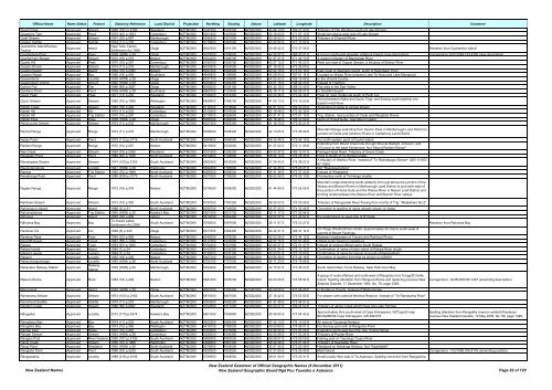
Official Name Name Status Feature Statutory Reference Land District Projection Northing Easting Datum Latitude Longitude Description Comment<br />
Quad Creek Approved Stream 1990 (191) p.4192 Westland NZTM2000 5147200 1307200 NZGD2000 43 46 13 S 169 21 43 E Tributary <strong>of</strong> The Windbag south <strong>of</strong> Lake Paringa<br />
Quagmire Tarn Approved Pond 1979 (42) p.1553 Canterbury NZTM2000 5201600 1447600 NZGD2000 43 19 23 S 171 07 13 E Small tarn above west side <strong>of</strong> Lake Stream<br />
Quail Stream Approved Stream 1991 (32) p.687 Marlborough NZTM2000 5298300 1627900 NZGD2000 42 28 02 S 173 20 22 E Tributary <strong>of</strong> Charwell River<br />
Quaker Saddle Approved Saddle 1974 (11) p.233 Canterbury NZTM2000 5176800 1462500 NZGD2000 43 32 57 S 171 17 52 E<br />
Quarantine Island/Kamau<br />
Taurua<br />
Approved Island<br />
Ngāi Tahu Claims<br />
Settlement Act 1998<br />
Otago NZTM2000 4922300 1416100 NZGD2000 45 49 42 S 170 37 56 E Alteration from Quarantine Island<br />
Quarterdeck Pass Approved Pass 1938 (HON) p.28 Otago NZTM2000 5073000 1259000 NZGD2000 44 24 57 S 168 43 01 E A Col on south-east shoulder <strong>of</strong> Mount French (new description) Corrigendum: 8/12/1994 133:4350 (new description)<br />
Quartermain Stream Approved Stream 1972 (18) p.379 Nelson NZTM2000 5354200 1496700 NZGD2000 41 57 27 S 171 45 13 E A western tributary <strong>of</strong> Blackwater River<br />
Quartz Hill Approved Peak 1970 (10) p.297 Canterbury NZTM2000 5188100 1500700 NZGD2000 43 27 12 S 171 46 22 E Peak just east <strong>of</strong> Copper Stream, a tributary <strong>of</strong> Selwyn River<br />
Quayle Stream Approved Stream 1974 (11) p.233 Marlborough NZTM2000 5424600 1654500 NZGD2000 41 19 42 S 173 39 05 E<br />
Queens Beach Approved Beach 1964 (79) p.2365 Nelson NZTM2000 5497200 1684900 NZGD2000 40 40 18 S 174 00 16 E East coast <strong>of</strong> Stephens Island, south <strong>of</strong> Razorback Point<br />
Queens Reach Approved Bay 1985 (18) p.404 Southland NZTM2000 4949800 1184800 NZGD2000 45 28 54 S 167 41 14 E Located on Waiau River between Lake Te Anau and Lake Manapouri<br />
Queensberry Approved Locality 1939 (HON) p.28 Otago NZTM2000 5027700 1309800 NZGD2000 44 50 42 S 169 19 40 E In the Vincent County<br />
Queenstown Drome Approved Airport 1940 (HON) p.28 Otago NZTM2000 5005800 1264400 NZGD2000 45 01 18 S 168 44 25 E Instead <strong>of</strong> Frankton<br />
Quinns Flat Approved Flat 1986 (89) p.2487 Otago NZTM2000 5058000 1234100 NZGD2000 44 32 18 S 168 23 40 E Flat area in the Dart Valley<br />
Quintano Point Approved Point 1939 (HON) p.28 Southland NZTM2000 4965700 1127600 NZGD2000 45 18 11 S 166 58 27 E In Doubtful Sound<br />
Quoin Peak Approved Peak 1971 (13) p.259 Westland NZTM2000 5198200 1414400 NZGD2000 43 20 46 S 170 42 36 E Peak on main divide just south <strong>of</strong> Perth Col<br />
Quoin Stream Approved Stream 1950 (70) p.1989 Wellington NZTM2000 5458400 1789700 NZGD2000 41 00 13 S 175 15 20 E<br />
Rising between Alpha and Quion Trigs, and flowing south-easterly into<br />
Eastern Hutt River<br />
Rabbit Creek Approved Stream 1983 (18) p.409 Westland NZTM2000 5118700 1319600 NZGD2000 44 01 53 S 169 30 03 E Amending <strong>of</strong> name to correct stream<br />
Rabbit Hill Approved Hill 1974 (11) p.233 Canterbury NZTM2000 5315400 1576000 NZGD2000 42 18 48 S 172 42 32 E<br />
Rabbit Hill Approved Trig Station 1970 (10) p.297 Canterbury NZTM2000 5178300 1426600 NZGD2000 43 31 41 S 170 51 15 E Trig. Station, near junction <strong>of</strong> Clyde and Rangitata Rivers<br />
Rabbit Pass Approved Pass 1938 (HON) p.28 Otago NZTM2000 5085000 1269000 NZGD2000 44 18 46 S 168 50 59 E North <strong>of</strong> PickelHaube, near Mount Castor<br />
Racecourse Stream Approved Stream 1974 (11) p.233 Marlborough NZTM2000 5427400 1656300 NZGD2000 41 18 10 S 173 40 21 E<br />
Rachel Range Approved Range 1974 (11) p.233 Marlborough NZTM2000 5326000 1608400 NZGD2000 42 13 05 S 173 06 06 E<br />
Mountain Range extending from Saxton Pass in Marlborough Land District to<br />
junction <strong>of</strong> Guide and Acheron Rivers in Canterbury Land District<br />
Radar Point Approved Point 1979 (112) p.3715 North Auckland NZTM2000 5964800 1848500 NZGD2000 36 25 48 S 175 46 19 E For north-eastern point <strong>of</strong> Cuvier Island<br />
Radiant Range Approved Range 1970 (10) p.297 Nelson NZTM2000 5410900 1532000 NZGD2000 41 27 02 S 172 11 09 E<br />
Extending from Mount Anaconda through Mounts Radiant, Johnson, and<br />
O'Connor to the peak Kilmarnock. Not "Mount Radiant Range"<br />
Rae Creek Approved Stream 1964 (79) p.2365 Westland NZTM2000 5151500 1295200 NZGD2000 43 43 37 S 169 12 57 E Paringa-Haast Road. Tributary <strong>of</strong> Grave Creek<br />
Raeakiaki Point Approved Point 1989 (62) p.1435 North Auckland NZTM2000 5914800 1728800 NZGD2000 36 54 14 S 174 26 45 E Point to South <strong>of</strong> Te Henga locality<br />
Raeotepapa Stream Approved Stream 1974 (100) p.2163 South Auckland NZTM2000 5852400 1833500 NZGD2000 37 26 45 S 175 38 22 E<br />
A tributary <strong>of</strong> Waihou River. Instead <strong>of</strong> "Te Raeotepapa Stream" (26/11/1953<br />
67:1920)<br />
Raeotutemahuta Approved Locality 1941 (HON) p.28 Wellington NZTM2000 5394300 1795000 NZGD2000 41 34 45 S 175 20 21 E Not "Raeotutemahotu"<br />
Raeroa Approved Trig Station 1950 (70) p.1989 North Auckland NZTM2000 6068300 1656500 NZGD2000 35 31 38 S 173 37 23 E Instead <strong>of</strong> Whakatere<br />
Raetahinga Point Approved Point 1988 (206) p.5173 North Auckland NZTM2000 5917200 1726500 NZGD2000 36 52 58 S 174 25 10 E Promontory north <strong>of</strong> Te Henga locality<br />
Raglan Range Approved Range 1972 (18) p.379 Nelson NZTM2000 5378000 1608200 NZGD2000 41 44 59 S 173 05 55 E<br />
Mountain range extending south-westerly from just above the junction <strong>of</strong> the<br />
Wairau and Branch Rivers in Marlborough Land District to just north-east <strong>of</strong><br />
the junction <strong>of</strong> Horse Gully and the Wairau River in Nelson Lnad District and<br />
forming divide between the Wairau River and Branch River valleys.<br />
Rahiteiwi Stream Approved Stream 1973 (15) p.365 South Auckland NZTM2000 5737500 1767300 NZGD2000 38 29 43 S 174 55 06 E Tributary <strong>of</strong> Mangaotaki River flowing from vicinity <strong>of</strong> Trig. "Matawhero No.2"<br />
Rahomaunu Island Approved Island 1988 (2) p.31 North Auckland NZTM2000 6056700 1740000 NZGD2000 35 37 25 S 174 32 46 E Correction to spelling <strong>of</strong> name already shown on maps<br />
Rahuimokairoa Approved Trig Station 1945 (HON) p.28 Hawke's Bay NZTM2000 5651000 2021700 NZGD2000 39 11 17 S 177 52 54 E<br />
Rahuinui Approved Island 1983 (18) p.409 nelson NZTM2000 5474000 1664400 NZGD2000 40 52 57 S 173 45 52 E For small island on west side <strong>of</strong> D'Urville<br />
Rāhuiroa Bay Approved Bay<br />
Te Arawa Lakes<br />
Settlement Act 2006<br />
South Auckland NZTM2000 5768200 1897000 NZGD2000 38 11 07 S 176 23 27 E Alteration from Rahuiroa Bay<br />
Rainbow Col Approved Col 1969 (8) p.240 Otago NZTM2000 5077500 1264400 NZGD2000 44 22 41 S 168 47 14 E<br />
On Otago Westlandmain divide, approximately 50 chains south-west <strong>of</strong><br />
summit <strong>of</strong> Mount Fastness<br />
Rainbow Pass Approved Pass 1949 (22) p.858 Nelson NZTM2000 5346300 1578200 NZGD2000 42 02 06 S 172 44 12 E Between headwaters <strong>of</strong> Travers and Rainbow Rivers<br />
Raincliff Forest Approved Forest 1981 (58) p.1326 Canterbury NZTM2000 5112700 1437000 NZGD2000 44 07 15 S 170 57 46 E Oldest exotic forest in canterbury<br />
Rakaia Approved Town 1953 (67) p.1920 Canterbury NZTM2000 5154300 1521900 NZGD2000 43 45 37 S 172 01 47 E Instead <strong>of</strong> original <strong>of</strong>ficial name South Rakaia<br />
Rakaia Island Approved Island 1984 (1) p.24 Canterbury NZTM2000 5143700 1533300 NZGD2000 43 51 24 S 172 10 12 E Confirmation <strong>of</strong> name <strong>of</strong> main island at Rakaia River mouth<br />
Rakaia Lagoon Approved Lagoon 1984 (1) p.24 Canterbury NZTM2000 5139200 1537100 NZGD2000 43 53 51 S 172 13 00 E Confirmation <strong>of</strong> name for lagoon at mouth <strong>of</strong> Rakaia River<br />
Rakariri Approved Locality 1983 (18) p.409 Nelson NZTM2000 5467200 1664900 NZGD2000 40 56 38 S 173 46 16 E Correction <strong>of</strong> spelling from that as shown on NZMS1<br />
Rakaumangamanga Approved Locality 1940 (HON) p.28 North Auckland NZTM2000 6105100 1721000 NZGD2000 35 11 23 S 174 19 45 E<br />
Rakautara Railway Station Approved<br />
Railway<br />
Station<br />
1939 (HON) p.28 Marlborough NZTM2000 5320400 1666500 NZGD2000 42 15 57 S 173 48 23 E South Island Main Trunk Railway. Near Half-moon Bay<br />
Rakiura Rocks Approved Rock 1983 (18) p.409 Nelson NZTM2000 5491400 1678700 NZGD2000 40 43 29 S 173 55 54 E<br />
A group <strong>of</strong> rocks <strong>of</strong>fshore and north-west <strong>of</strong> Rangitoto ki te Tonga/D’Urville<br />
Island. Spelling alteration from Rangiura Rocks and replacing previous <strong>New</strong><br />
<strong>Zealand</strong> Gazette, 17 December 1964, No. 79, page 2365.<br />
Ram Island Approved Island 1930 (HON) p.28 Otago NZTM2000 4902200 1376300 NZGD2000 45 59 50 S 170 06 40 E In the Bruce County. Instead <strong>of</strong> Waihorapuke<br />
Ramarama Stream Approved Stream 1974 (100) p.2163 South Auckland NZTM2000 5870300 1857000 NZGD2000 37 16 42 S 175 53 55 E For stream with outlet at Whiritoa Reserve. Instead <strong>of</strong> "Te Ramarama River"<br />
Ramshead Saddle Approved Saddle 1974 (11) p.233 Marlborough NZTM2000 5383600 1662200 NZGD2000 41 41 49 S 173 44 51 E<br />
Random Creek Approved Stream 1986 (89) p.2487 Westland NZTM2000 5152500 1311200 NZGD2000 43 43 27 S 169 24 52 E Tributary <strong>of</strong> Jamie Creek which flows into Lake Paringa<br />
Rāngaiika Approved Locality 2010 (173) p.4274 Hawke's Bay NZTM2000 5601600 1949900 NZGD2000 39 39 50 S 177 04 43 E<br />
Approximately 2km south-west <strong>of</strong> Cape Kidnappers. NZTopo50 map<br />
BK40ptBK39-Cape Kidnappers, GR 499 016.<br />
Corrigendum: 14/05/2009 66:1497 (amending description)<br />
Spelling alteration from Rangaiika (macron added).Rreplaces<br />
previous <strong>New</strong> <strong>Zealand</strong> Gazette, 14 May 2009, No. 66, page 1498.<br />
Rangataua Bay Approved Bay 1974 (11) p.233 South Auckland NZTM2000 5822200 1883400 NZGD2000 37 42 13 S 176 12 52 E An area at Tauranga Harbour<br />
Rangatira Bay Approved Bay 1973 (15) p.365 Wellington NZTM2000 5476100 1763000 NZGD2000 40 50 60 S 174 56 01 E For the bay just north <strong>of</strong> Rangarira Point<br />
Ranger Spur Approved Ridge 1970 (10) p.297 Canterbury NZTM2000 5163500 1416900 NZGD2000 43 39 32 S 170 43 45 E Extending south-east from the Two Thumb Range<br />
Ranger Stream Approved Stream 1943 (HON) p.28 Canterbury NZTM2000 5256200 1509300 NZGD2000 42 50 29 S 171 53 24 E Tributary <strong>of</strong> Poulter River<br />
Rangers Pool Approved River Feature 1990 (191) p.4192 South Auckland NZTM2000 5686350 1853030 NZGD2000 38 56 07 S 175 55 09 E Fishing pool on Tauranga Taupo River<br />
Rangi Creek Approved Stream 1950 (70) p.1989 Wellington NZTM2000 5586800 1867300 NZGD2000 39 49 36 S 176 07 24 E Tributary <strong>of</strong> Kawhatau River<br />
Rangi Point Approved Headland 1945 (HON) p.28 North Auckland NZTM2000 6075600 1634500 NZGD2000 35 27 45 S 173 22 49 E Headland on Hokianga Harbour. Not "Kawehetiki"<br />
Rangiaho Point Approved Point 1988 (93) p.2239 South Auckland NZTM2000 5829500 1902500 NZGD2000 37 37 55 S 176 25 40 E Motiti Island Corrigendum: 1/12/1988 206:5176 (amending position)<br />
Rangiaowhia Approved Locality 1989 (216) p.6106 South Auckland NZTM2000 5789500 1808500 NZGD2000 38 01 06 S 175 22 31 E Small locality 5km east <strong>of</strong> Te Awamutu. Spelling correction from Rangiaohia<br />
<strong>New</strong> <strong>Zealand</strong> <strong>Names</strong><br />
<strong>New</strong> <strong>Zealand</strong> <strong>Gazetteer</strong> <strong>of</strong> Official Geographic <strong>Names</strong> (8 <strong>November</strong> <strong>2011</strong>)<br />
<strong>New</strong> <strong>Zealand</strong> Geographic Board Ngā Pou Taunaha o Aotearoa Page 82 <strong>of</strong> 120


