

Gazetteer of New Zealand Names - 3 November 2011
Gazetteer of New Zealand Names - 3 November 2011
Gazetteer of New Zealand Names - 3 November 2011

You also want an ePaper? Increase the reach of your titles
YUMPU automatically turns print PDFs into web optimized ePapers that Google loves.
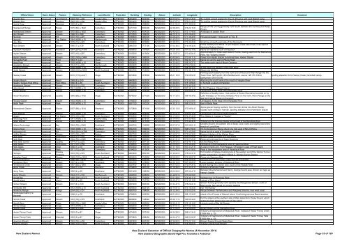
Official Name Name Status Feature Statutory Reference Land District Projection Northing Easting Datum Latitude Longitude Description Comment<br />
Hawke's Bay Approved Land District 1983 (18) p.409 Hawke's Bay NZTM2000 5624400 1932300 NZGD2000 39 27 57 S 176 51 45 E To confirm correct spelling for County Province and Land District name<br />
Hawke's Bay Approved Province 1983 (18) p.409 Hawke's Bay NZTM2000 5624400 1932300 NZGD2000 39 27 57 S 176 51 45 E To confirm correct spelling for County Province and Land District name<br />
Hawks Crag Approved Mountain 1950 (4) p.39 Nelson NZTM2000 5364500 1498800 NZGD2000 41 51 54 S 171 46 50 E<br />
Hawkswood Range Approved Range 1975 (62) p.1632 Canterbury NZTM2000 5277100 1630400 NZGD2000 42 39 29 S 173 22 15 E<br />
Range <strong>of</strong> hills running generally north-south between the Conway and Waiau<br />
Rivers<br />
Hawkswood Stream Approved Stream 1975 (62) p.1632 Canterbury NZTM2000 5272400 1624300 NZGD2000 42 42 02 S 173 17 48 E A tributary <strong>of</strong> Leader River<br />
Hay Stream Approved Stream 1968 (9) p.268 Canterbury NZTM2000 5077800 1399300 NZGD2000 44 25 31 S 170 28 43 E<br />
Haycock Approved Hill 1970 (10) p.297 Canterbury NZTM2000 5189500 1490500 NZGD2000 43 26 22 S 171 38 49 E Hill approximately 1 mile south <strong>of</strong> Trig. B<br />
Haycock Approved Trig Station 1944 (HON) p.10 Marlborough NZTM2000 5383400 1632800 NZGD2000 41 42 02 S 173 23 39 E<br />
Hays Bay Approved Bay 1978 (13) p.422 Canterbury NZTM2000 5168200 1576800 NZGD2000 43 38 20 S 172 42 45 E Small bay at south-west side <strong>of</strong> the Peninsula<br />
Hays Stream Approved Stream 1960 (7) p.139 North Auckland NZTM2000 5894700 1777100 NZGD2000 37 04 38 S 174 59 32 E<br />
Flows westerly from Block I to join Slippery Creek about half a mile west <strong>of</strong><br />
Opaheke Railway Station<br />
Haystack Headland Approved Headland 1984 (204) p.4798 Southland NZTM2000 5066800 1191800 NZGD2000 44 26 13 S 167 52 15 E Name for headland south <strong>of</strong> Haystack<br />
Hayter Stream Approved Stream 1970 (10) p.297 Canterbury NZTM2000 5105200 1413600 NZGD2000 44 10 57 S 170 40 04 E<br />
Approximately 12 miles south-west <strong>of</strong> Fairlie, flowing east from the Mackenzie<br />
Pass. Not "Dalgety Stream"<br />
Hayter Stream Approved Stream 1992 (169) p.3464 Canterbury NZTM2000 5159400 1366500 NZGD2000 43 40 54 S 170 06 11 E Flows from Hayter Glacier to terminal face, Hooker Glacier<br />
Haywards Point Approved Point 1984 (1) p.24 Otago NZTM2000 4837400 1334600 NZGD2000 46 33 52 S 169 32 13 E Name for point to east <strong>of</strong> Pillans Head<br />
Head Peak Approved Peak 1938 (HON) p.10 Otago NZTM2000 5055400 1235300 NZGD2000 44 33 44 S 168 24 27 E Two miles north-east <strong>of</strong> Mount Cerberus<br />
Headache Stream Approved Stream 1974 (11) p.233 Marlborough NZTM2000 5362900 1680200 NZGD2000 41 52 54 S 173 57 60 E<br />
Headlong Peaks Approved Peak 1938 (HON) p.10 Otago NZTM2000 5058600 1250200 NZGD2000 44 32 28 S 168 35 49 E At the head <strong>of</strong> a tributary <strong>of</strong> the Dart River<br />
Heale Stream Approved Stream 1989 (120) p.3005 North Auckland NZTM2000 5904700 1742800 NZGD2000 36 59 35 S 174 36 17 E Glows into Mill Bay<br />
Flowing south-easterly from the north end <strong>of</strong> Rock and Pillar Range into the<br />
Heaney Creek Approved Stream 2010 (173) p.4271 Otago NZTM2000 4973600 1375500 NZGD2000 45 21 18 S 170 08 02 E Taieri River. NZTopo50 CD16-Middlemarch, source: GR 755 736 to<br />
confluence: GR 818 706.<br />
Spelling alteration from Heeney Creek (recorded name).<br />
Heaphy Beach Approved Beach 1969 (8) p.240 Nelson NZTM2000 5460800 1525000 NZGD2000 41 00 02 S 172 06 30 E Adjoining the south bank at the mouth <strong>of</strong> Heaphy River<br />
Heaphy Terrace Post Office Approved Post Office 1950 (4) p.39 South Auckland NZTM2000 5817000 1801000 NZGD2000 37 46 20 S 175 16 56 E In Fairfield a suburb <strong>of</strong> Hamilton<br />
Heathstock Stream Approved Stream 1974 (11) p.233 Canterbury NZTM2000 5238300 1560000 NZGD2000 43 00 25 S 172 30 33 E<br />
Hebe Island Approved Island 1941 (HON) p.10 Southland NZTM2000 4756700 1194000 NZGD2000 47 13 03 S 167 38 14 E In Port Pegasus, Stewart Island<br />
Hector Glacier Approved Glacier 1934 (HON) p.10 Canterbury NZTM2000 5199100 1424400 NZGD2000 43 20 26 S 170 50 01 E Unmapped. At the head <strong>of</strong> the Rangitata River<br />
Definition <strong>of</strong> locality name - that portion <strong>of</strong> Hector Mountains bounded on by<br />
Hector Mountains Approved Locality 1980 (66) p.1752 Otago NZTM2000 4976000 1271500 NZGD2000 45 17 33 S 168 48 38 E Lake Wakatipu on the west, Kawarau River on the north, Nevis Range on the<br />
east and Garvie Range on the south<br />
Hecuba Glacier Approved Glacier 1934 (HON) p.10 Canterbury NZTM2000 5198300 1424600 NZGD2000 43 20 52 S 170 50 09 E Unmapped. At the head <strong>of</strong> the Rangitata River<br />
Hedin Peak Approved Peak 1938 (HON) p.10 Otago NZTM2000 5061100 1230200 NZGD2000 44 30 31 S 168 20 52 E East <strong>of</strong> Betty Peak<br />
Heemskerck Glacier Approved Glacier 2007 (58) p.1514 Westland NZTM2000 5173800 1371000 NZGD2000 43 33 13 S 170 09 54 E<br />
Alpine glacier flowing northerly from the main divide into Albert Glacier,<br />
located north <strong>of</strong> Mount Tasman. Spelling alteration from Heemskirk Glacier<br />
Heim Plateau Approved Plateau 1934 (HON) p.10 Canterbury NZTM2000 5204800 1424500 NZGD2000 43 17 21 S 170 50 12 E Unmapped. In the Upper Rakaia District<br />
Heipipi Approved Trig Station 1973 (15) p.365 South Auckland NZTM2000 5760500 1757000 NZGD2000 38 17 23 S 174 47 43 E Trig. Station L. Instead <strong>of</strong> "Hepipi"<br />
Hekerangi Point Approved Point 1941 (HON) p.10 Hawke's Bay NZTM2000 5646000 2018400 NZGD2000 39 14 04 S 177 50 48 E<br />
Helen Glacier Approved Glacier 1935 (HON) p.10 Canterbury NZTM2000 5199900 1417000 NZGD2000 43 19 53 S 170 44 34 E Tributary to the Frances Glacier at the head <strong>of</strong> the Rangitata River<br />
Helena Anchorage Approved Bay 1964 (79) p.2365 Southland NZTM2000 4948700 1143800 NZGD2000 45 27 57 S 167 09 51 E<br />
Doubtful Sound. At southern end <strong>of</strong> Deep Cove, north and slightly east <strong>of</strong> the<br />
mouth <strong>of</strong> Lyvia River<br />
Helena Peak Approved Peak 1938 (HON) p.10 Westland NZTM2000 5094100 1269800 NZGD2000 44 13 53 S 168 51 56 E On Commissioner Range about one mile west <strong>of</strong> Mount Pollux<br />
Helicopter Hill Approved Hill 1984 (204) p.4798 Canterbury NZTM2000 5222600 1496300 NZGD2000 43 08 32 S 171 43 29 E Name for hill to west <strong>of</strong> Craigieburn Cutting<br />
Hellfire Stream Approved Stream 1972 (18) p.379 Nelson NZTM2000 5357700 1592600 NZGD2000 41 55 57 S 172 54 39 E Eastern tributary <strong>of</strong> the Wairau River<br />
Hells Gate Approved Hill Feature 1974 (11) p.233 Canterbury NZTM2000 5151100 1387800 NZGD2000 43 45 46 S 170 21 50 E A steep sided approach to a rock ledge<br />
Hells Gate Approved Rock 1964 (79) p.2365 Nelson NZTM2000 5495000 1680800 NZGD2000 40 41 31 S 173 57 23 E Rocks at north-east tip <strong>of</strong> Cape Stephens<br />
Hells Gate Corner Approved Locality 1974 (11) p.233 Canterbury NZTM2000 5283500 1581100 NZGD2000 42 36 03 S 172 46 11 E On the Waiau River<br />
Hells Gates Approved Hill Feature 1971 (13) p.259 Canterbury NZTM2000 5198500 1430900 NZGD2000 43 20 50 S 170 54 49 E Hill feature in the headwaters area <strong>of</strong> Lawrence River<br />
Hells Gates Approved Strait 1966 (1) p.18 Southland NZTM2000 4760300 1197700 NZGD2000 47 11 15 S 167 41 21 E A strait in North Arm, Port Pegasus. Off western coast <strong>of</strong> Pearl Island<br />
Helmet Peak Approved Peak 1971 (13) p.259 Canterbury NZTM2000 5194600 1413600 NZGD2000 43 22 42 S 170 41 56 E Peak in the headwaters area <strong>of</strong> Haveloack River<br />
Hemopo Approved<br />
Railway<br />
Crossing<br />
1972 (18) p.379 South Auckland NZTM2000 5823600 1850700 NZGD2000 37 42 02 S 175 50 37 E<br />
For location <strong>of</strong> railway crossing loop at the western end <strong>of</strong> the Kaimai Tunnel<br />
under construction, situated in Block X, Wairere Survey District<br />
Hemsley Creek Approved Stream 1989 (120) p.3005 North Auckland NZTM2000 5905500 1743800 NZGD2000 36 59 08 S 174 36 57 E Flows into Swanson Bay<br />
Hen and Chickens Approved Area 1996 (94) p.2470 Taranaki NZTM2000 5650500 1693300 NZGD2000 39 17 23 S 174 04 55 E General area <strong>of</strong> Tahurangi Lodge and TV Transmitter<br />
Henderson Burn Approved Stream 1967 (4) p.120 Southland NZTM2000 5004700 1178800 NZGD2000 44 59 10 S 167 39 26 E Larger western tributary <strong>of</strong> Glaisnock River<br />
Hendersons Creek Approved Stream 1987 (62) p.1964 Otago NZTM2000 5020400 1435100 NZGD2000 44 57 03 S 170 54 34 E Creek flowing into a water race, south <strong>of</strong> the Waitaki River<br />
Henry Creek Approved Stream 1984 (1) p.24 Westland NZTM2000 5314800 1481200 NZGD2000 42 18 36 S 171 33 31 E Tributary <strong>of</strong> Moores Creek<br />
Henry Pass Approved Pass 1950 (4) p.39 Southland NZTM2000 5001400 1166300 NZGD2000 45 00 29 S 167 29 47 E<br />
Between Mounts Murrell and Henry, George Sound area. Shown on maps as<br />
Henry's Saddle<br />
Henry Stream Approved Stream 1974 (11) p.233 Marlborough NZTM2000 5369000 1608900 NZGD2000 41 49 51 S 173 06 26 E<br />
Herald Bay Approved Bay 1988 (206) p.5173 North Auckland NZTM2000 5901200 1742600 NZGD2000 37 01 28 S 174 36 11 E Northern bay on Puponga Point<br />
Herald Island Approved Island 1950 (4) p.39 North Auckland NZTM2000 5928300 1747700 NZGD2000 36 46 47 S 174 39 19 E Instead <strong>of</strong> Pine Island<br />
Herbert Stream Approved Stream 2007 (4) p.120 South Auckland NZTM2000 5837900 1820300 NZGD2000 37 34 47 S 175 29 41 E<br />
Stream flowing generally north-easterly into Mangarewa Stream, north <strong>of</strong><br />
Morrinsville. Not named on current mapping<br />
Herekareo Hill Approved Hill 1943 (HON) p.10 North Auckland NZTM2000 6099300 1625100 NZGD2000 35 14 57 S 173 16 33 E Not "Herekariau"<br />
Herekohu Range Approved Range 2004 (33) p.751 North Auckland NZTM2000 5990700 1784900 NZGD2000 36 12 39 S 175 03 25 E Range between Parihakoakoa and Waipawa Streams, near west coast<br />
Herekopare Island (Te<br />
Marama)<br />
Approved Island 1998 (1) p.78 Southland NZTM2000 4798600 1236300 NZGD2000 46 51 60 S 168 13 39 E Island <strong>of</strong> the E coast <strong>of</strong> Stewart Island. Confirming previous Board decision<br />
Herrick Creek Approved Stream 1972 (18) p.379 Southland NZTM2000 4928490 1128040 NZGD2000 45 38 11 S 166 56 39 E<br />
For the stream at the southern side <strong>of</strong> Wet Jacket Arm, Dusky Sound, which<br />
enters the fiord almost due east <strong>of</strong> Oke Island<br />
Herrick Spur Approved Ridge 1950 (70) p.1989 Hawke's Bay NZTM2000 5612000 1883800 NZGD2000 39 35 41 S 176 18 18 E Lying to south <strong>of</strong> Big Hill Stream<br />
Hervey Gorge Approved Gorge 1943 (HON) p.10 Canterbury NZTM2000 5262600 1507600 NZGD2000 42 47 01 S 171 52 13 E<br />
Heslop Creek Approved Stream 1968 (9) p.268 Nelson NZTM2000 5318200 1520500 NZGD2000 42 17 04 S 172 02 09 E Small tributary <strong>of</strong> the Inangahua River<br />
Hester Pinney Creek Approved Stream 1953 (3) p.87 Otago NZTM2000 5074500 1270300 NZGD2000 44 24 28 S 168 51 34 E<br />
Tributary <strong>of</strong> East branch <strong>of</strong> Matukituki River. Instead <strong>of</strong> Hestor Pinney Creek<br />
(1938 Hon p. 10)<br />
Hester Pinney Falls Approved Waterfall 1953 (3) p.87 Otago NZTM2000 5073800 1268400 NZGD2000 44 24 47 S 168 50 06 E<br />
Tributary <strong>of</strong> East branch <strong>of</strong> Matukituki River. Instead <strong>of</strong> Hestor Pinney Falls<br />
(1938 Hon p. 10)<br />
Hewsons Stream Approved Stream 1983 (18) p.409 Canterbury NZTM2000 5281800 1630300 NZGD2000 42 36 56 S 173 22 10 E Stream flowing through Weka Pass<br />
Hibernia Stream Approved Stream 1989 (120) p.3005 North Auckland NZTM2000 5912400 1747100 NZGD2000 36 55 23 S 174 39 05 E Tributary Waikumete Stream<br />
<strong>New</strong> <strong>Zealand</strong> <strong>Names</strong><br />
<strong>New</strong> <strong>Zealand</strong> <strong>Gazetteer</strong> <strong>of</strong> Official Geographic <strong>Names</strong> (8 <strong>November</strong> <strong>2011</strong>)<br />
<strong>New</strong> <strong>Zealand</strong> Geographic Board Ngā Pou Taunaha o Aotearoa Page 32 <strong>of</strong> 120


