

Gazetteer of New Zealand Names - 3 November 2011
Gazetteer of New Zealand Names - 3 November 2011
Gazetteer of New Zealand Names - 3 November 2011

Create successful ePaper yourself
Turn your PDF publications into a flip-book with our unique Google optimized e-Paper software.
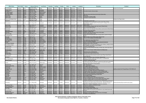
Official Name Name Status Feature Statutory Reference Land District Projection Northing Easting Datum Latitude Longitude Description Comment<br />
Pig Island/Mātau Approved Island<br />
Ngāi Tahu Claims<br />
Settlement Act 1998<br />
Otago NZTM2000 5012700 1237600 NZGD2000 44 56 48 S 168 24 22 E Alteration from Pig Island<br />
Pig Spur Stream Approved Stream 1968 (9) p.268 Canterbury NZTM2000 5243200 1529900 NZGD2000 42 57 38 S 172 08 26 E<br />
Pig Stream Approved Stream 1975 (62) p.1632 Canterbury NZTM2000 5262100 1561400 NZGD2000 42 47 34 S 172 31 41 E A southern tributary <strong>of</strong> Hurunui River<br />
Pig Wallow Stream Approved Stream 1989 (120) p.3005 North Auckland NZTM2000 5913000 1733700 NZGD2000 36 55 10 S 174 30 04 E<br />
Pig Whare Saddle Approved Saddle 1974 (11) p.233 Marlborough NZTM2000 5380700 1658500 NZGD2000 41 43 24 S 173 42 12 E<br />
Pigeon Bay Stream Approved Stream 1976 (110) p.2453 Canterbury NZTM2000 5162100 1591500 NZGD2000 43 41 39 S 172 53 40 E The main stream which flows into the head <strong>of</strong> Pigeon Bay<br />
Pigeon Bush Approved Bush 1974 (11) p.233 Canterbury NZTM2000 5228900 1543700 NZGD2000 43 05 26 S 172 18 30 E Bush area<br />
Pigeon Creek Approved Stream 1984 (204) p.4798 Otago NZTM2000 4970600 1424900 NZGD2000 45 23 46 S 170 45 46 E Confirmation <strong>of</strong> name <strong>of</strong> creek<br />
Pigeon Creek Approved Stream 1972 (18) p.379 Nelson NZTM2000 5356700 1480200 NZGD2000 41 55 57 S 171 33 18 E A tributary <strong>of</strong> Little Totara River<br />
Pigeon Island/Wāwāhi Waka Approved Island<br />
Ngāi Tahu Claims<br />
Settlement Act 1998<br />
Otago NZTM2000 5015200 1236400 NZGD2000 44 55 25 S 168 23 34 E Alteration from Pigeon Island<br />
Pigroot Hill Approved Hill 1984 (204) p.4798 Otago NZTM2000 4990800 1398300 NZGD2000 45 12 27 S 170 25 54 E Confirmation <strong>of</strong> name <strong>of</strong> hill<br />
Confirmed name for a small island, in Chew Tobacco Bay, Stewart<br />
Pihore Island Approved Island 2001 (149) p.3705 Southland NZTM2000 4782800 1236000 NZGD2000 47 00 29 S 168 12 40 E Island/Rakiura. Currently shown as Pihore Island on mapping. Also known as<br />
Chew Tobacco Island<br />
Pikaroro Bay Approved Bay 1941 (HON) p.26 Southland NZTM2000 4779500 1236000 NZGD2000 47 02 16 S 168 12 30 E Stewart Island<br />
Pikaroro Point Approved Point 1966 (1) p.18 Southland NZTM2000 4779800 1236700 NZGD2000 47 02 07 S 168 13 04 E Point north-east <strong>of</strong> Pikaroro (bay) east coast <strong>of</strong> Stewart Island<br />
Pikaroro Point Approved Point 1988 (206) p.5173 North Auckland NZTM2000 5901200 1741600 NZGD2000 37 01 29 S 174 35 31 E North side Manukau Entrance<br />
Pikes Creek Approved Stream 1963 (76) p.1921 Marlborough NZTM2000 5354800 1674200 NZGD2000 41 57 19 S 173 53 43 E Blocks VII and VIII, Whernside Survey District. South branch <strong>of</strong> Wharf Stream<br />
Pikes Peak Approved Peak 1970 (10) p.297 Canterbury NZTM2000 5155900 1397800 NZGD2000 43 43 21 S 170 29 23 E At head <strong>of</strong> Pikes Peak Stream<br />
Pikes Peak Stream Approved Stream 1970 (10) p.297 Canterbury NZTM2000 5155000 1399600 NZGD2000 43 43 51 S 170 30 42 E Tributary <strong>of</strong> Godley River<br />
Pillar Rock Approved Rock 1966 (1) p.18 Southland NZTM2000 4790900 1227700 NZGD2000 46 55 51 S 168 06 32 E Paterson Inlet. Rock <strong>of</strong>f western shore <strong>of</strong> Ulva Island<br />
Pillow Lava Bay Approved Bay 1988 (206) p.5173 North Auckland NZTM2000 5921200 1726500 NZGD2000 36 50 48 S 174 25 08 E South <strong>of</strong> Muriwai Beach locality<br />
Pinakitanga Point Approved Point 1967 (4) p.120 North Auckland NZTM2000 6071500 1757900 NZGD2000 35 29 15 S 174 44 26 E<br />
Small point on the south-east coast <strong>of</strong> Aorangi Island, opposite Aorangaia<br />
Island<br />
Pinch Gut Approved Bay 1966 (1) p.18 Southland NZTM2000 4792600 1231200 NZGD2000 46 55 03 S 168 09 22 E Bay at southern shore <strong>of</strong> Native Island, Paterson Inlet<br />
Pinchback Approved Locality 1970 (10) p.297 Nelson NZTM2000 5400900 1580500 NZGD2000 41 32 36 S 172 45 58 E Trig. D, 2,118 ft, situated on Pinchback Ridge<br />
Pinchgut Stream Approved Stream 1974 (11) p.233 Canterbury NZTM2000 5223400 1545600 NZGD2000 43 08 25 S 172 19 52 E<br />
Pine Tree Saddle Approved Saddle 1975 (62) p.1632 Marlborough NZTM2000 5285000 1630500 NZGD2000 42 35 13 S 173 22 18 E For saddle above head <strong>of</strong> Mick Stream<br />
Pine Valley Approved Locality 1931 (HON) p.26 North Auckland NZTM2000 5944800 1746100 NZGD2000 36 37 52 S 174 38 03 E This name replaces White Hills<br />
Pinehill Approved Suburb 2008 (84) p.2290 North Auckland NZTM2000 5933500 1753800 NZGD2000 36 43 54 S 174 43 21 E Suburb centred around NZMG coordinate 2664330E 6495300N<br />
Pines Beach Wetlands Approved Swamp 1982 (76) p.2163 Canterbury NZTM2000 5197500 1575300 NZGD2000 43 22 30 S 172 41 42 E Swampy area to north <strong>of</strong> The Pines<br />
Pines Railway Station Approved<br />
Railway<br />
Station<br />
1998 (1) p.78 Marlborough NZTM2000 5327300 1672200 NZGD2000 42 12 11 S 173 52 28 E<br />
Railway station on the Main North Railway south <strong>of</strong> Wainui. Change od name<br />
from Papatea. Not named on current mapping<br />
Pinnacle Creek Approved Stream 1950 (70) p.1989 Wellington NZTM2000 5585900 1865900 NZGD2000 39 50 07 S 176 06 26 E Tributary <strong>of</strong> Kawhatau River<br />
Pinnacle Head Approved Headland 1953 (3) p.87 South Auckland NZTM2000 5838500 1970400 NZGD2000 37 31 34 S 177 11 28 E<br />
Sharp promontory between Shark Bay and Wilson Bay, White Island, Bay <strong>of</strong><br />
Plenty<br />
Pinnacle Stream Approved Stream 1982 (76) p.2163 Hawke's Bay NZTM2000 5646900 1894900 NZGD2000 39 16 38 S 176 25 07 E Name <strong>of</strong> stream flowing in Makahu Stream from Makahu Spur<br />
Pinnacle Stream Approved Stream 1968 (9) p.268 Marlborough NZTM2000 5368900 1626500 NZGD2000 41 49 53 S 173 19 09 E<br />
Pioke Approved Peak 1994 (133) p.4349 Taranaki NZTM2000 5664100 1683600 NZGD2000 39 10 06 S 173 58 04 E Prominent peak on Kaitake Range<br />
Pioneer Pass Approved Pass 1935 (HON) p.26 Canterbury NZTM2000 5173200 1372600 NZGD2000 43 33 34 S 170 11 04 E Between Mount Haast and Mount Grey<br />
Pioneer Stream Approved Stream 1968 (9) p.268 Canterbury NZTM2000 5222300 1541000 NZGD2000 43 08 59 S 172 16 28 E<br />
Pipers Stream Approved Stream 1976 (110) p.2453 Canterbury NZTM2000 5154900 1595300 NZGD2000 43 45 32 S 172 56 30 E<br />
The stream which flows along the southern side <strong>of</strong> Pipers Valley Road to<br />
Duvauchelle Bay<br />
Pipi Rocks Approved Rock 1966 (1) p.18 Southland NZTM2000 4790300 1231800 NZGD2000 46 56 19 S 168 09 43 E Rocks <strong>of</strong>f the western coast <strong>of</strong> The Neck, Paterson Inlet<br />
Pipi Tuaraki Stream Approved Stream 1997 (60) p.1403 Southland NZTM2000 4871000 1167000 NZGD2000 46 10 36 S 167 23 23 E<br />
Stream on Southern Coast <strong>of</strong> the South Island in Te Waewae Bay.<br />
Sometimes known as Flat Creek<br />
Pipikarihi Stream Approved Stream 1949 (22) p.858 South Auckland NZTM2000 5792800 1881500 NZGD2000 37 58 08 S 176 12 16 E Tributary <strong>of</strong> Mangorewa River<br />
Locality 10km north-east <strong>of</strong> Blenheim, generally bounded west by Neal Road,<br />
Pipitea Approved Locality 2005 (177) p.4510 Marlborough NZTM2000 5413100 1685100 NZGD2000 41 25 45 S 174 01 07 E north by Rarangi Road, east by the coastline, and south by the Wairau<br />
Diversion. Not named on current mapping<br />
Pipiwharauroa Approved Locality 1941 (HON) p.26 Gisborne NZTM2000 5782200 2071500 NZGD2000 37 59 07 S 178 22 02 E Not "Pipiwhauraroa"<br />
Pireka (Low Neck Bay) Approved Bay 1983 (18) p.409 Nelson NZTM2000 5483400 1679900 NZGD2000 40 47 47 S 173 56 50 E For original name <strong>of</strong> this bay<br />
Piritoka Point Approved Point 1974 (11) p.233 South Auckland NZTM2000 5797200 1760200 NZGD2000 37 57 31 S 174 49 25 E At northern shores <strong>of</strong> Aotea Harbour<br />
Piritoki Reef Approved Reef 1973 (15) p.365 South Auckland NZTM2000 5751000 1742600 NZGD2000 38 22 40 S 174 37 57 E Marine reef <strong>of</strong>fshore from Tirua Point<br />
Pirongiha Stream Approved Stream 1993 (133) p.2758 Taranaki NZTM2000 5663900 1684200 NZGD2000 39 10 12 S 173 58 29 E Flows into Oakura River from Te Iringa Spelling correction from Pirongia Stream (12/01/1984 p.24)<br />
Pisa Rock Approved Rock 1974 (100) p.2163 North Auckland NZTM2000 5903200 1874700 NZGD2000 36 58 38 S 176 05 10 E The high rock between "Big Hump" and Ruamahuaiti<br />
Pisgah Creek Approved Stream 1967 (4) p.120 Southland NZTM2000 4992300 1166200 NZGD2000 45 05 22 S 167 29 15 E Tributary <strong>of</strong> Doon River, flowing from vicinity <strong>of</strong> Mount Pisgah<br />
Pisgah Hill Approved Hill 1968 (9) p.268 Nelson NZTM2000 5469600 1591600 NZGD2000 40 55 29 S 172 54 01 E Height 3,526 feet, approximately one mile south <strong>of</strong> "Murray Peak"<br />
Pistol Peak Approved Peak 1934 (HON) p.26 Canterbury NZTM2000 5199600 1425500 NZGD2000 43 20 10 S 170 50 51 E Unmapped. At the headwaters <strong>of</strong> the Rangitata River<br />
Pito Peak Approved Peak 1949 (22) p.858 Canterbury NZTM2000 5192400 1434100 NZGD2000 43 24 11 S 170 57 04 E On the Arrowsmith Range south <strong>of</strong> South Peak<br />
Pivot Peak Approved Peak 1945 (HON) p.26 Otago NZTM2000 5068700 1247300 NZGD2000 44 26 56 S 168 34 02 E On the Barrier Range<br />
Plata Col Approved Col 1970 (10) p.297 Canterbury NZTM2000 5175300 1411200 NZGD2000 43 33 05 S 170 39 46 E Just south-west <strong>of</strong> "Graf Spee"<br />
Plateau Creek Approved Stream 1990 (191) p.4192 Westland NZTM2000 5155000 1329300 NZGD2000 43 42 31 S 169 38 24 E Flows into Mahitahi River from Bannock Brae Range<br />
Platform Point Approved Point 1962 (73) p.2021 Marlborough NZTM2000 5446000 1635500 NZGD2000 41 08 12 S 173 25 23 E A wave cut platform jutting out on the northern side <strong>of</strong> Pepin Island<br />
Plato Creek Approved Stream 1963 (76) p.1921 Southland NZTM2000 5014500 1209900 NZGD2000 44 54 57 S 168 03 28 E Tributary <strong>of</strong> Eglinton River. One mile south <strong>of</strong> Cascade Creek<br />
Assigning the existing recorded suburb name <strong>of</strong> Plimmerton and altering the<br />
Plimmerton Approved Suburb <strong>2011</strong> (168) p.4696 Wellington NZTM2000 5451800 1755900 NZGD2000 41 04 12 S 174 51 20 E<br />
existing recorded suburb name <strong>of</strong> Karehana Bay. NZTopo50 BP31-Porirua,<br />
GR 559 518 and NZTopo50 BP32-Paraparaumu, GR 569 517 (NZTM:<br />
5451700 N 1756900 E; NZGD2000: 41 04 15 S 174 52 03 E).<br />
Replacing Karehana Bay (recorded suburb name).<br />
Ploughman Creek Approved Stream 1975 (62) p.1632 Canterbury NZTM2000 5277200 1636100 NZGD2000 42 39 25 S 173 26 26 E Flows out to coast from Hawkswood Range<br />
Plum Pudding Stream Approved Stream 1989 (120) p.3005 North Auckland NZTM2000 5915300 1739200 NZGD2000 36 53 53 S 174 33 44 E Flows into Lake Wainamu<br />
Plumbago Stream Approved Stream 1944 (HON) p.26 Wellington NZTM2000 5416200 1758500 NZGD2000 41 23 24 S 174 53 45 E East tributary <strong>of</strong> Wainuimata<br />
Pluto Peak Approved Peak 1931 (HON) p.26 Otago NZTM2000 5049400 1233900 NZGD2000 44 36 56 S 168 23 09 E On the Forbes Range, Southern Alps<br />
Pluvius Mountain Approved Mountain 1949 (22) p.858 Southland NZTM2000 4989700 1156500 NZGD2000 45 06 25 S 167 21 45 E<br />
Approximately one mile west <strong>of</strong> Lake McKinnon in the Caswell Sound area.<br />
4,770 ft<br />
Poachers Pass Approved Pass 1971 (13) p.259 Canterbury NZTM2000 5209800 1447100 NZGD2000 43 14 57 S 171 06 59 E A pass at the head <strong>of</strong> Jellicoe Stream<br />
Pohangina Settlement Approved Settlement 1930 (HON) p.26 Wellington NZTM2000 5549200 1837300 NZGD2000 40 10 27 S 175 47 13 E Adopted as well established. The correct form is Pouhangina<br />
Pohatanui Stream Approved Stream 1945 (HON) p.26 Hawke's Bay NZTM2000 5660700 1945300 NZGD2000 39 08 04 S 176 59 41 E A tributary <strong>of</strong> the Waikari River<br />
<strong>New</strong> <strong>Zealand</strong> <strong>Names</strong><br />
<strong>New</strong> <strong>Zealand</strong> <strong>Gazetteer</strong> <strong>of</strong> Official Geographic <strong>Names</strong> (8 <strong>November</strong> <strong>2011</strong>)<br />
<strong>New</strong> <strong>Zealand</strong> Geographic Board Ngā Pou Taunaha o Aotearoa Page 77 <strong>of</strong> 120


