Gazetteer of New Zealand Names - 3 November 2011
Gazetteer of New Zealand Names - 3 November 2011
Gazetteer of New Zealand Names - 3 November 2011
You also want an ePaper? Increase the reach of your titles
YUMPU automatically turns print PDFs into web optimized ePapers that Google loves.
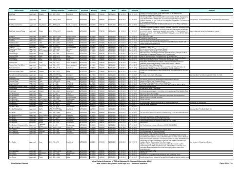
Official Name Name Status Feature Statutory Reference Land District Projection Northing Easting Datum Latitude Longitude Description Comment<br />
Te Whata Approved Stream 1997 (60) p.1403 Southland NZTM2000 4867300 1164400 NZGD2000 46 12 29 S 167 21 10 E<br />
Stream on Southern Coast <strong>of</strong> the South Island in Te Waewae Bay.<br />
Sometimes known as The Whata<br />
Hill at height 854m, approximately 20km south-east <strong>of</strong> Opotiki. Topographic<br />
Te Whatui Approved Hill 2001 (142) p.3600 Gisborne NZTM2000 5776100 1995500 NZGD2000 38 04 35 S 177 30 30 E<br />
map 260 X16, Motu, GR 056 376. Currently named Te Pakora by <strong>New</strong><br />
Corrigendum: 14/05/2009 66:1498 (amendment to description)<br />
<strong>Zealand</strong> Gazette, 29 July 1948, No. 42, page 939. Trig station “Te Pakora No<br />
2” is located on this hill.<br />
Te Whauotemarama Approved Trig Station 1944 (HON) p.36 South Auckland NZTM2000 5784900 1758100 NZGD2000 38 04 12 S 174 48 09 E<br />
Block IX,Kawhia North SD, SA LD, possibly shown as Te Whau o te Marau<br />
on maps<br />
The main ridgeline <strong>of</strong> Te Motu Kairangi / Miramar Peninsula, extending northsouth<br />
from Mount Crawford in the north to the high point above Worser Bay,<br />
Te Whetū Kairangi Ridge Approved Ridge 2010 (173) p.4271 Wellington NZTM2000 5424200 1752700 NZGD2000 41 19 09 S 174 49 28 E on which is located a beaconed geodetic mark, coded 8117 and named “11<br />
Seatoun”, at height 117m. NZTopo50-BQ31-Wellington, from: GR 531 269 to<br />
GR 527 242.<br />
Assigning a new name for a feature not named.<br />
Te Whiro Approved Trig Station 1974 (100) p.2163 North Auckland NZTM2000 6017100 1691300 NZGD2000 35 59 11 S 174 00 46 E For site <strong>of</strong> Trig. 740<br />
Tea Tree Stream Approved Stream 1987 (62) p.1964 Marlborough NZTM2000 5380000 1649400 NZGD2000 41 43 49 S 173 35 38 E Tributary to the Avon River<br />
Teal Bay Approved Bay 1978 (13) p.422 Southland NZTM2000 4882500 1158800 NZGD2000 46 04 06 S 167 17 41 E The bay at southern shores <strong>of</strong> Lake Hauroko.<br />
Teardrop Lake Approved Lake 1957 (91) p.2304 Southland NZTM2000 4975300 1143800 NZGD2000 45 13 40 S 167 11 19 E<br />
One unnamed river flowing into Precipice Cove <strong>of</strong> Bradshaw Sound. 120<br />
chains north <strong>of</strong> Precipice Cove<br />
Teardrop Stream Approved Stream 1968 (9) p.268 Canterbury NZTM2000 5241400 1556200 NZGD2000 42 58 44 S 172 27 46 E<br />
Teheoriri Approved Trig Station 1943 (HON) p.34 North Auckland NZTM2000 6122600 1676400 NZGD2000 35 02 11 S 173 50 15 E Instead <strong>of</strong> Tehe o Riri<br />
Teichelmann Rock Approved Rock 1935 (HON) p.34 Westland NZTM2000 5187800 1371000 NZGD2000 43 25 40 S 170 10 15 E On the terminal face <strong>of</strong> Franz Josef Glacier<br />
Tekapo B Approved Power Station 1991 (32) p.687 Otago NZTM2000 5110600 1376800 NZGD2000 44 07 25 S 170 12 37 E Power station. Replaces the name 'Pukaki'<br />
Tekoa Range Approved Range 1973 (15) p.365 Canterbury NZTM2000 5277500 1568700 NZGD2000 42 39 16 S 172 37 05 E<br />
Mountain range extending southwards generally from a point just south <strong>of</strong><br />
Shale Peak on the Organ Range to Trig. Charing Cross<br />
Tempest Peak Approved Peak 1940 (HON) p.35 Otago NZTM2000 5077000 1233700 NZGD2000 44 22 04 S 168 24 10 E West <strong>of</strong> Typhoon Peak. The highest point <strong>of</strong> Tempest Spur<br />
Temple Col Approved Col 1943 (HON) p.35 Canterbury NZTM2000 5248700 1484800 NZGD2000 42 54 20 S 171 35 20 E Between Mounts Temple and Blimit, from Mingha into the Temple Basin<br />
Temple Peak Approved Peak 1990 (132) p.2739 Otago NZTM2000 5115100 1339900 NZGD2000 44 04 16 S 169 45 07 E Peak approximately 7,400 ft, 3.5 mile SW <strong>of</strong> Rabbiters Peak<br />
Temple View Approved Town 1958 (73) p.1731 South Auckland NZTM2000 5811700 1796200 NZGD2000 37 49 16 S 175 13 45 E<br />
Adjacent to the Temple and College <strong>of</strong> the Church <strong>of</strong> Jesus Christ <strong>of</strong><br />
Latterday Saints. Approximately 3 miles south-west <strong>of</strong> Frankton<br />
Temple View Post Office Approved Post Office 1958 (73) p.1731 South Auckland NZTM2000 5811900 1796200 NZGD2000 37 49 09 S 175 13 45 E To serve the Town <strong>of</strong> Temple View<br />
Templers Islands Approved Area 2005 (45) p.1115 Canterbury NZTM2000 5188300 1562000 NZGD2000 43 27 26 S 172 31 49 E<br />
Rural area located between the Waimakariri River and the Christchurch<br />
International Airport. Spelling correction from Templars Islands<br />
Ten Hour Gorge Creek Approved Stream 1975 (62) p.1632 Otago NZTM2000 5080700 1239900 NZGD2000 44 20 15 S 168 28 59 E<br />
Flows from Remote Peaks to the Arawata River near the mouth <strong>of</strong> Ten Hour<br />
Gorge<br />
Ten Mile Creek/Waianiwaniwa Approved Creek<br />
Ngāi Tahu Claims<br />
Settlement Act 1998<br />
Westland NZTM2000 5311500 1456700 NZGD2000 42 20 08 S 171 15 38 E For creek 6 kms north <strong>of</strong> Runanga Alteration from Ten Mile Creek (8/07/1982 76:2163)<br />
Tent Gully Approved Valley 1968 (9) p.268 Canterbury NZTM2000 5233500 1532000 NZGD2000 43 02 53 S 172 09 54 E<br />
Teparapara Bay Approved Bay 1976 (110) p.2453 North Auckland NZTM2000 6085900 1723400 NZGD2000 35 21 45 S 174 21 30 E For the bay just north <strong>of</strong> Rocky Point in Whangaruru Harbour.<br />
Terminal Peak Approved Peak 1938 (HON) p.35 Otago NZTM2000 5062100 1225500 NZGD2000 44 29 50 S 168 17 22 E Above the Olivine and Forgotten Rivers<br />
Terminus Creek Approved Stream 1967 (4) p.120 Southland NZTM2000 5016600 1185800 NZGD2000 44 53 00 S 167 45 19 E Tributary <strong>of</strong> Worsley Stream, west <strong>of</strong> Castle River<br />
Tertiary Creek Approved Stream 1967 (4) p.120 Southland NZTM2000 4994400 1184800 NZGD2000 45 04 55 S 167 43 28 E Flows into North Fiord, Lake Te Anau, from the vicinity <strong>of</strong> Halfway Peak<br />
Teschemaker School Corner Approved Corner 1982 (76) p.2163 Canterbury NZTM2000 5061300 1440000 NZGD2000 44 35 02 S 170 59 04 E Historically known corner<br />
Teviot Island Approved Island 1935 (HON) p.36 Otago NZTM2000 4950500 1312600 NZGD2000 45 32 23 S 169 19 07 E At the mouth <strong>of</strong> the Teviot River<br />
Thar Creek Approved Stream 1995 (69) p.1847 Canterbury NZTM2000 5128100 1345200 NZGD2000 43 57 22 S 169 49 28 E A tribtuary approximately 2.5 km long, on the west side <strong>of</strong> the Hopkins River<br />
The Anchorage Approved Bay 1984 (1) p.24 Nelson NZTM2000 5466300 1604900 NZGD2000 40 57 16 S 173 03 30 E Name for inlet in Torrent Bay<br />
The Apprentice Approved Peak 1996 (94) p.2470 Canterbury NZTM2000 5305300 1545400 NZGD2000 42 24 10 S 172 20 11 E Peak (1678m) south west <strong>of</strong> Lewis Pass, adjacent to Mount Technical<br />
The Arches Approved Cliff 1982 (76) p.2163 North Auckland NZTM2000 5948226 1769306 NZGD2000 36 35 47 S 174 53 34 E Name <strong>of</strong> semicircular cliff formation<br />
The Barracks Approved Rock Feature 1974 (11) p.233 Marlborough NZTM2000 5330800 1623200 NZGD2000 42 10 29 S 173 16 51 E Rocky outcrops<br />
The Bends Pool Approved River Feature 1987 (163) p.4458 Wellington NZTM2000 5683070 1842490 NZGD2000 38 58 04 S 175 47 56 E<br />
The Big D Approved Island 1967 (4) p.120 Taranaki NZTM2000 5673700 1696200 NZGD2000 39 04 50 S 174 06 44 E A large island in the Waiwhakaiho River. North-east Egmont Position to be determined<br />
The Big Rock Approved Rock 1989 (62) p.1435 Otago NZTM2000 4908530 1393610 NZGD2000 45 56 45 S 170 20 14 E Rock on coast at Brighton<br />
The Black Spur Approved Ridge 1974 (11) p.233 Marlborough NZTM2000 5338500 1641400 NZGD2000 42 06 16 S 173 30 03 E<br />
The Bluff/Motupōhue Approved Bluffs<br />
Ngāi Tahu Claims<br />
Settlement Act 1998<br />
Southland NZTM2000 4827000 1243000 NZGD2000 46 36 56 S 168 20 14 E Alteration from The Bluff (Bluff Hill)<br />
The Bluffs Approved Cliff 1964 (79) p.2365 Nelson NZTM2000 5478700 1668600 NZGD2000 40 50 24 S 173 48 49 E On east shore <strong>of</strong> Greville Harbour, between Trigs. "Tub" and "North Boulder"<br />
The Boulevard Pool Approved River Feature 1987 (163) p.4458 Wellington NZTM2000 5679020 1843620 NZGD2000 39 00 14 S 175 48 48 E<br />
The Braes Approved Range 1964 (79) p.2365 Canterbury NZTM2000 5263300 1557600 NZGD2000 42 46 54 S 172 28 54 E The north-west slopes <strong>of</strong> "The Roderick Peak"<br />
The Bridge Approved Ridge 1968 (9) p.268 Marlborough NZTM2000 5367300 1678200 NZGD2000 41 50 32 S 173 56 31 E The ridge between Peggioh and Blue Mountain<br />
The Brothers Approved Island 1988 (93) p.2239 Southland NZTM2000 4759700 1204400 NZGD2000 47 11 49 S 167 46 36 E Small islands previously marked on maps as The Sisters<br />
The Brothers Approved Ridge 1970 (10) p.297 Canterbury NZTM2000 5158000 1468200 NZGD2000 43 43 10 S 171 21 50 E Hill Feature<br />
The Brothers Telegraph Office Approved<br />
Telegraph<br />
Office<br />
1950 (4) p.39 Marlborough NZTM2000 5399400 1646900 NZGD2000 41 33 21 S 173 33 45 E On The Brothers. Instead <strong>of</strong> Brothers (31/03/1949 22:858)<br />
The Bypass Pool Approved River Feature 1987 (163) p.4458 Wellington NZTM2000 5676130 1843560 NZGD2000 39 01 48 S 175 48 49 E<br />
The Castles Approved Ridge 1974 (11) p.233 Marlborough NZTM2000 5385500 1663400 NZGD2000 41 40 47 S 173 45 42 E Ridge between the branches <strong>of</strong> the Omaka River<br />
The Cataracts Approved Waterfall 1973 (15) p.365 Taranaki NZTM2000 5653800 1688100 NZGD2000 39 15 38 S 174 01 16 E For the waterfalls on "Cataract Stream"<br />
The Cathedrals Approved Rock 1975 (62) p.1632 Canterbury NZTM2000 5253200 1624600 NZGD2000 42 52 24 S 173 18 04 E Rock feature in the vicinity <strong>of</strong> Gore Bay<br />
South-eastern extremity <strong>of</strong> the South Island. Defined generally as being<br />
bounded by the coastline from Clutha River/Mata-Au in the north to Mataura<br />
River at Fortrose in the south. The inland boundary includes headwaters and<br />
catchments <strong>of</strong> rivers and streams in the area that flows to the coast, and<br />
The Catlins Approved Area 2010 (10) p.313 Southland NZTM2000 4850000 1315000 NZGD2000 46 26 36 S 169 17 22 E includes Catlins Conservation Park. See map at<br />
http://www.linz.govt.nz/placenames/consultation-decisions/a-to-z/thecatlins/images/boundary-map/index.aspx.<br />
“The Catlins” is a locally used<br />
recorded name now formalised as the <strong>of</strong>ficial geographic name with a<br />
bounded extent.<br />
The Causeway Approved Cliff 1994 (133) p.4349 Taranaki NZTM2000 5652000 1693000 NZGD2000 39 16 35 S 174 04 42 E Below Dieffenbach Cliffs<br />
The Caves Approved Hill Feature 1974 (11) p.233 Marlborough NZTM2000 5317200 1625300 NZGD2000 42 17 49 S 173 18 25 E Hill feature<br />
The Chasm Approved Bay 1987 (62) p.1964 Otago NZTM2000 4915100 1420100 NZGD2000 45 53 39 S 170 40 52 E Small bay on Otago Peninsula. Positional shift <strong>of</strong> existing name<br />
The Clump Approved Trees 1987 (62) p.1964 Otago NZTM2000 4929300 1405600 NZGD2000 45 45 45 S 170 30 00 E Small clump <strong>of</strong> trees at head <strong>of</strong> Semple Burn. Positional shift <strong>of</strong> existing name<br />
<strong>New</strong> <strong>Zealand</strong> <strong>Names</strong><br />
Also located in Otago Land District<br />
<strong>New</strong> <strong>Zealand</strong> <strong>Gazetteer</strong> <strong>of</strong> Official Geographic <strong>Names</strong> (8 <strong>November</strong> <strong>2011</strong>)<br />
<strong>New</strong> <strong>Zealand</strong> Geographic Board Ngā Pou Taunaha o Aotearoa Page 103 <strong>of</strong> 120


