Gazetteer of New Zealand Names - 3 November 2011
Gazetteer of New Zealand Names - 3 November 2011
Gazetteer of New Zealand Names - 3 November 2011
Create successful ePaper yourself
Turn your PDF publications into a flip-book with our unique Google optimized e-Paper software.
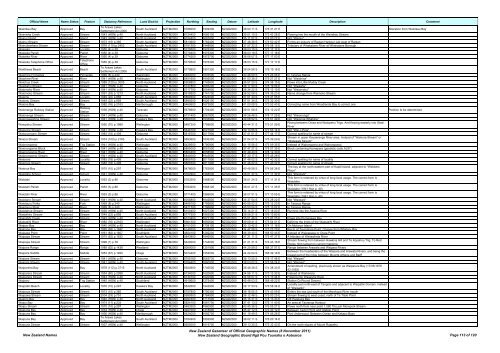
Official Name Name Status Feature Statutory Reference Land District Projection Northing Easting Datum Latitude Longitude Description Comment<br />
Wainīkau Bay Approved Bay<br />
Te Arawa Lakes<br />
Settlement Act 2006<br />
South Auckland NZTM2000 5788000 1909300 NZGD2000 38 00 11 S 176 31 21 E Alteration from Wainikau Bay<br />
Wainiwha Creek Approved Stream 1943 (HON) p.40 North Auckland NZTM2000 6124400 1666100 NZGD2000 35 01 15 S 173 43 28 E Flowing into the mouth <strong>of</strong> the Wairakau Stream<br />
Wainui Island Approved Island 1943 (HON) p.40 North Auckland NZTM2000 6104400 1691600 NZGD2000 35 11 57 S 174 00 22 E Not "Wainiu"<br />
Wainui Stream Approved Stream 1973 (15) p.365 South Auckland NZTM2000 5813600 1762400 NZGD2000 37 48 38 S 174 50 42 E Forms an estuary <strong>of</strong> Raglan Harbour just west <strong>of</strong> Raglan<br />
Wainuitewhara Stream Approved Stream 1976 (110) p.2453 South Auckland NZTM2000 5791300 1948900 NZGD2000 37 57 32 S 176 58 15 E Tributary <strong>of</strong> Whakatane River at Whakatane Borough<br />
Waioeka Approved Locality 1950 (4) p.39 Gisborne NZTM2000 5779500 1976300 NZGD2000 38 03 15 S 177 17 17 E<br />
Waioeka Parish Approved Parish 1950 (4) p.39 Gisborne NZTM2000 5779400 1976300 NZGD2000 38 03 18 S 177 17 18 E<br />
Waioeka River Approved River 1950 (4) p.39 Gisborne NZTM2000 5774200 1975700 NZGD2000 38 06 07 S 177 17 03 E<br />
Waioeka Telephone Office Approved<br />
Telephone<br />
Office<br />
1950 (4) p.39 Gisborne NZTM2000 5779500 1976300 NZGD2000 38 03 15 S 177 17 17 E<br />
Waiōhewa Beach Approved Beach<br />
Te Arawa Lakes<br />
Settlement Act 2006<br />
South Auckland NZTM2000 5779800 1891300 NZGD2000 38 04 58 S 176 19 16 E<br />
Waiohine Pinnacles Approved Pinnacles 1969 (8) p.240 Wellington NZTM2000 5484000 1805500 NZGD2000 40 46 09 S 175 26 06 E In Tararua Range<br />
Waiohine River Approved River 1941 (HON) p.40 Wellington NZTM2000 5451600 1806500 NZGD2000 41 03 38 S 175 27 27 E Not "Waiohina"<br />
Waiohua Creek Approved Stream 1989 (120) p.3005 North Auckland NZTM2000 5908800 1745800 NZGD2000 36 57 20 S 174 38 15 E Flows into Little Muddy Creek<br />
Waiokahu Stream Approved Stream 1941 (HON) p.40 Gisborne NZTM2000 5747800 2065200 NZGD2000 38 17 50 S 178 19 06 E Not "Waikahu"<br />
Waiomoko River Approved River 1941 (HON) p.40 Gisborne NZTM2000 5717700 2054800 NZGD2000 38 34 22 S 178 13 10 E Not "Waiomoku"<br />
Waiomoko Stream Approved Stream 1991 (53) p.1213 North Auckland NZTM2000 5918500 1741700 NZGD2000 36 52 08 S 174 35 23 E Name change from Waimoko Stream<br />
Waiomu Approved Locality 1949 (22) p.858 South Auckland NZTM2000 5899300 1824000 NZGD2000 37 01 33 S 175 31 05 E<br />
Waiomu Stream Approved Stream 1949 (22) p.858 South Auckland NZTM2000 5899200 1826100 NZGD2000 37 01 34 S 175 32 30 E<br />
Waiona Bay Approved Bay 1982 (76) p.2163 Marlborough NZTM2000 5460600 1673900 NZGD2000 41 00 09 S 173 52 43 E Correcting name from Woodlands Bay to correct one<br />
Waionanga Railway Station Approved<br />
Railway<br />
Station<br />
1938 (HON) p.40 Taranaki NZTM2000 5678900 1704400 NZGD2000 39 01 58 S 174 12 22 E Position to be determined<br />
Waionanga Stream Approved Stream 1941 (HON) p.40 Gisborne NZTM2000 5731400 2061800 NZGD2000 38 26 46 S 178 17 25 E Not "Waiononga"<br />
Waiongawahine Stream Approved Stream 1941 (HON) p.40 Hawke's Bay NZTM2000 5659700 1933900 NZGD2000 39 08 52 S 176 51 49 E Not "Waionga Whahine"<br />
Waiopehu Stream Approved Stream 1950 (70) p.1989 Wellington NZTM2000 5487200 1799800 NZGD2000 40 44 31 S 175 21 59 E<br />
Rising between Oriwa and Waiopehu Trigs. And flowing easterly into Otaki<br />
River<br />
Waiopine Stream Approved Stream 1941 (HON) p.40 Hawke's Bay NZTM2000 5646100 2021900 NZGD2000 39 13 55 S 177 53 14 E Not "Wai o Pina"<br />
Waiopuoroaro Stream Approved Stream 1983 (18) p.409 Gisborne NZTM2000 5818700 2017900 NZGD2000 37 41 01 S 177 44 17 E Correct spelling for name <strong>of</strong> stream<br />
Waiora Stream Approved Stream 1974 (100) p.2163 South Auckland NZTM2000 5893600 1836300 NZGD2000 37 04 27 S 175 39 29 E<br />
Stream in upper Kauaeranga River area. Instead <strong>of</strong> "Wainora Stream" or<br />
"Waiwawa Stream"<br />
Waiorongomai Approved Trig Station 1941 (HON) p.40 Wellington NZTM2000 5429500 1780900 NZGD2000 41 15 56 S 175 09 35 E Instead <strong>of</strong> Wairongoma and Wairongomai<br />
Waiorongomai Block Approved Block 1941 (HON) p.40 Gisborne NZTM2000 5805000 2051500 NZGD2000 37 47 27 S 178 07 35 E Block containing Komapara (geodetic code AL97)<br />
Waiorongomai River Approved River 1941 (HON) p.40 Gisborne NZTM2000 5800400 2058500 NZGD2000 37 49 43 S 178 12 30 E<br />
Waiorongomai Stream Approved Stream 1941 (HON) p.40 South Auckland NZTM2000 5840000 1843600 NZGD2000 37 33 17 S 175 45 28 E<br />
Waiorore Approved Locality 1983 (18) p.409 Gisborne NZTM2000 5809700 <strong>2011</strong>900 NZGD2000 37 46 02 S 177 40 32 E Correct spelling for name <strong>of</strong> locality<br />
Waiorore Stream Approved Stream 1983 (18) p.409 Gisborne NZTM2000 5809700 <strong>2011</strong>900 NZGD2000 37 46 02 S 177 40 32 E Correct spelling for name <strong>of</strong> stream<br />
Waiorua Bay Approved Bay 1970 (10) p.297 Wellington NZTM2000 5478000 1763900 NZGD2000 40 49 58 S 174 56 38 E<br />
The bay at the north-eastern part <strong>of</strong> Kapiti Island, adjacent to "Webbers<br />
Place"<br />
Waiotahe School Approved School 1941 (HON) p.40 Gisborne NZTM2000 5782900 1968000 NZGD2000 38 01 37 S 177 11 32 E Not "Waiotahi"<br />
Waiotahi Approved Locality 1953 (3) p.86 Gisborne NZTM2000 5783300 1968000 NZGD2000 38 01 24 S 177 11 31 E<br />
This form is retained by virtue <strong>of</strong> long local usage. The correct form is<br />
Waiotahe<br />
Waiotahi Parish Approved Parish 1953 (3) p.86 Gisborne NZTM2000 5783200 1968100 NZGD2000 38 01 27 S 177 11 35 E<br />
This form is retained by virtue <strong>of</strong> long local usage. The correct form is<br />
Waiotahe (1941 Hon p. 40)<br />
Waiotahi River Approved River 1953 (3) p.86 Gisborne NZTM2000 5771400 1966600 NZGD2000 38 07 51 S 177 10 55 E<br />
This form is retained by virtue <strong>of</strong> long local usage. The correct form is<br />
Waiotahe (1941 Hon p. 40)<br />
Waiotane Stream Approved Stream 1941 (HON) p.40 North Auckland NZTM2000 6056800 1642800 NZGD2000 35 37 54 S 173 28 22 E Not "Waiotani"<br />
Waiotauru Forks Approved Fork 1969 (8) p.240 Wellington NZTM2000 5468100 1785800 NZGD2000 40 55 02 S 175 12 23 E In Tararua Range<br />
Waiotauru River Approved River 1969 (8) p.240 Wellington NZTM2000 5471700 1786800 NZGD2000 40 53 04 S 175 13 02 E In Tararua Range<br />
Waiotehue Stream Approved Stream 1936 (HON) p.40 North Auckland NZTM2000 6100400 1627300 NZGD2000 35 14 21 S 173 18 00 E Running into the Awaroa River<br />
Waiowhiro Stream Approved Stream 1949 (22) p.858 South Auckland NZTM2000 5777500 1883500 NZGD2000 38 06 21 S 176 13 60 E<br />
Waipahihi Creek Approved Stream 1943 (HON) p.40 North Auckland NZTM2000 6123400 1672100 NZGD2000 35 01 46 S 173 47 25 E Flows into Pumanawa Bay<br />
Waipakihi River Approved River 1982 (76) p.2163 Wellington NZTM2000 5661300 1850600 NZGD2000 39 09 41 S 175 54 01 E Defining the limits <strong>of</strong> the Waipakihi River<br />
Waipao Bay Approved Bay 1940 (HON) p.40 North Auckland NZTM2000 6101000 1708100 NZGD2000 35 13 42 S 174 11 16 E On Moturua Island<br />
Waipapa Bay Approved Bay 1995 (69) p.1847 North Auckland NZTM2000 6149200 1635800 NZGD2000 34 47 56 S 173 23 29 E Bay E <strong>of</strong> Taumatara Point. Change from Whataru Bay<br />
Waipapa Point Approved Point 1951 (82) p.1607 Southland NZTM2000 4824100 1282200 NZGD2000 46 39 40 S 168 50 45 E Instead <strong>of</strong> Waipapapa or Otara Point<br />
Waipapa Stream Approved Stream 1975 (62) p.1632 South Auckland NZTM2000 5843800 1846900 NZGD2000 37 31 11 S 175 47 37 E A tributary <strong>of</strong> Waitawheta River<br />
Waipapa Stream Approved Stream 1998 (1) p.78 Wellington NZTM2000 5420000 1744000 NZGD2000 41 21 31 S 174 43 18 E<br />
Stream flowing from between Hawkins Hill and Te Kopahou Trig. To Red<br />
Rocks. Not named on current mapping<br />
Waipara Range Approved Range 1989 (62) p.1438 Westland NZTM2000 5080000 1251900 NZGD2000 44 20 59 S 168 37 57 E Range between Arawata and Waipara Rivers<br />
Waipara Saddle Approved Saddle 1953 (67) p.1920 Otago NZTM2000 5074400 1254000 NZGD2000 44 24 04 S 168 39 18 E<br />
Between the headwaters <strong>of</strong> the Waipara and Arawata Rivers, and being the<br />
lowest part <strong>of</strong> the ridge between Mounts Athene and Barff<br />
Waipare Stream Approved Stream 1941 (HON) p.40 Gisborne NZTM2000 5755160 2063730 NZGD2000 38 13 55 S 178 17 48 E Not "Waipari"<br />
Waipare Stream Approved Stream 1941 (HON) p.40 South Auckland NZTM2000 5784400 1860900 NZGD2000 38 03 02 S 175 58 24 E Not "Waipari"<br />
Waipareira Bay Approved Bay 1979 (112) p.3715 North Auckland NZTM2000 5924900 1746500 NZGD2000 36 48 38 S 174 38 33 E<br />
Amendment <strong>of</strong> spelling, previously shown as Waiparera Bay (17/05/1979<br />
42:1553)<br />
Waiparera Stream Approved Stream 1954 (80) p.2088 North Auckland NZTM2000 6134000 1620600 NZGD2000 34 56 11 S 173 13 32 E Instead <strong>of</strong> Waiharera<br />
Waiparera Stream Approved Stream 1943 (HON) p.40 North Auckland NZTM2000 6134100 1620900 NZGD2000 34 56 07 S 173 13 44 E Flowing into Waiaruhe River<br />
Waiparu Approved Trig Station 1945 (HON) p.40 Southland NZTM2000 4919600 1275400 NZGD2000 45 48 03 S 168 49 22 E Station Q (Round Downs)<br />
Waipatiki Beach Approved Locality 1970 (10) p.297 Hawke's Bay NZTM2000 5642600 1942900 NZGD2000 39 17 53 S 176 58 34 E<br />
Locality just north-east <strong>of</strong> Tangoio and adjacent to Waipatiki Domain. Instead<br />
<strong>of</strong> "Waipatiki"<br />
Waipaua Stream Approved Stream 1973 (15) p.365 South Auckland NZTM2000 5757800 1750300 NZGD2000 38 18 55 S 174 43 09 E Enters the sea just south <strong>of</strong> the Marokopa River mouth<br />
Waipawa Stream Approved Stream 2004 (33) p.751 North Auckland NZTM2000 5990500 1784900 NZGD2000 36 12 46 S 175 03 25 E Stream flowing to west coast, north <strong>of</strong> Te Titoki Point<br />
Waipiro Bay Approved Bay 1940 (HON) p.40 North Auckland NZTM2000 6097600 1711500 NZGD2000 35 15 31 S 174 13 33 E Off Parekura Bay<br />
Waipu Bay Approved Bay 1974 (11) p.233 South Auckland NZTM2000 5824100 1881700 NZGD2000 37 41 13 S 176 11 40 E An area at Tauranga Harbour<br />
Waipu Stream Approved Stream 1970 (10) p.297 Wellington NZTM2000 5483300 1860900 NZGD2000 40 45 36 S 176 05 27 E Flows north from near point 1,080 ft to join Morepork Stream<br />
Waipuna Bay Approved Bay 1934 (HON) p.40 Otago NZTM2000 4927000 1418900 NZGD2000 45 47 12 S 170 40 12 E Between Taylor Point and Otafelo Point<br />
Waipuna Bay Approved Bay 1936 (HON) p.40 Marlborough NZTM2000 5424000 1692700 NZGD2000 41 19 49 S 174 06 28 E Port Underwood. Between Ocean and Kakapo Bays<br />
Waipuna Bay Approved Bay<br />
Te Arawa Lakes<br />
Settlement Act 2006<br />
South Auckland NZTM2000 5784900 1892900 NZGD2000 38 02 11 S 176 20 14 E<br />
Waipuna Stream Approved Stream 1937 (HON) p.40 Wellington NZTM2000 5655000 1819700 NZGD2000 39 13 35 S 175 32 43 E On the north slopes <strong>of</strong> Mount Ruapehu<br />
<strong>New</strong> <strong>Zealand</strong> <strong>Names</strong><br />
<strong>New</strong> <strong>Zealand</strong> <strong>Gazetteer</strong> <strong>of</strong> Official Geographic <strong>Names</strong> (8 <strong>November</strong> <strong>2011</strong>)<br />
<strong>New</strong> <strong>Zealand</strong> Geographic Board Ngā Pou Taunaha o Aotearoa Page 113 <strong>of</strong> 120


