

Gazetteer of New Zealand Names - 3 November 2011
Gazetteer of New Zealand Names - 3 November 2011
Gazetteer of New Zealand Names - 3 November 2011

You also want an ePaper? Increase the reach of your titles
YUMPU automatically turns print PDFs into web optimized ePapers that Google loves.
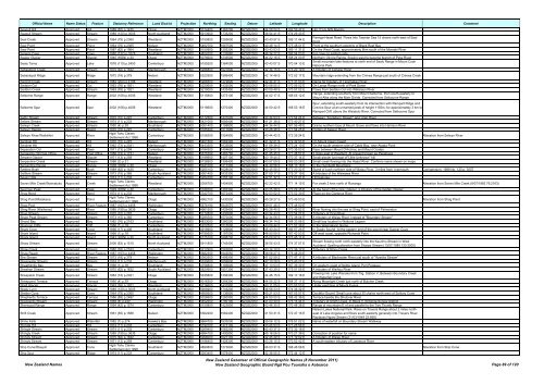
Official Name Name Status Feature Statutory Reference Land District Projection Northing Easting Datum Latitude Longitude Description Comment<br />
Seagull Hill Approved Hill 1989 (62) p.1435 Otago NZTM2000 5014400 1363200 NZGD2000 44 59 04 S 169 59 47 E Hill 12 km NW Naesby<br />
Seagull Stream Approved Stream 1989 (120) p.3005 North Auckland NZTM2000 5913900 1733200 NZGD2000 36 54 41 S 174 29 43 E<br />
Seal Creek Approved Stream 1964 (79) p.2365 Westland NZTM2000 5150800 1293600 NZGD2000 43 43 57 S 169 11 44 E<br />
Paringa-Haast Road. Flows into Tasman Sea 15 chains north-east <strong>of</strong> Seal<br />
Point<br />
Seal Point Approved Point 1964 (79) p.2365 Nelson NZTM2000 5482700 1667500 NZGD2000 40 48 14 S 173 48 01 E Point at the southern extemity <strong>of</strong> Black Reef Bay<br />
Seal Point Approved Point 1987 (62) p.1964 Westland NZTM2000 5150900 1293300 NZGD2000 43 43 53 S 169 11 31 E On the West Coast, approximately 6km south <strong>of</strong> the Moeraki River<br />
Sealers Cave Approved Cave 1980 (132) p.3278 Southland NZTM2000 4824200 1132680 NZGD2000 46 34 22 S 166 54 03 E For cave on eastern side<br />
Sealey Glacier Approved Glacier 1940 (HON) p.30 Otago NZTM2000 5076600 1233500 NZGD2000 44 22 16 S 168 24 00 E Northern Olivine Range, flowing west to become branch <strong>of</strong> Pyke River<br />
Sealy Tarns Approved Lake 1976 (110) p.2453 Canterbury NZTM2000 5155200 1364000 NZGD2000 43 43 07 S 170 04 13 E<br />
Small mountain lake features at north end <strong>of</strong> Sealy Range in Mount Cook<br />
National Park.<br />
Sebastopol Creek Approved Stream 1975 (62) p.1632 Marlborough NZTM2000 5286800 1627800 NZGD2000 42 34 15 S 173 20 19 E A tributary <strong>of</strong> Conway River<br />
Sebastopol Ridge Approved Ridge 1972 (18) p.379 Nelson NZTM2000 5322900 1589400 NZGD2000 42 14 46 S 172 52 17 E Mountain ridge extending from the Crimea Range just south <strong>of</strong> Crimea Creek<br />
Second Creek Approved Stream 1984 (204) p.4798 Westland NZTM2000 5266500 1479800 NZGD2000 42 44 41 S 171 31 53 E Name for tributary <strong>of</strong> Taramakau River<br />
Seddon Col Approved Col 1963 (76) p.1921 Westland NZTM2000 5220600 1432000 NZGD2000 43 08 55 S 170 56 02 E On Lange Range north <strong>of</strong> Park Dome<br />
Seddon Creek Approved Stream 1963 (76) p.1921 Westland NZTM2000 5219000 1433400 NZGD2000 43 09 48 S 170 57 02 E Flows from Seddon Col into Wilkinson River<br />
Selborne Range Approved Range 2002 (158) p.4006 Westland NZTM2000 5115800 1273100 NZGD2000 44 02 17 S 168 55 12 E<br />
Range, extending southerly from Mount Selborne, then south-easterly to<br />
Mount Alba along the Main Divide. Corrected from Selbourne Range<br />
Selborne Spur Approved Spur 2002 (158) p.4006 Westland NZTM2000 5118600 1270400 NZGD2000 44 00 42 S 168 53 18 E<br />
Spur, extending south-westerly from its intersection with Rampart Ridge and<br />
Crevice Spur at an unnamed peak <strong>of</strong> height 1155m, for approximately 3 km to<br />
Rampart Cliff, above the Waiatoto River. Corrected from Selbourne Spur<br />
Selby Stream Approved Stream 1970 (10) p.297 Canterbury NZTM2000 5172500 1431000 NZGD2000 43 34 53 S 170 54 24 E Between "Scotsburn Stream" and Orari River<br />
Sellars Stream Approved Stream 1974 (11) p.233 Marlborough NZTM2000 5421000 1656400 NZGD2000 41 21 38 S 173 40 27 E<br />
Selwyn Creek Approved Stream 1950 (4) p.39 Southland NZTM2000 5051400 1198800 NZGD2000 44 34 44 S 167 56 48 E Drains northern face <strong>of</strong> Mount Grave and flows into Harrison River<br />
Selwyn Rapids Approved Rapid 1970 (10) p.297 Canterbury NZTM2000 5185300 1511600 NZGD2000 43 28 48 S 171 54 25 E Portion <strong>of</strong> Selwyn River<br />
Selwyn River/Waikirikiri Approved River<br />
Ngāi Tahu Claims<br />
Settlement Act 1998<br />
Canterbury NZTM2000 5156300 1554900 NZGD2000 43 44 42 S 172 26 24 E Alteration from Selwyn River<br />
Sentinel Hill Approved Hill 1970 (10) p.297 Nelson NZTM2000 5401300 1562300 NZGD2000 41 32 21 S 172 32 53 E On Mount Owen massif<br />
Sentinel Hill Approved Hill 1962 (73) p.2021 Marlborough NZTM2000 5443300 1633800 NZGD2000 41 09 39 S 173 24 10 E On the south-western side <strong>of</strong> Cable Bay, near Ataata Point<br />
Separation Col Approved Pass 1971 (13) p.259 Canterbury NZTM2000 5184300 1404600 NZGD2000 43 28 07 S 170 35 03 E Pass between Mount D'Archiac and Mount Coates<br />
Sergeants Hill Post Office Approved Post Office 1958 (73) p.1731 Nelson NZTM2000 5375700 1487700 NZGD2000 41 45 45 S 171 38 57 E 2 miles east <strong>of</strong> Westport. At present known as Papahaoa<br />
Serpent Glacier Approved Glacier 1971 (13) p.259 Westland NZTM2000 5199900 1407100 NZGD2000 43 19 44 S 170 37 14 E Small glacier just east <strong>of</strong>"Little Unknown" hill<br />
Serpentine Creek Approved Stream 1988 (2) p.31 Westland NZTM2000 5126900 1306400 NZGD2000 43 57 09 S 169 20 28 E Small creek flowing into the Haast River. Confirms name shown on maps<br />
Serpentine Range Approved Range 1938 (HON) p.30 Otago NZTM2000 5041000 1217300 NZGD2000 44 40 56 S 168 10 16 E In the Humboldt Mountains<br />
Settlers Bush Approved Bush 1989 (62) p.1435 Canterbury NZTM2000 5265100 1628000 NZGD2000 42 45 58 S 173 20 32 E Stand <strong>of</strong> bush northern side <strong>of</strong> Waiau River, 3 miles from rivermouth Corrigendum: 1989 No. 120 p. 3007<br />
Settlers Stream Approved Stream 1973 (15) p.365 South Auckland NZTM2000 5901400 1833300 NZGD2000 37 00 17 S 175 37 19 E A tributary <strong>of</strong> the Waiwawa River<br />
Seven Hills Approved Hill 1974 (11) p.233 Canterbury NZTM2000 5254700 1555100 NZGD2000 42 51 32 S 172 27 01 E Hill features<br />
Seven Mile Creek/Waimatuku Approved Creek<br />
Ngāi Tahu Claims<br />
Settlement Act 1998<br />
Westland NZTM2000 5306700 1454900 NZGD2000 42 22 42 S 171 14 15 E For creek 2 kms north <strong>of</strong> Runanga Alteration from Seven Mile Creek (8/07/1982 76:2163)<br />
Seymour Peak Approved Peak 1929 (HON) p.30 Canterbury NZTM2000 5188700 1397300 NZGD2000 43 25 38 S 170 29 45 E At the head <strong>of</strong> the Grey Glacier, a tributary <strong>of</strong> the Godley Glacier<br />
Shag Bend Approved Bend 1974 (11) p.233 Marlborough NZTM2000 5342700 1672400 NZGD2000 42 03 52 S 173 52 30 E Place on the Clarence River<br />
Shag Point/Matakaea Approved Point<br />
Ngāi Tahu Claims<br />
Settlement Act 1998<br />
Otago NZTM2000 4962100 1430500 NZGD2000 45 28 27 S 170 49 53 E Alteration from Shag Point<br />
Shag Pool Approved River Feature 1987 (163) p.4458 Wellington NZTM2000 5676190 1843570 NZGD2000 39 01 46 S 175 48 50 E<br />
Shag River (Waihemo) Approved River 1985 (155) p.3635 Otago NZTM2000 4961500 1429400 NZGD2000 45 28 45 S 170 49 02 E River flowing into the sea at Shag Point, east <strong>of</strong> Palmerston<br />
Shag Stream Approved Stream 1970 (10) p.297 Canterbury NZTM2000 5172800 1430600 NZGD2000 43 34 43 S 170 54 07 E Tributary <strong>of</strong> Orari River<br />
Shale Peak Stream Approved Stream 1973 (15) p.365 Canterbury NZTM2000 5285500 1570000 NZGD2000 42 34 56 S 172 38 04 E A tributary <strong>of</strong> Waiau River. Instead <strong>of</strong> "Boundary Stream"<br />
Shand Bay Approved Bay 1982 (76) p.2163 Southland NZTM2000 4833000 1260200 NZGD2000 46 34 14 S 168 33 56 E Small bay located in Waituna Lagoon<br />
Shannon Cliffs Approved Cliff 1966 (1) p.18 Canterbury NZTM2000 5222500 1515500 NZGD2000 43 08 44 S 171 57 39 E In the Waimakariri Gorge<br />
Shark Cove Approved Cove 1956 (17) p.406 Southland NZTM2000 4918900 1129800 NZGD2000 45 43 24 S 166 57 26 E In Dusky Sound. At the eastern end <strong>of</strong> the sound near Supper Cove<br />
Shark Island Approved Island 1966 (1) p.18 Southland NZTM2000 4799500 1197000 NZGD2000 46 50 09 S 167 42 53 E Off west coast, opposite Richards Point<br />
Shark Island Approved Island 1943 (HON) p.30 North Auckland NZTM2000 6125100 1668700 NZGD2000 35 00 52 S 173 45 11 E<br />
Sharp Stream Approved Stream 2006 (63) p.1515 North Auckland NZTM2000 5911800 1745400 NZGD2000 36 55 43 S 174 37 57 E<br />
Stream flowing north north-westerly into the Kaurimu Stream in West<br />
Auckland. Spelling alteration from Sharpe Stream (13/07/1989 120:3005)<br />
Shaw Creek Approved Stream 1982 (76) p.2163 Canterbury NZTM2000 5212900 1567800 NZGD2000 43 14 10 S 172 36 12 E Tributary <strong>of</strong> Stony Creek<br />
Shaw Reach Approved River Feature 1987 (163) p.4458 Wellington NZTM2000 5682350 1843050 NZGD2000 38 58 27 S 175 48 20 E<br />
She Stream Approved Stream 1972 (18) p.379 Nelson NZTM2000 5362500 1499300 NZGD2000 41 52 59 S 171 47 11 E A tributary <strong>of</strong> Blackwater River just south <strong>of</strong> "Ayesha Stream"<br />
Shearwater Stream Approved Stream 1974 (11) p.233 Marlborough NZTM2000 5330600 1659800 NZGD2000 42 10 28 S 173 43 27 E<br />
Sheathknife Bay Approved Bay 1966 (1) p.18 Southland NZTM2000 4756800 1195600 NZGD2000 47 13 03 S 167 39 30 E On western coast <strong>of</strong> Noble Island, Port Pegasus<br />
Sheehan Stream Approved Stream 1975 (62) p.1632 South Auckland NZTM2000 5820900 1851300 NZGD2000 37 43 29 S 175 51 05 E A tributary <strong>of</strong> Waihou River<br />
Sheepskin Creek Approved Stream 1962 (73) p.2021 Otago NZTM2000 5035800 1306300 NZGD2000 44 46 15 S 169 17 18 E<br />
Flowing into Lake Wanaka from Trig. Station V. Between Boundary Creek<br />
and Waterfall Creek<br />
Sheepyard Terrace Approved Terrace 1950 (4) p.39 Otago NZTM2000 5016300 1254300 NZGD2000 44 55 22 S 168 37 11 E Along Moonlight Creek just north <strong>of</strong> Butcher Creek<br />
Shelf Glacier Approved Glacier 1963 (76) p.1921 Westland NZTM2000 5216600 1431900 NZGD2000 43 11 05 S 170 55 53 E Under east face <strong>of</strong> Mount Evans<br />
Shelly Lynn Approved Stream 1989 (120) p.3005 North Auckland NZTM2000 5906900 1743200 NZGD2000 36 58 23 S 174 36 32 E<br />
Shelter Cove Approved Cove 1964 (79) p.2365 Southland NZTM2000 4959500 1136800 NZGD2000 45 21 53 S 167 05 07 E Doubtful Sound. Small cove about 30 chains north-west <strong>of</strong> Solitary Cone<br />
Shepherds Terrace Approved Terrace 1986 (89) p.2487 Otago NZTM2000 5026600 1260900 NZGD2000 44 50 00 S 168 42 36 E Terrace beside the Shotover River<br />
Shepperds Stream Approved Stream 1969 (8) p.240 Wellington NZTM2000 5452300 1790100 NZGD2000 41 03 30 S 175 15 44 E Tributary <strong>of</strong> Smith Creek. In Block V, Eritonga Survey District<br />
Sherwood Range Approved Range 1994 (42) p.1574 Canterbury NZTM2000 5150800 1423800 NZGD2000 43 46 30 S 170 48 38 E Range <strong>of</strong> mountains E <strong>of</strong> and parallel to the Two Thumb Range<br />
Nelson Lakes National Park. Rises on Travers Range about 2 miles north-<br />
Shift Creek Approved Stream 1961 (65) p.1586 Nelson NZTM2000 5362200 1582400 NZGD2000 41 53 31 S 172 47 16 E east <strong>of</strong> Lake Angelus and flows south-easterly generally into Travers River.<br />
Replaces Ngaro Stream (31/03/1949 22:858)<br />
Shine Falls Approved Waterfall 1982 (7) p.274 Hawke's Bay NZTM2000 5664700 1933000 NZGD2000 39 06 12 S 176 51 02 E Name <strong>of</strong> waterfall on Boundary Stream Walkway<br />
Shingle Hill Approved Hill 1974 (11) p.233 Canterbury NZTM2000 5190100 1473100 NZGD2000 43 25 53 S 171 25 56 E<br />
Shingle Stream Approved Stream 1974 (11) p.233 Canterbury NZTM2000 5269400 1562200 NZGD2000 42 43 37 S 172 32 18 E<br />
Shingly Creek Approved Stream 1985 (155) p.3635 Otago NZTM2000 4984100 1400800 NZGD2000 45 16 06 S 170 27 38 E Correction <strong>of</strong> position for name<br />
Shingly Stream Approved Stream 1975 (62) p.1632 Canterbury NZTM2000 5266000 1627100 NZGD2000 42 45 29 S 173 19 52 E A tributary <strong>of</strong> Waiau River<br />
Shingly Stream Approved Stream 1971 (13) p.259 Canterbury NZTM2000 5188400 1428300 NZGD2000 43 26 15 S 170 52 42 E A south-eastern tributary <strong>of</strong> Lawrence River<br />
Ship Cone/Ōtaupiri Approved Cone<br />
Ngāi Tahu Claims<br />
Settlement Act 1998<br />
Southland NZTM2000 4890800 1273800 NZGD2000 46 03 31 S 168 46 58 E Alteration from Ship Cone<br />
Ship Spur Approved Ridge 1974 (11) p.233 Canterbury NZTM2000 5283400 1578400 NZGD2000 42 36 05 S 172 44 12 E<br />
<strong>New</strong> <strong>Zealand</strong> <strong>Names</strong><br />
<strong>New</strong> <strong>Zealand</strong> <strong>Gazetteer</strong> <strong>of</strong> Official Geographic <strong>Names</strong> (8 <strong>November</strong> <strong>2011</strong>)<br />
<strong>New</strong> <strong>Zealand</strong> Geographic Board Ngā Pou Taunaha o Aotearoa Page 89 <strong>of</strong> 120


