Gazetteer of New Zealand Names - 3 November 2011
Gazetteer of New Zealand Names - 3 November 2011
Gazetteer of New Zealand Names - 3 November 2011
Create successful ePaper yourself
Turn your PDF publications into a flip-book with our unique Google optimized e-Paper software.
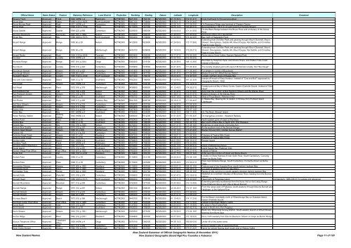
Official Name Name Status Feature Statutory Reference Land District Projection Northing Easting Datum Latitude Longitude Description Comment<br />
Browns Track Approved Track 1944 (HON) p.4 Wellington NZTM2000 5421200 1764100 NZGD2000 41 20 38 S 174 57 41 E From Catchpool to Orongorongo River<br />
Bruce Glen Approved Valley 1989 (120) p.3005 North Auckland NZTM2000 5907100 1735600 NZGD2000 36 58 21 S 174 31 24 E<br />
Bruce Murray Peak Approved Peak 1931 (HON) p.4 Canterbury NZTM2000 5183800 1395200 NZGD2000 43 28 14 S 170 28 05 E On Panorama Ridge near terminal <strong>of</strong> Classen Glacier<br />
Bruce Peak Approved Peak 1990 (132) p.2739 Otago NZTM2000 5113500 1341300 NZGD2000 44 05 10 S 169 46 07 E Approximately 7,100 ft, E <strong>of</strong> north branch <strong>of</strong> Temple Stream<br />
Bruce Saddle Approved Saddle 1949 (22) p.858 Canterbury NZTM2000 5229200 1480500 NZGD2000 43 04 50 S 171 31 55 E<br />
On the Black Range between the Bruce River and a tributary <strong>of</strong> the Avoca<br />
River<br />
Brunner Peninsula Approved Peninsula 1987 (62) p.1964 Nelson NZTM2000 5370300 1586000 NZGD2000 41 49 09 S 172 49 53 E Peninsula jutting into Lake Rotoiti<br />
Bryan Bay Approved Bay 1988 (206) p.5173 North Auckland NZTM2000 5902200 1739600 NZGD2000 37 00 58 S 174 34 09 E Bay north <strong>of</strong> Kaitarakihi Point<br />
Extending from Old Man Peak and passing through Mount Starveall, Mount<br />
Bryant Range Approved Range 1950 (4) p.39 Nelson NZTM2000 5412900 1623800 NZGD2000 41 26 06 S 173 17 06 E Stewart, Maungatapu, Saddle Hill, Mount Duppa, Rai Saddle, and Croisilles<br />
Peak to Cape Soucis<br />
Extending from Old Man Peak and passing through Mount Starveall, Mount<br />
Bryant Range Approved Range 1950 (4) p.39 Marlborough NZTM2000 5435100 1639600 NZGD2000 41 14 04 S 173 28 21 E Stewart, Maungatapu, Saddle Hill, Mount Duppa, Rai Saddle, and Croisilles<br />
Peak to Cape Soucis<br />
Bryant Rocks Approved Rock 1994 (133) p.4349 Taranaki NZTM2000 5650400 1692200 NZGD2000 39 17 27 S 174 04 09 E Rocks above Snow Valley, Egmont National Park<br />
Bryndwr Approved Locality 1938 (HON) p.4 Canterbury NZTM2000 5183100 1566800 NZGD2000 43 30 15 S 172 35 22 E<br />
Bryneira Range Approved Range 1957 (91) p.2304 Otago NZTM2000 5060200 1219100 NZGD2000 44 30 39 S 168 12 28 E<br />
Bounded by Hollyford, Pyke, and Olivine Rivers, and Hidden Falls Creek.<br />
Instead <strong>of</strong> Byrniera<br />
Buccleuch Approved Locality 1978 (13) p.422 Canterbury NZTM2000 5160900 1474500 NZGD2000 43 41 40 S 171 26 34 E The locality situated just north-east <strong>of</strong> Mt.Somers locality. Not "Buccleugh"<br />
Buccleuch Stream Approved Stream 1978 (13) p.422 Canterbury NZTM2000 5161800 1474500 NZGD2000 43 41 10 S 171 26 34 E For stream in vicinity <strong>of</strong> Buccleuch<br />
Buccleugh Stream Approved Stream 1969 (8) p.240 Canterbury NZTM2000 5160800 1471700 NZGD2000 43 41 41 S 171 24 28 E Blocks XI and XII, Alford Survey District<br />
Buckleton Beach Approved Locality 1990 (132) p.2739 North Auckland NZTM2000 5971200 1756700 NZGD2000 36 23 30 S 174 44 50 E Locality northern shore <strong>of</strong> Kawau Bay<br />
Bull and Cow Islands Approved Island 1966 (1) p.18 Southland NZTM2000 4762200 1186400 NZGD2000 47 09 49 S 167 32 33 E<br />
Islands <strong>of</strong>f mouth <strong>of</strong> Easy Harbour. Instead <strong>of</strong> "Cow and Bull" (approved by<br />
Geographic Board, 1962)<br />
Bull Creek Approved Stream 1943 (HON) p.4 Canterbury NZTM2000 5264700 1535700 NZGD2000 42 46 03 S 172 12 51 E<br />
Bull Head Approved Point 1972 (18) p.379 Marlborough NZTM2000 5436900 1696900 NZGD2000 41 12 49 S 174 09 21 E<br />
Coastal point at Bay <strong>of</strong> Many Coves, Queen Charlotte Sound. Instead <strong>of</strong> "East<br />
Head"<br />
Bull Paddock Flat Approved Flat 1972 (18) p.379 Nelson NZTM2000 5373600 1597000 NZGD2000 41 47 22 S 172 57 50 E Area near the junction <strong>of</strong> Bull Paddock Stream and the Wairau River<br />
Bull Paddock Stream Approved Stream 1972 (18) p.379 Nelson NZTM2000 5372400 1596000 NZGD2000 41 48 01 S 172 57 07 E Eastern tributary <strong>of</strong> the Wairau River<br />
Bull Point Approved Point 1966 (1) p.18 Southland NZTM2000 4788100 1226200 NZGD2000 46 57 18 S 168 05 13 E West <strong>of</strong> Paua Beach, Paterson Inlet<br />
Bull Rocks Approved Rock 1956 (17) p.406 Hawke's Bay NZTM2000 5641300 2026700 NZGD2000 39 16 21 S 177 56 44 E<br />
In Hawke Bay. Bearing 62.14 distant, 4.16miles from Portland Island<br />
Lighthouse<br />
Bull Spur Stream Approved Stream 1974 (11) p.233 Canterbury NZTM2000 5206000 1437100 NZGD2000 43 16 52 S 170 59 32 E<br />
Bull Stream Approved Stream 1974 (11) p.233 Canterbury NZTM2000 5264400 1535700 NZGD2000 42 46 13 S 172 12 51 E<br />
Bullen Hills Approved Hill 1974 (11) p.233 Marlborough NZTM2000 5307800 1609900 NZGD2000 42 22 55 S 173 07 13 E<br />
Buller Bay Approved Bay 1941 (HON) p.4 Southland NZTM2000 4792400 1234000 NZGD2000 46 55 15 S 168 11 33 E On The Neck, Stewart Island<br />
Buller Railway Station Approved<br />
Railway<br />
Station<br />
1943 (HON) p.4 Nelson NZTM2000 5365000 1512200 NZGD2000 41 51 43 S 171 56 32 E On Inangahua Junction - Westport Railway<br />
Bullers Point Approved Point 1966 (1) p.18 Southland NZTM2000 4792400 1234100 NZGD2000 46 55 15 S 168 11 38 E North eastern point <strong>of</strong> coast at The Neck<br />
Bulling Bay Approved Bay 1966 (1) p.18 Southland NZTM2000 4760700 1196200 NZGD2000 47 10 59 S 167 40 11 E Bay south <strong>of</strong> Bens Bay in North Arm, Port Pegasus<br />
Bullock Bay Approved Bay 1964 (79) p.2365 Nelson NZTM2000 5476300 1669200 NZGD2000 40 51 41 S 173 49 16 E Small bay on west shore <strong>of</strong> Smulies Arm<br />
Bullock Bow Saddle Approved Saddle 1970 (10) p.297 Canterbury NZTM2000 5157200 1422500 NZGD2000 43 43 01 S 170 47 48 E At the southern end <strong>of</strong> the Sinclair Range<br />
Bullock Head Stream Approved Stream 1968 (9) p.268 Marlborough NZTM2000 5364400 1666000 NZGD2000 41 52 10 S 173 47 43 E Blocks XXI and XXV, Hodder Survey District<br />
Bullock Hill Approved Hill 1974 (11) p.233 Canterbury NZTM2000 5228300 1509000 NZGD2000 43 05 33 S 171 52 55 E<br />
Bullocks Head Creek Approved Stream 1984 (1) p.24 Westland NZTM2000 5297200 1472100 NZGD2000 42 28 01 S 171 26 39 E Tributary <strong>of</strong> Twelve Mile Creek<br />
Bullocks Hide Creek Approved Stream 1984 (1) p.24 Westland NZTM2000 5296900 1472000 NZGD2000 42 28 11 S 171 26 35 E Tributary <strong>of</strong> Twelve Mile Creek<br />
Bunker Islets Approved Island 1941 (HON) p.4 Southland NZTM2000 4798800 1239300 NZGD2000 46 51 59 S 168 16 01 E Stewart Island<br />
Burdans Track Approved Track 1944 (HON) p.4 Wellington NZTM2000 5420700 1758200 NZGD2000 41 20 59 S 174 53 28 E<br />
Burgess Island (Pokohinu) Approved Island 1982 (7) p.274 North Auckland NZTM2000 6024660 1790930 NZGD2000 35 54 13 S 175 06 57 E Island <strong>of</strong> Mokohinau Group<br />
Burial Island Approved Island 1970 (10) p.297 Southland NZTM2000 4794000 1224700 NZGD2000 46 54 05 S 168 04 20 E Island Kaipipi Bay, Paterson Inlet<br />
Buried Village Post Office Approved Post Office 1953 (67) p.1920 South Auckland NZTM2000 5765300 1894300 NZGD2000 38 12 44 S 176 21 41 E Instead <strong>of</strong> Maina<br />
Burke Flat Approved Flat 1990 (191) p.4192 Westland NZTM2000 5119400 1309100 NZGD2000 44 01 15 S 169 22 14 E A flat near the junction <strong>of</strong> Haast and Burke Rivers<br />
Burkes Pass Approved Locality 1998 (1) p.78 Canterbury NZTM2000 5115500 1412100 NZGD2000 44 05 22 S 170 39 10 E<br />
Locality on State Highway 8 near Opihi River, South Canterbury. Currently<br />
shown as Burke Pass<br />
Burkes Pass Approved Pass 1998 (1) p.78 Canterbury NZTM2000 5115200 1407900 NZGD2000 44 05 28 S 170 36 01 E<br />
Pass near Rollesby Range, South Canterbury. Currently shown as Burke<br />
Pass<br />
Burmeister Morass Approved Swamp 1975 (62) p.1632 Westland NZTM2000 5119200 1257000 NZGD2000 44 00 01 S 168 43 19 E Feature east <strong>of</strong> the Arawata River mouth behind Jackson Bay<br />
Burmeister Point Approved Point 1975 (62) p.1632 Westland NZTM2000 5113600 1251300 NZGD2000 44 02 52 S 168 38 51 E For point at western shore <strong>of</strong> Lake Ellery<br />
Burmeister Tops Approved Range 1975 (62) p.1632 Westland NZTM2000 5116900 1251700 NZGD2000 44 01 06 S 168 39 16 E Range <strong>of</strong> hills running in a south easterly direction behind Jackson Bay<br />
Burnett Falls Approved Waterfall 1972 (18) p.379 Canterbury NZTM2000 5165600 1379300 NZGD2000 43 37 47 S 170 15 51 E<br />
Waterfall on a northern tributary <strong>of</strong> Murchison River, leading from the Burnett<br />
Glacier<br />
Burnett Head Approved Headland 1988 (206) p.5173 North Auckland NZTM2000 5898200 1733600 NZGD2000 37 03 11 S 174 30 09 E Head north <strong>of</strong> Paratutae Island Corrigendum: 1988 206:5173 (update grid reference)<br />
Burnett Mountains Approved Mountain 1971 (13) p.259 Canterbury NZTM2000 5152500 1377000 NZGD2000 43 44 49 S 170 13 49 E<br />
Extending generally southwards from the Nuns Veil on the Liebig Range<br />
through Mounts Bruce and Little to Mount Burnett<br />
Burnett Range Approved Range 1970 (10) p.297 Nelson NZTM2000 5501000 1568000 NZGD2000 40 38 28 S 172 37 18 E<br />
From the range west <strong>of</strong> Pakawau, south-westerly through Mounts Burnett and<br />
Haidinger, to the Kaituna River<br />
Burnett Stream Approved Stream 1974 (11) p.233 Canterbury NZTM2000 5085300 1439300 NZGD2000 44 22 04 S 170 58 59 E<br />
Burnett Stream Approved Stream 1968 (9) p.268 Canterbury NZTM2000 5085500 1439100 NZGD2000 44 21 57 S 170 58 50 E<br />
Burneys Beach Approved Beach 1973 (15) p.365 Marlborough NZTM2000 5440700 1708100 NZGD2000 41 10 40 S 174 17 20 E<br />
For the Beach immdiately north <strong>of</strong> Wharehunga Bay on Arapawa Island,<br />
Queen Charlotte Sound.<br />
Burnham Camp Post Office Approved Post Office 1950 (70) p.1989 Canterbury NZTM2000 5171200 1543400 NZGD2000 43 36 36 S 172 17 55 E Instead <strong>of</strong> Burnham Military Camp<br />
Burns Bush Approved Area 1970 (10) p.297 Canterbury NZTM2000 5137600 1458300 NZGD2000 43 54 04 S 171 14 08 E An area in Peel Forest Park<br />
Burnt Island Approved Island 1966 (1) p.18 Southland NZTM2000 4763000 1199000 NZGD2000 47 09 51 S 167 42 31 E Island in North Arm, Port Pegasus<br />
Burnt Stream Approved Stream 1963 (76) p.1921 Marlborough NZTM2000 5355500 1675000 NZGD2000 41 56 56 S 173 54 18 E<br />
Block VIII, Whernside Survey District. South-eastern branch <strong>of</strong> Wharf Stream,<br />
draining from Burnt Spur<br />
Burton Ridge Approved River 1962 (73) p.2021 Westland NZTM2000 5184800 1381600 NZGD2000 43 27 28 S 170 18 02 E Runs north-westerly from Elie de Beamont. Shown on maps as Burton Range<br />
Buscot Telephone Office Approved<br />
Telephone<br />
Office<br />
1938 (HON) p.4 Otago NZTM2000 5075100 1360000 NZGD2000 44 26 15 S 169 59 03 E Under hill <strong>of</strong> the same name<br />
Bush Basin Approved Area 1971 (13) p.259 Canterbury NZTM2000 5191200 1429200 NZGD2000 43 24 45 S 170 53 25 E Area on western side <strong>of</strong> Lawrence River<br />
Bush Camp Stream Approved Stream 1982 (76) p.2163 Marlborough NZTM2000 5378900 1601900 NZGD2000 41 44 30 S 173 01 22 E Name for stream flowing down south side <strong>of</strong> Wairau Valley<br />
<strong>New</strong> <strong>Zealand</strong> <strong>Names</strong><br />
<strong>New</strong> <strong>Zealand</strong> <strong>Gazetteer</strong> <strong>of</strong> Official Geographic <strong>Names</strong> (8 <strong>November</strong> <strong>2011</strong>)<br />
<strong>New</strong> <strong>Zealand</strong> Geographic Board Ngā Pou Taunaha o Aotearoa Page 11 <strong>of</strong> 120


