

Gazetteer of New Zealand Names - 3 November 2011
Gazetteer of New Zealand Names - 3 November 2011
Gazetteer of New Zealand Names - 3 November 2011

You also want an ePaper? Increase the reach of your titles
YUMPU automatically turns print PDFs into web optimized ePapers that Google loves.
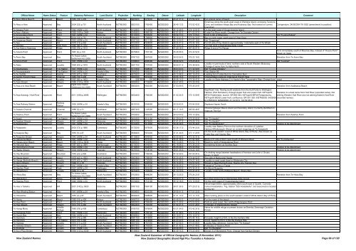
Official Name Name Status Feature Statutory Reference Land District Projection Northing Easting Datum Latitude Longitude Description Comment<br />
Te Akau (Black Beach) Approved Beach 1983 (18) p.409 Nelson NZTM2000 5483900 1679500 NZGD2000 40 47 31 S 173 56 32 E For original name <strong>of</strong> beach<br />
Small bay along the south-west coast <strong>of</strong> Waiheke Island, enclosing Tanerore<br />
Te Akau o Hine Approved Bay 2004 (33) p.751 North Auckland NZTM2000 5923100 1782400 NZGD2000 36 49 13 S 175 02 42 E Cove, and between Hitapa Bay and Kuakarau Bay. Not named on current<br />
map/chart<br />
Corrigendum: 24/06/2004 76:1852 (amendment to position)<br />
Te Akeake Point Approved Point 1940 (HON) p.34 North Auckland NZTM2000 6102600 1710500 NZGD2000 35 12 49 S 174 12 51 E On the west coast <strong>of</strong> Oruapukapuka Island<br />
Te Ana o Matuku Approved Cave 1992 (169) p.3464 Nelson NZTM2000 5345500 1466100 NZGD2000 42 01 52 S 171 22 57 E S side Fox River mouth. Change from Te Orumata Cavern<br />
Te Anaoipaikea Point Approved Point 1941 (HON) p.34 Gisborne NZTM2000 5717600 2055900 NZGD2000 38 34 23 S 178 13 55 E Point to SE <strong>of</strong> Whangara Not "Te Ana Paikea"<br />
Te Anauiarau Bay Approved Bay 2004 (33) p.751 North Auckland NZTM2000 5994300 1786600 NZGD2000 36 10 41 S 175 04 30 E Bay on north coast, south-west <strong>of</strong> Orau Cove<br />
Te Angaanga Beach Approved Beach 1943 (HON) p.34 North Auckland NZTM2000 6107100 1611100 NZGD2000 35 10 44 S 173 07 19 E Not "Ongaonga"<br />
Te Apu Approved Hill 1978 (13) p.422 South Auckland NZTM2000 5723300 1928600 NZGD2000 38 34 41 S 176 46 19 E For hill (site <strong>of</strong> trig. Station) approximately 1 kilometre west <strong>of</strong> Te Whaiti.<br />
Te Apunga Approved High Point 1980 (66) p.1752 Wellington NZTM2000 5653500 1862900 NZGD2000 39 13 41 S 176 02 44 E For high point in Kaimanawa State Forest<br />
Te Ara Kake a Haereroa Approved Ridge 1992 (78) p.1513 Southland NZTM2000 4764300 1202200 NZGD2000 47 09 16 S 167 45 07 E Ridge S end <strong>of</strong> Tin Range<br />
Te Araara Point Approved Point 1967 (4) p.120 North Auckland NZTM2000 6075800 1757100 NZGD2000 35 26 56 S 174 43 52 E<br />
Point immediately south <strong>of</strong> Maomao Bay. Instead <strong>of</strong> "Araora Point"<br />
shown on maps<br />
Te Ārero Bay Approved Bay<br />
Te Arawa Lakes<br />
Settlement Act 2006<br />
South Auckland NZTM2000 5787100 1897500 NZGD2000 38 00 54 S 176 23 19 E Alteration from Te Arero Bay<br />
Te Ariuru Point Approved Point 1941 (HON) p.34 Gisborne NZTM2000 5768600 2068300 NZGD2000 38 06 32 S 178 20 24 E Not "Te Ariuri"<br />
Te Atatu Approved Locality 1994 (42) p.1574 North Auckland NZTM2000 5921700 1747000 NZGD2000 36 50 21 S 174 38 55 E<br />
Locality on peninsula <strong>of</strong> land, northern side <strong>of</strong> North Western Motorway.<br />
Change <strong>of</strong> name from Te Atatu North<br />
Te Atuahautapu Approved Trig Station 1941 (HON) p.34 Gisborne NZTM2000 5777600 1998000 NZGD2000 38 03 43 S 177 32 09 E Not "Te Atua Ahutapu"<br />
Te Atuaoparapara Approved Trig Station 1944 (HON) p.34 Hawke's Bay NZTM2000 5590000 1869200 NZGD2000 39 47 51 S 176 08 39 E Trig. Station 66.<br />
Te Au Saddle Approved Saddle 1953 (67) p.1920 Southland NZTM2000 4975900 1154800 NZGD2000 45 13 46 S 167 19 43 E Leading from Forster Burn to Coronation Burn<br />
Te Aumiti (French Pass) Approved Channel 1983 (18) p.409 Nelson NZTM2000 5469700 1670200 NZGD2000 40 55 15 S 173 50 01 E Original Maori name for Channel at French Pass<br />
Te Aute Approved Locality 1997 (60) p.1403 Hawke's Bay NZTM2000 5587600 1913600 NZGD2000 39 48 14 S 176 39 47 E Locality on State Highway 2 in Hawke's Bay Topographic Map. Change from Opapa<br />
Te Aute Stream Approved Stream 1989 (120) p.3005 North Auckland NZTM2000 5908400 1732800 NZGD2000 36 57 40 S 174 29 30 E<br />
Te Awa a te Atua Beach Approved Beach<br />
Ngāti Awa Claims<br />
Settlement Act 2005<br />
South Auckland NZTM2000 5800200 1930300 NZGD2000 37 53 09 S 176 45 20 E Alteration from Awāteatua Beach<br />
Significant river, flowing south-westerly from the Hutt Forks to Wellington<br />
Harbour (Port Nicholson), through Upper Hutt and Lower Hutt. NZTopo50 Alteration to a dual name from Hutt River (recorded name). Not<br />
Te Awa Kairangi / Hutt River Approved River <strong>2011</strong> (168) p.4696 Wellington NZTM2000 5454400 1786300 NZGD2000 41 02 25 S 175 12 59 E BP33-Featherston, source: GR 863 544, NZTopo50 BP32-Paraparaumu, altering Western Hutt River and not altering Eastern Hutt River<br />
Te Awa Railway Station Approved<br />
Railway<br />
Station<br />
1930 (HON) p.34 Hawke's Bay NZTM2000 5619100 1936500 NZGD2000 39 30 43 S 176 54 50 E<br />
NZTopo50 BQ32-Lower Hutt, confluence: GR 591 329 (NZTM2000: 5432900 (recorded names).<br />
N 1759100 E; NZGD2000: 41 14 23 S 174 53 55 E).<br />
Replaces Napier South<br />
Te Awaatu Channel Approved Channel 1988 (2) p.31 Southland NZTM2000 4967400 1125300 NZGD2000 45 17 10 S 166 56 48 E<br />
Channel between Bauza Island and Secretary Island. Currently identified on<br />
maps as The Gut<br />
Te Awahou Point Approved Point<br />
Te Arawa Lakes<br />
Settlement Act 2006<br />
South Auckland NZTM2000 5783600 1882900 NZGD2000 38 03 04 S 176 13 26 E Alteration from Awahou Point<br />
Te Awaiti Approved Trig Station 1941 (HON) p.34 Wellington NZTM2000 5404300 1814100 NZGD2000 41 29 04 S 175 33 52 E Not "Te Awaite"<br />
Te Awakari Stream Approved Stream 1941 (HON) p.34 Gisborne NZTM2000 5814100 2079600 NZGD2000 37 41 41 S 178 26 17 E Not "Te Awakiri"<br />
Te Awakautuku Approved Locality 1941 (HON) p.34 South Auckland NZTM2000 5720300 1912900 NZGD2000 38 36 38 S 176 35 36 E Not "Te Awakautoku" Position to be determined<br />
Te Awaparahi Approved Locality 2003 (73) p.1896 Canterbury NZTM2000 5172000 1579000 NZGD2000 43 36 17 S 172 44 23 E<br />
Locality near Battery Point on the northern shoreline <strong>of</strong> Lyttelton<br />
Harbour/Whakaraupō. Shown on current mappings as Te Awaparahi<br />
Te Awapuia Bay Approved Bay 1953 (3) p.87 South Auckland NZTM2000 5838200 1970200 NZGD2000 37 31 44 S 177 11 20 E<br />
On the south-eastern coast <strong>of</strong> White Island, Bay <strong>of</strong> Plenty. Also known as<br />
Crater Bay and Sulphur Bay<br />
Te Awapuka Stream Approved Stream 1943 (HON) p.34 North Auckland NZTM2000 6115800 1649400 NZGD2000 35 05 58 S 173 32 31 E<br />
Te Hahaenga Block Approved Block 1941 (HON) p.34 Gisborne NZTM2000 5706100 2027200 NZGD2000 38 41 26 S 177 54 39 E Block on E side <strong>of</strong> SH 2 near mouth <strong>of</strong> Waipaoa River Not "Te Hahainga"<br />
Te Hakapureirei Beach Approved Beach 1985 (155) p.3636 Otago NZTM2000 4989300 1432900 NZGD2000 45 13 48 S 170 52 17 E Beach to north <strong>of</strong> Waiarakarua River<br />
Te Hakuwai Spur Approved Ridge 1987 (62) p.1964 Marlborough NZTM2000 5315000 1649900 NZGD2000 42 18 56 S 173 36 20 E Sometimes known as Scotties Spur<br />
Te Hangohango Creek Approved Stream 1943 (HON) p.34 North Auckland NZTM2000 6116500 1646200 NZGD2000 35 05 36 S 173 30 25 E Position to be determined<br />
Te Haoko Stream Approved Stream 1939 (HON) p.34 Taranaki NZTM2000 5679700 1718700 NZGD2000 39 01 25 S 174 22 16 E Position to be determined<br />
Te Hau Mountain Approved Mountain 1949 (22) p.858 Southland NZTM2000 5054500 1196300 NZGD2000 44 32 59 S 167 55 04 E<br />
On dividing range between headwaters <strong>of</strong> Harrison and John o' Groats<br />
Rivers. 5,334 ft<br />
Te Haupa Island Approved Island 1979 (42) p.1553 North Auckland NZTM2000 5957800 1756500 NZGD2000 36 30 45 S 174 44 52 E Sea side <strong>of</strong> Mahurangi Heads<br />
Te Henga (Bethells Beach) Approved Locality 1979 (42) p.1553 North Auckland NZTM2000 6006500 1730900 NZGD2000 36 04 38 S 174 27 14 E Locality on west coast close to Waitemata City<br />
Te Henui Stream Approved Stream 1966 (1) p.18 Taranaki NZTM2000 5662900 1690500 NZGD2000 39 10 42 S 174 02 52 E Stream in <strong>New</strong> Plymouth area, flowing into Tasman Sea<br />
Te Heruotaraia Approved Locality 1941 (HON) p.34 Hawke's Bay NZTM2000 5656500 2018300 NZGD2000 39 08 25 S 177 50 21 E Instead <strong>of</strong> Te Heru o Taraia<br />
Te Heuheu Peak Approved Peak 1937 (HON) p.34 Wellington NZTM2000 5650400 1822400 NZGD2000 39 16 02 S 175 34 41 E On Mount Ruapehu<br />
Te Hikowhenua Approved Locality 1966 (1) p.18 Wellington NZTM2000 5435400 1743600 NZGD2000 41 13 12 S 174 42 47 E Locality 1 mile north <strong>of</strong> Makara Beach, Ohariu Bay<br />
Te Hīnau Bay Approved Bay<br />
Te Arawa Lakes<br />
Settlement Act 2006<br />
South Auckland NZTM2000 5763900 1898200 NZGD2000 38 13 25 S 176 24 23 E Alteration from Te Hirau Bay<br />
Te Hiwiokaituri Approved Ridge 1980 (66) p.1752 Wellington NZTM2000 5661800 1854000 NZGD2000 39 09 21 S 175 56 22 E For ridge 4 kms long in Kaimanawa State Forest<br />
Te Hoanga Point Approved Point 1940 (HON) p.34 North Auckland NZTM2000 6103600 1712100 NZGD2000 35 12 16 S 174 13 53 E On the north coast <strong>of</strong> Oruapukapuka Island<br />
Hill at height 650m, approximately 20km south-east <strong>of</strong> Opotiki. Currently<br />
Te Hoe a Taikehu Approved Hill 2001 (142) p.3600 Gisborne NZTM2000 5781700 1994100 NZGD2000 38 01 36 S 177 29 21 E named Hoiataikahu. Trig. Station "525 Hoiataikahu" (not beaconed) is located<br />
on this hill<br />
Te Hoe Whaling Station Approved Site 1941 (HON) p.34 Hawke's Bay NZTM2000 5659600 2020200 NZGD2000 39 06 41 S 177 51 33 E<br />
Te Hokowhitu Approved Beach 1953 (3) p.87 South Auckland NZTM2000 5839200 1968600 NZGD2000 37 31 14 S 177 10 13 E Maori landing place on the south-western coast <strong>of</strong> White Island, Bay <strong>of</strong> Plenty<br />
Te Horea Approved Beach 1983 (18) p.409 Nelson NZTM2000 5486700 1680400 NZGD2000 40 46 00 S 173 57 09 E For the name <strong>of</strong> the beach<br />
Te Hue Point Approved Point 2004 (33) p.751 North Auckland NZTM2000 5993500 1784400 NZGD2000 36 11 09 S 175 03 02 E Point on west coast, 1km north <strong>of</strong> Ngorengore Point<br />
Te Hue Stream Approved Stream 1973 (15) p.365 South Auckland NZTM2000 5802400 1763300 NZGD2000 37 54 41 S 174 51 28 E A tributary <strong>of</strong> Waitomotomo Stream<br />
Te Huingi Manu Approved<br />
Wildlife<br />
Refuge<br />
1983 (18) p.409 Canterbury NZTM2000 5180100 1576600 NZGD2000 43 31 54 S 172 42 37 E<br />
Name for wildlife refuge at present known as Bromley Sewerage Oxidation<br />
Ponds<br />
Te Humenga Point Approved Point 1941 (HON) p.34 Wellington NZTM2000 5400400 1783100 NZGD2000 41 31 38 S 175 11 41 E<br />
Te Huruhi Bay Approved Bay 1940 (HON) p.34 North Auckland NZTM2000 6096800 1710600 NZGD2000 35 15 57 S 174 12 57 E<br />
Te Huruhuru Approved Peak 1973 (15) p.365 Canterbury NZTM2000 5081700 1419800 NZGD2000 44 23 44 S 170 44 14 E For peak, height 5,219 ft, in the the Hunters Hills<br />
Te Huruhuru Approved Trig Station 1973 (15) p.365 Canterbury NZTM2000 5081700 1419800 NZGD2000 44 23 44 S 170 44 14 E Trig K, height 5,219 ft, in the the Hunters Hills<br />
Te Hutewai Approved Locality 1974 (11) p.233 South Auckland NZTM2000 5807200 1761400 NZGD2000 37 52 06 S 174 50 06 E Locality Map reference, Correct form "Te Hutiwai"<br />
Te Hutewai Stream Approved Stream 1974 (11) p.233 South Auckland NZTM2000 5807900 1763900 NZGD2000 37 51 42 S 174 51 48 E A tributary <strong>of</strong> Opotoru River<br />
Te Ihooterei Approved Locality 1941 (HON) p.34 Hawke's Bay NZTM2000 5627800 1931300 NZGD2000 39 26 08 S 176 50 57 E Not "Te Ihuotekai"<br />
Te Ika a Piua Stream Approved Stream 1994 (133) p.4349 North Auckland NZTM2000 6146800 1636300 NZGD2000 34 49 14 S 173 23 49 E Stream S <strong>of</strong> Maraewhiti Point. Change from Karikari Stream<br />
<strong>New</strong> <strong>Zealand</strong> <strong>Names</strong><br />
<strong>New</strong> <strong>Zealand</strong> <strong>Gazetteer</strong> <strong>of</strong> Official Geographic <strong>Names</strong> (8 <strong>November</strong> <strong>2011</strong>)<br />
<strong>New</strong> <strong>Zealand</strong> Geographic Board Ngā Pou Taunaha o Aotearoa Page 99 <strong>of</strong> 120


