Gazetteer of New Zealand Names - 3 November 2011
Gazetteer of New Zealand Names - 3 November 2011
Gazetteer of New Zealand Names - 3 November 2011
Create successful ePaper yourself
Turn your PDF publications into a flip-book with our unique Google optimized e-Paper software.
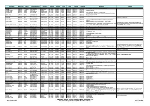
Official Name Name Status Feature Statutory Reference Land District Projection Northing Easting Datum Latitude Longitude Description Comment<br />
Wairaka Beach Approved Beach 1994 (133) p.4349 North Auckland NZTM2000 6148300 1635500 NZGD2000 34 48 25 S 173 23 17 E Beach between Taumatara Point and Maraewhiti Point<br />
Wairakai Approved Trig Station 1945 (HON) p.40 Hawke's Bay NZTM2000 5566200 1898500 NZGD2000 40 00 06 S 176 29 48 E<br />
Wairakaia Stream Approved Stream 1953 (3) p.87 Gisborne NZTM2000 5696200 2026100 NZGD2000 38 46 48 S 177 54 16 E Instead <strong>of</strong> Wairekaia<br />
Wairakau Stream Approved Stream 1943 (HON) p.40 North Auckland NZTM2000 5937300 1825800 NZGD2000 36 40 59 S 175 31 37 E<br />
Wairake Stream Approved Stream 1973 (15) p.365 South Auckland NZTM2000 5804400 1755300 NZGD2000 37 53 41 S 174 45 59 E Flows into the sea with outlet at Ruapuke Beach<br />
Wairaki Island Approved Island 1987 (163) p.4458 Southland NZTM2000 4931500 1103600 NZGD2000 45 35 33 S 166 38 08 E<br />
One <strong>of</strong> two islands commonly known as the 'Outer Gilbert Islands' south <strong>of</strong><br />
Breaksea Island, Fiordland<br />
Wairapukao Stream Approved Stream 1941 (HON) p.40 South Auckland NZTM2000 5809500 1887000 NZGD2000 37 49 01 S 176 15 37 E Not "Wairapukau"<br />
Wairau Bay Approved Bay<br />
Te Arawa Lakes<br />
Settlement Act 2006<br />
South Auckland NZTM2000 5783200 1893600 NZGD2000 38 03 05 S 176 20 45 E Confirmation <strong>of</strong> Wairau Bay<br />
Wairau Valley Approved Suburb 2007 (138) p.3623 North Auckland NZTM2000 5928500 1755300 NZGD2000 36 46 36 S 174 44 25 E<br />
North Shore City Suburb centred around NZMG coordinate 2665850E<br />
6490300N<br />
Waireia Stream Approved Stream 1975 (62) p.1632 South Auckland NZTM2000 5817600 1870700 NZGD2000 37 44 56 S 176 04 21 E A western tributary <strong>of</strong> Wairoa River. Instead <strong>of</strong> "Wairea Stream"<br />
Wairēinga / Bridal Veil Falls Approved Waterfall <strong>2011</strong> (168) p.4696 South Auckland NZTM2000 5802700 1766700 NZGD2000 37 54 29 S 174 53 46 E<br />
Waterfall on Pakoka River, north <strong>of</strong> Aotea Harbour, and approximately 11km<br />
south <strong>of</strong> Raglan, NZTopo50 BD32-Raglan, GR 667 027.<br />
Spelling alteration <strong>of</strong> an <strong>of</strong>ficial name from Waireinga/Bridal Veil<br />
Falls (macron added). Replacing previous <strong>New</strong> <strong>Zealand</strong> Gazette, 16<br />
October 2008, No. 159, page 4193.<br />
Wairepo Arm Approved Bay 1989 (62) p.1435 Otago NZTM2000 5103900 1318700 NZGD2000 44 09 50 S 169 28 54 E East <strong>of</strong> Ohau power station on Ohau River<br />
Wairepo Bay Approved Bay 1991 (32) p.687 Otago NZTM2000 5090800 1367300 NZGD2000 44 17 56 S 170 04 59 E SE side Wairepo Arm<br />
Wairere Stream Approved Stream 1937 (HON) p.40 Wellington NZTM2000 5659100 1819600 NZGD2000 39 11 23 S 175 32 34 E On the north slopes <strong>of</strong> Mount Ruapehu<br />
Wairere Stream Approved Stream 1989 (120) p.3005 North Auckland NZTM2000 5922600 1732100 NZGD2000 36 49 60 S 174 28 53 E<br />
Wairereata Falls Approved Waterfall 1938 (HON) p.40 Southland NZTM2000 5049800 1195900 NZGD2000 44 35 30 S 167 54 32 E On the Harrison River<br />
Wairiki Point Approved Point 1940 (HON) p.40 North Auckland NZTM2000 6099200 1712600 NZGD2000 35 14 38 S 174 14 15 E<br />
Wairoa Falls Approved Waterfall 1978 (82) p.2675 South Auckland NZTM2000 5841400 1850700 NZGD2000 37 32 25 S 175 50 15 E For waterfall at head <strong>of</strong> Wairoa Stream<br />
Wairoa Stream Approved Stream 1943 (HON) p.41 North Auckland NZTM2000 6108500 1613700 NZGD2000 35 09 59 S 173 09 02 E Hume Creek<br />
Wairoa Stream Approved Stream 1941 (HON) p.41 North Auckland NZTM2000 6108200 1613600 NZGD2000 35 10 09 S 173 08 58 E Not "Weiroa"<br />
Waitaha Cove Approved Cove 1991 (153) p.3226 Wellington NZTM2000 5421700 1749800 NZGD2000 41 20 32 S 174 47 26 E Between Arthurs Nose and Te Raehaihau, Lyall Bay<br />
Waitakaruru River Approved River 1950 (70) p.1989 South Auckland NZTM2000 5877700 1812600 NZGD2000 37 13 23 S 175 23 46 E<br />
Description amended from "Stream" to avoid confusion with Waitakaruru<br />
Stream near Morrinsville<br />
Waitakere Approved Town 1939 (HON) p.41 North Auckland NZTM2000 5920700 1737400 NZGD2000 36 50 59 S 174 32 28 E Not "Waitakerei"<br />
Waitakere Bay Approved Bay 1988 (206) p.5173 North Auckland NZTM2000 5915200 1727500 NZGD2000 36 54 02 S 174 25 52 E Bay north <strong>of</strong> Te Henga locality<br />
Waitakere Block Approved Block 1939 (HON) p.41 North Auckland NZTM2000 5921100 1737000 NZGD2000 36 50 46 S 174 32 12 E Not "Waitakerei"<br />
Waitakere River Approved River 1939 (HON) p.41 North Auckland NZTM2000 5918600 1731900 NZGD2000 36 52 10 S 174 28 47 E Not "Waitakerei"<br />
Waitakuhuruhuru Stream Approved Stream 2008 (177) p.4620 North Auckland NZTM2000 6029060 1664850 NZGD2000 35 52 50 S 173 43 06 E<br />
Not named on map west <strong>of</strong> the bridge at SH12, and altered from<br />
Stream located approximately 13km northwest <strong>of</strong> Dargaville, and flowing<br />
Taita Stream for that part <strong>of</strong> the stream flowing easterly from the<br />
generally northeasterly into Kaihu River, source P07 755910, confluence P07<br />
bridge at SH12 and into Kaihu River. Subject to Te Roroa Claims<br />
803940<br />
Settlement Act 2008.<br />
Waitangi Bay Approved Bay<br />
Te Arawa Lakes<br />
Settlement Act 2006<br />
South Auckland NZTM2000 5768800 1896900 NZGD2000 38 10 47 S 176 23 22 E Confirmation <strong>of</strong> Waitangi Bay<br />
Waitangi Stream Approved Stream 1975 (62) p.1632 Hawke's Bay NZTM2000 5614400 1935900 NZGD2000 39 33 16 S 176 54 33 E<br />
Flows from the vicinity <strong>of</strong> Meeanee to join the common mouth <strong>of</strong> the Tutaekuri<br />
and Ngaruroro Rivers<br />
NZTopo50 BP31-Porirua, GR 555 424, and NZTopo50 BP32-Paraparaumu,<br />
Waitangirua Approved Suburb 2010 (173) p.4271 Wellington NZTM2000 5441300 1759000 NZGD2000 41 09 50 S 174 53 43 E GR 589 434, and NZTopo50 BQ31-Wellington, GR 557 418, and NZTopo50<br />
BQ32-Lower Hutt, GR 590 413.<br />
Assigning an existing recorded name.<br />
Waitangirua Stream Approved Stream 1943 (HON) p.41 Gisborne NZTM2000 5819800 2055100 NZGD2000 37 39 22 S 178 09 28 E<br />
Waitaro Stream Approved Stream 1989 (120) p.3005 North Auckland NZTM2000 5916300 1744200 NZGD2000 36 53 18 S 174 37 06 E Tributary <strong>of</strong> Opanuku Stream<br />
Waitata Bay Approved Bay 1940 (HON) p.41 North Auckland NZTM2000 6098000 1702900 NZGD2000 35 15 21 S 174 07 52 E In Oneroa Bay<br />
Bay along the southern shoreline <strong>of</strong> Lyttelton Harbour/Whakaraupō, 1km<br />
Waitata/Little Port Cooper Approved Bay 2003 (73) p.1896 Canterbury NZTM2000 5171100 1585000 NZGD2000 43 36 47 S 172 48 51 E south-west <strong>of</strong> Adderley Head. Updating to current dual naming format. Shown<br />
on current mapping as Little Port Cooper<br />
Waitatapia Stream Approved Stream 1969 (8) p.240 Wellington NZTM2000 5477100 1791600 NZGD2000 40 50 05 S 175 16 21 E In Tararua Range<br />
Waitauri Stream Approved Stream 1989 (120) p.3005 North Auckland NZTM2000 5913700 1735700 NZGD2000 36 54 47 S 174 31 24 E<br />
Waiteika Stream Approved Stream 1973 (15) p.365 South Auckland NZTM2000 5793200 1767000 NZGD2000 37 59 37 S 174 54 07 E<br />
Flows westerly from vicinity <strong>of</strong> Moerangi Trig. To Aotea harbour. Instead <strong>of</strong><br />
"Waitieka Stream"<br />
Waitepipi Stream Approved Stream 1973 (15) p.365 South Auckland NZTM2000 5751900 1776300 NZGD2000 38 21 49 S 175 01 05 E Tributary <strong>of</strong> the Mangapu Stream<br />
Waitere Stream Approved Stream 1984 (1) p.24 Otago NZTM2000 4841900 1338500 NZGD2000 46 31 32 S 169 35 25 E Name for stream<br />
Waitete Stream Approved Stream 2003 (73) p.1896 South Auckland NZTM2000 5782100 1828700 NZGD2000 38 04 48 S 175 36 27 E<br />
Stream located west <strong>of</strong> Arapuni, flowing generally north-easterly into the<br />
Waikato River. Spelling correction from Waiteti Stream<br />
Waiteti Approved Locality 1973 (15) p.365 South Auckland NZTM2000 5749100 1791200 NZGD2000 38 23 09 S 175 11 21 E<br />
For the locality situated approximately 4 miles south <strong>of</strong> Te Kuiti. Also for<br />
stream and viaduct in vicinity<br />
Waitetī Bay Approved Bay<br />
Te Arawa Lakes<br />
Settlement Act 2006<br />
South Auckland NZTM2000 5781000 1882300 NZGD2000 38 04 29 S 176 13 06 E<br />
Waitetuna Block Approved Block 1941 (HON) p.41 Wellington NZTM2000 5395600 1793700 NZGD2000 41 34 04 S 175 19 23 E Not "Waitutuma"<br />
Waitetuna Stream Approved Stream 1941 (HON) p.41 Wellington NZTM2000 5395800 1793900 NZGD2000 41 33 58 S 175 19 32 E Not "Waitatuna"<br />
Waitetuna Stream Approved Stream 1941 (HON) p.41 Wellington NZTM2000 5394700 1793500 NZGD2000 41 34 33 S 175 19 16 E Not "Waitutuna"<br />
Waitewaewae River Approved River 1969 (8) p.240 Wellington NZTM2000 5484400 1792700 NZGD2000 40 46 08 S 175 16 60 E In Tararua Range<br />
Waitewhena Railway Siding Approved Railway Line 1939-1945 (HON) p.41 Taranaki NZTM2000 5720300 1773000 NZGD2000 38 38 56 S 174 59 17 E<br />
Waitewhena Stream Approved Stream 1939-1945 (HON) p.41 Taranaki NZTM2000 5717400 1774300 NZGD2000 38 40 29 S 175 00 13 E<br />
Waitioka Stream Approved Stream 1975 (62) p.1632 South Auckland NZTM2000 5824900 1858400 NZGD2000 37 41 12 S 175 55 49 E A tributary <strong>of</strong> Whatakao Stream. Instead <strong>of</strong> "Waitaioka Stream"<br />
Waitoetoe Approved Locality 1950 (70) p.1989 Taranaki NZTM2000 5684500 1724600 NZGD2000 38 58 47 S 174 26 19 E Instead <strong>of</strong> Waitoitoi. Also <strong>of</strong>ficial by 1939 Hon p. 41<br />
Waitoetoe Post Office Approved Post Office 1950 (70) p.1989 Taranaki NZTM2000 5684500 1724900 NZGD2000 38 58 47 S 174 26 31 E Instead <strong>of</strong> Waitoitoi<br />
Waitoetoe River Approved River 1950 (70) p.1989 Taranaki NZTM2000 5685100 1724200 NZGD2000 38 58 27 S 174 26 02 E Instead <strong>of</strong> Waitoitoi. Also <strong>of</strong>ficial by 1939 Hon p. 41<br />
Located adjacent to Wellington’s Centennial Highway (SH1), flowing<br />
southeasterly from the suburb <strong>of</strong> Johnsonville into Wellington Harbour (Port Alteration from Ngauranga Stream (<strong>of</strong>ficial). Port Nicholson Block<br />
Waitohi Stream Approved Stream 2009 (131) p.3074 Wellington NZTM2000 5432100 1752000 NZGD2000 41 14 54 S 174 48 49 E Nicholson), topographic map 260-R27,R28&Pt.Q27-Wellington, source: GR (Taranaki Whānui ki Te Upoko o Te Ika) Claims Settlement Act<br />
Waitohu Stream Approved Stream 1969 (8) p.240 Wellington NZTM2000 5488400 1779100 NZGD2000 40 44 09 S 175 07 16 E<br />
615 964, confluence: GR 620 938. Replacing previous <strong>New</strong> <strong>Zealand</strong> Gazette, 2009<br />
25 October 1951, No. 82, page 1607.<br />
Just north <strong>of</strong> Otaki Beach<br />
Waitoki Stream Approved Stream 2004 (33) p.751 North Auckland NZTM2000 5993300 1787100 NZGD2000 36 11 13 S 175 04 51 E Stream flowing north into Te Ananuiararau Bay<br />
Waitotara Approved Locality 1941 (HON) p.41 Gisborne NZTM2000 5723800 2060800 NZGD2000 38 30 54 S 178 17 02 E Not "Waiotara" Position to be determined<br />
Waitotara River Approved River 1941 (HON) p.41 Gisborne NZTM2000 5723400 2060600 NZGD2000 38 31 07 S 178 16 55 E Not "Waiotara"<br />
Waitotaranui Creek Approved Stream 1975 (62) p.1632 Marlborough NZTM2000 5286000 1638500 NZGD2000 42 34 39 S 173 28 09 E Flows out to coast<br />
<strong>New</strong> <strong>Zealand</strong> <strong>Names</strong><br />
<strong>New</strong> <strong>Zealand</strong> <strong>Gazetteer</strong> <strong>of</strong> Official Geographic <strong>Names</strong> (8 <strong>November</strong> <strong>2011</strong>)<br />
<strong>New</strong> <strong>Zealand</strong> Geographic Board Ngā Pou Taunaha o Aotearoa Page 114 <strong>of</strong> 120


